Nature's Handiwork in Sandstone
COYOTE A BIZARRE LANDSCAPE SCULPTED FROM ANCIENT SAND DUNES BUTTES
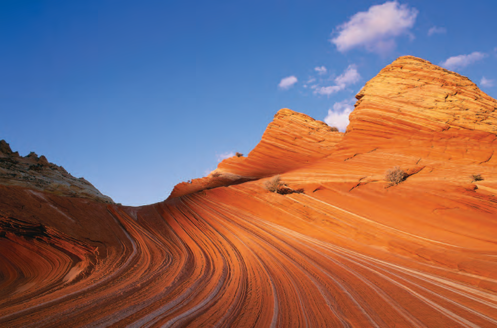
COYOTE BUTTES,
A fanciful microcosm of sculpted sandstone unlike any other place in Arizona, lies hidden within a maze of colorful cliffs, canyons and buttes about 40 miles west of Page, along the Arizona-Utah border in the Paria Canyon-Vermilion Cliffs Wilderness.
Worn smooth by wind, water and time, Coyote Buttes' slanted and curved layers-called crossbeds-represent the steep faces of oncegiant sand dunes. Ancient winds piled the sand about 150 million years ago, during the late Jurassic Period. Today, these swirling formations are exposed along the crest of the Paria Plateau, one of the lower steps of the "grand staircase" of geologic layers stretching from Utah's high plateaus south to the Grand Canyon.
Bizarre patterns in the rock create a threedimensional jigsaw puzzle for the eyes. Myriad colors decorate the petrified dunes, a by-product of the groundwater that helped turn a great sandpile into the famous Navajo sandstone of the Colorado Plateau.
Long ago, weathering sculpted the compacted strata deposited over an ancient coastal plain according to the hardness of each layer. Some wore away into valleys and curvaceous slopes, and some held fast as benches and ridges standing over the valleys, creating today's sandstone formations.
Established by an act of Congress in 1984, Coyote Buttes is found within the 110,000-acre wilderness protecting the wild and twisting canyons of the Paria River and the 2,000-foottall escarpment of the Vermilion Cliffs. Once home to the ancestral (Text continued on page 28)(Continued from page 24) Puebloan people, also called the Anasazi, and later part of the route crossed by Spanish explorers with the DominguezEscalante Expedition in 1776, this area is one of Arizona's newest public lands - the Vermilion Cliffs National Monument, signed into law by President Bill Clinton in 2000. To capture the best light, photographers who revere this landscape set out on foot before sunrise and return well after sundown. They hike with careful steps, walking softly and using care when setting up tripods, to leave the canyon as they found it and hoping all who come after them will feel the same.
EDITOR'S NOTE: To help protect this popular and fragile area, camping is prohibited, and hiking permit applications must be submitted several months in advance to the Bureau of Land Management, Arizona Strip Field Office, (435) 688-3230.
To reach Coyote Buttes from Page, drive west for about 30 miles into Utah on U.S. Highway 89 to the Paria Canyon Ranger Station. At the big bend in the highway some 5 miles past the station, turn left onto the unmarked dirt road where you will find the Wire Pass trailhead after another 9 miles.
The challenging but rewarding 3.5-mile trail to Coyote Buttes requires a topographic map and route-finding ability, and is best hiked with a dependable companion. The landscape is not friendly in the heat of summer-there is little shade, no dependable water and sections of soft sand to cross. Hikers can enjoy this remote adventure by carrying plenty of water and a flashlight, even when the plan is to return before sundown.
To protect and conserve Coyote Buttes for future generations, only 10 visitors per day are permitted access. All
Already a member? Login ».