Distinctly Arizona: The Places That Define Us
Since the end of World War II in 1945, more than 5 million people have settled in Arizona, many drawn to the state by its reputation for idyllic weather and its majestic and varied landscapes.
So dramatic is the scenery that many areas and images have become identified uniquely with Arizona: the Grand Canyon, the Petrified Forest, the red rocks of Sedona, glorious sunrises and sunsets, saguaro cacti, the wonderland of rocks, the Superstition Mountains, Monument Valley. The list goes on and on.
Arizona truly is an inspiring land.
This year, in celebration of the state and as Arizona Highways' annual greeting card to the world, we present an expanded portfolio of these magnificent Arizona icons. We hope you enjoy it, and have a joyful and peaceful holiday season.
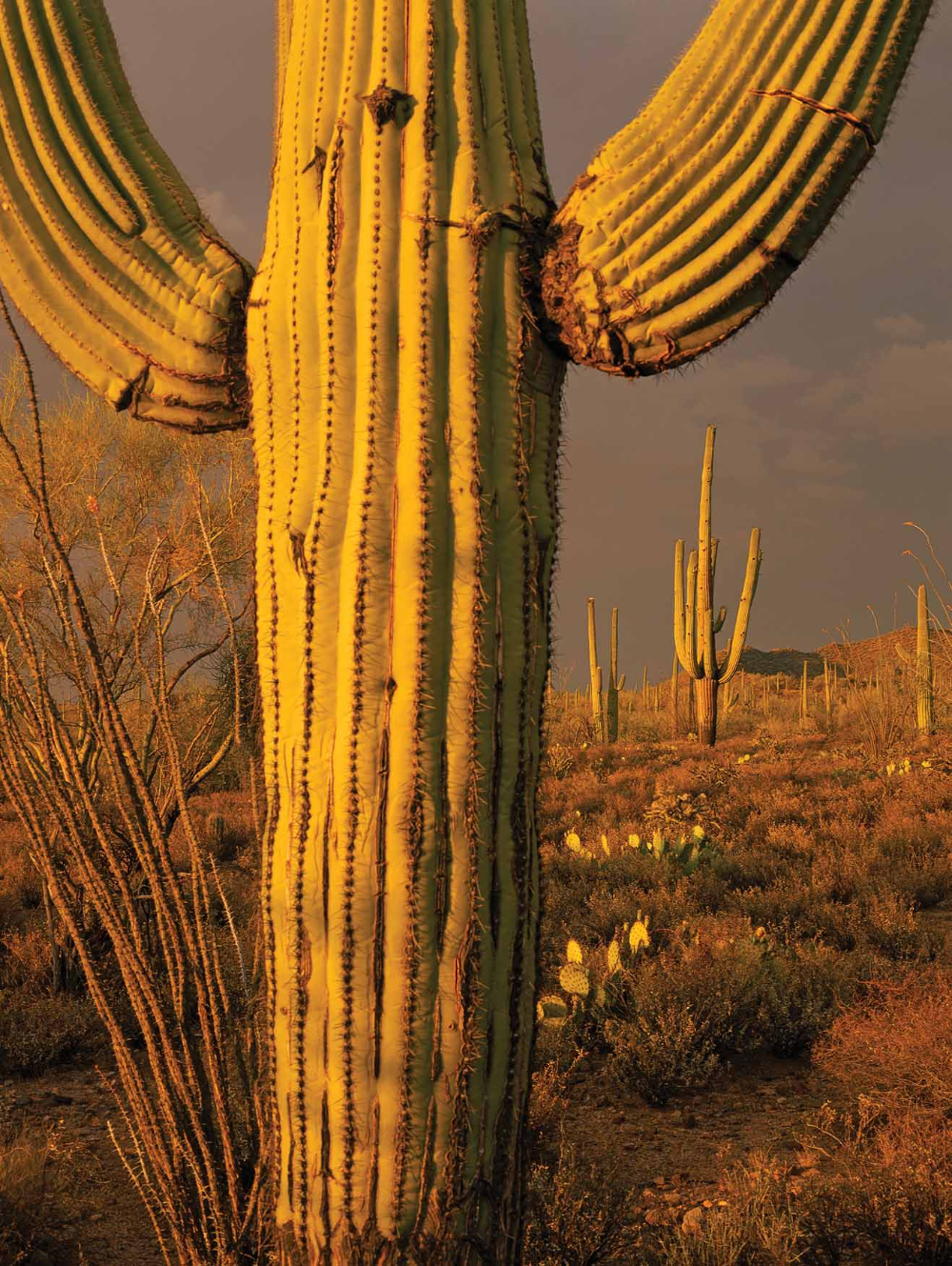
Arizona's iconic saguaro cacti. {Saguaro Cactus
The giant saguaro cactus, especially one standing gloriously in the foreground of an Arizona sunrise, symbolizes Arizona's southwestern lowlands more than any other image. The adult saguaro grows to more than 40 feet tall (record heights are more than 70 feet) and can weigh 2 tons or more. Mature saguaros live in excess of 150 years, perhaps as long as 200 years. Its anthropomorphic arms make it the subject of myriad photographs and cartoons. So prominent is the saguaro image that readers who will never see the real thing recognize it immediately in magazines, newspapers and brochures. And the saguaro's blossom is the Arizona state flower.
The handsome cactus grows only in the Sonoran Desert, which stretches across southwestern Arizona, reaches slightly into California and flanks both sides of Mexico's Sea of Cortes.
{Grand Canyon
While the saguaro cactus serves as the symbol of Arizona, the Grand Canyon represents the state's majesty. One mile deep, 10 to 18 miles wide and 277 Colorado River miles long, this imposing chasm draws millions of tourists from around the world each year to stand and ogle at its scenic splendor. But only a tiny fraction of those experience the Canyon by trekking its rocky floor, reveling in refreshing waterfalls and streams, braving the frigid Colorado River, laboring with legs aching up its torturous trails, rubbing a hand along 2 billionyear-old slick rock, called schist, or feeling the searing heat of summer or the snowy cold of winter. To experience the Canyon means to marvel at its enormity. Or to watch the sunlight play on the shale, sandstone, limestone and other rock formations, causing their colors to change almost minute by minute. Or to admire the redbud trees and coyote willows that hang over beds of watercress and crimson monkeyflowers at Vaseys Paradise. Or to see the plethora of streams, waterfalls and ponds. Or simply to wonder at the creation of this great landform. The Grand Canyon truly is one of the great natural wonders of the world.
{Superstition Mountains
The Superstition Mountain range, today an outdoor lovers' paradise east of Phoenix, has a history clouded in mystery. These mountains are the presumed location of the most famous mine legend of the West, the Lost Dutchman Gold Mine, supposedly a rich body of gold ore found and mined by Jacob Waltz, the Dutchman. Waltz and a partner reportedly learned about the mine from a descendant of the mine's original owners, who were killed by Apaches. One day in the 1870s, Waltz went for supplies and when he returned found his partner murdered. Fearful, Waltz hid in the mine's entrance and left, returning occasionally (some say into the 1880s) for more ore. In some versions of the tale, he made a crude map before he died in 1892, but it never helped the gold seekers who tried to follow it. Whether the story is true, more than 60 persons have died violently trying to find the mine. Today mainly hobbyists search for the mine, but the real value of the Superstitions is their recreational opportunities and scenery. Hikers, backpackers, campers, horseback riders and other outdoor enthusiasts revel in this vast mountain range.
{Monument Valley
Monument Valley on the Navajo Indian Reservation announced itself to the world in director John Ford's 1939 Western movie Stagecoach. Coincidentally, that same movie made John Wayne a top box office attraction. The success of Stagecoach and its Monument Valley backdrop gave rise to a series of movies, television shows and commercials, spreading the valley's reputation.
And once the world discovered Monument Valley, it came to see the monoliths, hoodoos and other sandstone formations that rise out of the rippling sand in this section of Navajoland. Names of the rocky spires also have become well known: The Mittens, Three Sisters, The Thumb, Camel Butte, Ear of the Wind, Eagle Mesa and Totem Pole among them.
The Navajos recognized John Ford's part in popularizing Monument Valley. In 1955, during the filming of the movie The Searchers, he was made an honorary member of the tribe, given the name Natani Nez (“Tall Soldier”) and presented a deerskin containing this message: “In your travels may there be beauty behind you, beauty on both sides of you, and beauty ahead of you.” Today the area has been designated a Navajo tribal park, and some 200,000 travelers tour the valley each year.
{ Canyon de Chelly
White House Ruins and Spider Rock in Canyon de Chelly National Monument on the Navajo Indian Reservation represent different tales of the Navajo people in ancient times and frontier days. The ruins, a cliff dwelling inhabited by the ancestral Puebloans from about A.D. 1066 to 1275, are the largest remaining of about 400 such structures constructed in the area. There were about 80 rooms and four kivas where religious ceremonies were performed. Ropes or wooden ladders were used to go in and out.
Spider Rock is a sacred place to the Navajos. Spider Woman, it is said, lives there, and Blessingway ceremonies are performed there. Spider Woman is believed to have taught the people how to weave. There also are those who say mothers warn their children to be good or else Spider Woman will come take them to her home and eat them. The white on top of the 800-foot-tall sandstone monolith supposedly represents the bleached bones of naughty children. Canyon de Chelly and its companion to the north, Canyon del Muerto, have been occupied by the Navajos for about 300 years. De Chelly is a 27-mile-long gash in the earth with Edenlike beauty. Dominant trees include cottonwoods and willows, both native species, plus Russian olives, tamarisks and peach-leaf willows, exotics introduced for erosion control.
Though located on a remote area of the Navajo Reservation, Canyon de Chelly's scenic beauty attracts hundreds of thousands of visitors each year.
{Painted Desert
Marked by the pigmented badlands of the Painted Desert and one of the world's largest collections of petrified wood, the nearly 94,000acre Petrified Forest National Park awes sightseers and photographers as one of the most scenic landscapes in Arizona. What appears first as a vast, flat desert opens to a variety of geological formations, crystallized trees and ancient Indian sites. In the late Triassic period, about 225 million years ago before the great continent split apart, this area in northeast Arizona was located near the equator, a land of rivers and swamps and, in the drier areas, conifer trees up to 200 feet tall. Insects, reptiles and amphibians abounded. Over eons, the uplift of the Colorado Plateau, volcanoes and the vicissitudes of weather transformed the area. Eventually groundwater dissolved silica from the volcanic ash and mixed with other chemicals to create logs crystallized with the rainbow colors of amethyst, quartz and citrine. The three main species of trees, preserved only as petrified wood, are now extinct. The park's numerous archaeological sites and petroglyphs record more than 10,000 years of ancient cultures who made their homes in this arid desert region. To add to the enchantment of the land comes a myth-those who dare to steal a piece of the petrified wood, an illegal action in itself, will suddenly find themselves plagued with bad luck. Stacks of confession letters and returned pieces of stolen wood make their way back to park officials every year.
{Havasu Falls
The brilliant blue-green waters of Havasu Falls spill from red cliffs and collect in cool travertine pools far below the rims of the Grand Canyon on the Havasupai Indian Reservation. Despite the 8-mile hike down to the village of Supai, and another 2 miles to Havasu Creek and the campground, visitors flock to the falls each year to enjoy the scenery, to splash around in the creek and to explore the other falls in the area. A high concentration of limestone gives the waters their intense aquamarine color, and the bright sunlight reflecting off the travertine dams that form below make the water appear to glow. At a year-round temperature of about 70 degrees, the water from the falls makes a popular cooling off spot for summer tourists. The Havasupai Indians have lived in this canyon-bottom paradise for centuries, and their culture thrives on tourism in this hidden land.
{Kartchner Caverns
Drops of water. Cracks in the limestone. That's all it took to create the living formations that have been growing in Kartchner Caverns for tens of thousands of years. Drip by drip, acidic rainwater dissolved large passages in the base of the Whetstone Mountains. Eventually the water table lowered, exposing caverns hidden below the desert floor. The rainwater, however, didn't stop seeping in, and over thousands of years the dissolved mineral deposits dripped from the cavern ceiling, leaving behind colorful formations in the hollow belly of the mountains. Kartchner Caverns, now a state park, is visited by thousands of tourists each month and is another in a wide variety of geological formations that comprise the scenic diversity of Arizona. Among the notable formations in the caverns is one of the world's longest soda straw stalactites at 21 feet 2 inches. These caverns also serve as home to some 1,000 pregnant bats, who arrive in late April. Each female gives birth to one pup and, before the bats leave in September, the colony consumes nearly a half-ton of insects.
While exploring the limestone hills in the Whetstones in 1974, two men discovered a narrow crack from which warm, moist air escaped. After years of exploration, that narrow crack led to what is now the 7-acre Kartchner Caverns State Park.
{San Francisco Peaks
Flagstaff, the northern Arizona city nestled in the foothills of the San Francisco Peaks, is among the state's most popular tourist destinations. Humphreys Peak, which at 12,633 feet is usually snowcapped from fall to spring, dominates the landscape and serves as the icon for Flagstaff. The area, at about 7,000 feet in elevation, abounds in aspen and pine forests and cool summer temperatures. In spring the wildflowers blanket the great meadows, particularly in places like Hart Prairie in the mountains' inner basin. The city, a hub on the old U.S. Route 66, also serves as one of the gateways to both the North and South rims of the Grand Canyon and to myriad other geological and historical sites, including Sunset Crater Volcano, Wupatki and Walnut Canyon national monuments, Lowell Observatory, where the planet Pluto was discovered, Riordan Mansion State Historic Park and the Museum of Northern Arizona. Besides sightseers, Flagstaff draws countless outdoor enthusiasts who come to hike, mountain bike, fish, climb mountains or otherwise enjoy the mountain air. Then, in wintertime as the snow returns, the mountains become a mecca for skiers.
{Oak Creek Canyon
For a cool, relaxing day of hiking and splashing around in a creek, residents of north-central Arizona head to Oak Creek Canyon between Sedona and Flagstaff. The winding two-lane highway that runs through the canyon, State Route 89A, has changed little since it was built in the 1930s, and neither has the scenery. Photographs of Oak Creek Canyon adorn books, magazines and calendars published throughout the world because of its lush scenic beauty. Bigtooth maples, sycamores, Emory oaks, ponderosa pines and other trees and shrubs complement the towering outcrops of white limestone cliffs. The West Fork of Oak Creek provides a quiet, peaceful hiking experience enjoyed by both the young and the old, the expert trekker and the beginner.
The streambed adds to the scenic splendor and also provides swimming holes that are visited each summer by tens of thousands of tourists and residents alike. Slide Rock State Park, about 7 miles north of Sedona, is a focal point of such activity.
{Red Rocks of Sedona
Among the most famous places in Arizona is Red Rock Country near Sedona, which sprang from a tiny farm-ing village in the early 1900s into today's cluster of top-line resorts, fine restaurants and shops. People come for the scenery and they stay for the scenery. Hiking, backpacking and jeep tours among such formations as Bell Rock, Coffee Pot Rock and Cathedral Rock lure tourists year-round to Sedona and its environs.
In recent years, Sedona also has become a haven for New Agers who believe spiritual energy is concentrated in some of the red rock vortexes. And, drawn by the rich reds of the unusual landscape, fine artists have migrated to Sedona, causing a blossoming of art galleries and other high-end shopping.
{Colorado River
The Colorado River not only provides life-sustaining water for the desert Southwest through the creation of reservoirs and irrigation channels, but it also makes possible recreational opportunities that draw visitors from around the world every month. The river was a main force in forging the Grand Canyon and provides the water for Lake Powell, Lake Mead, Lake Havasu and other reservoirs as it reaches from northern Arizona into Mexico. Rafting the Colorado through the Grand Canyon remains one of the world's great river trips and is so popular that applicants wait years to obtain rafting permits. Houseboating vacations on Lake Mead and Lake Powell attract everyone from jazz bands to extended families. Boating on Lake Havasu and the lower Colorado runs the gamut from waterskiing to canoeing and kayaking. Fishing, of course, is world class in many areas of the river.
{Chiricahua Mountains
There is a saying in Arizona that if the balanced rocks, spires and hoodoos of the Chiricahua Moun-tains were in any other state they would be among the most-visited sites in the country. But their popularity has become dwarfed in Arizona by the Grand Canyon and our other scenic wonders. Located in the southeastern corner of the state, the Chiricahuas were formed by a slow uplift that fractured the volcanic rock, creating a wonderland of rocks with names like Punch and Judy and Kissing Rocks. In 1924 President Calvin Coolidge signed legislation making a large portion of the range a national monument.
Cochise and his band of Apaches used the Chiricahuas as their home ground, employing the serpentine rock pathways as ways to escape pursuing soldiers. Many of those same pathways today have become hiking trails valued not only for their unusual landscapes but also because of the flora and fauna that can be seen in the area, such as white-tailed deer and the rare elegant trogon.
A narrow road crosses the mountains, winds through lush green forests and leads to the tiny hamlet of Portal. This roadway, often closed by heavy snows in winter, draws birders from around the world because of the great number of avian species to be found there.
Heart of Rocks in the Chiricahua National Monument. LAURENCE PARENT {Slot Canyons AND Sand Dunes
Many people who have only heard about Arizona believe it is a desert lowland with enormous sand dunes and little in the way of greenery. In fact, Arizona contains eight life zones and has everything from sandy bottoms to mountain pine forests. There are some windswept sand dunes, though, near Yuma and on the northeastern section of the Navajo Indian Reservation. But those are relatively small areas. Most of our desert contains greenery such as cacti, creosote bushes and other shrubbery, flowers like evening primrose and purple sand verbena, plus trees, including paloverdes and manzanitas. The Southwest deserts, though hot and dry, bear little resemblance to the barren deserts of the movies. First-time travelers to Arizona often are amazed by the lushness of our deserts.
Another geologic feature that surprises visitors and newcomers alike are the slot canyons of northern Arizona. Slot canyons, found in and around Lake Powell and along the Arizona border with Utah, are crevices sculpted by water in sandstone. The slots display a full range of colors as sunlight seeps into them, highlighting the various shades of sandstone. Because they are very unusual geologic features, camera buffs from around the world come to photograph them. Upper Antelope Canyon, the most famous one, has appeared in photography magazines and scenic coffee-table books again and again. Visitors find lower Antelope Canyon intriguing as well.
{Lake Powell
Lake Powell was created by a 710-foot-high dam on the Colorado River that was completed in 1963 across Glen Canyon at the east end of the Grand Canyon. It has more water storage capacity than any other artificial lake in the United States except Lake Mead, which impounds the Colorado at the western end of the Grand Canyon. Lake Powell has a shoreline of nearly 2,000 miles and is a boater's paradise. Kayakers especially find the lake appealing because of the myriad side canyons that can be explored. Accessibility to side canyons changes depending on the water levels in the lake, making no two experiences alike.
But houseboats also are dominant on Lake Powell as large groups meander the lake amid the cliff-side splendor, pulling smaller boats for waterskiing and fishing. Sandy beaches provide ideal camping spots.
Like most rock formations, Lake Powell's sandstone cliffs, arches and natural bridges display a variety of colors as the sun moves across the horizon. Hanging gardens of maidenhair ferns, columbines and other water-loving plants can be found in the sandstone alcoves.
Lake Powell is the centerpiece of the Glen Canyon National Recreation Area, which covers 1.25 million acres spreading from Arizona into Utah. Rainbow Bridge National Monument, about 50 miles from the dam, protects the world's largest natural bridge, a sacred site to the Navajo Indians. The bridge can be reached by hiking or by boat. All
A GATHERING of LADYBUGS IN COLD HIGH-MOUNTAIN ELEVATIONS, THE LITTLE RED BEETLES HUDDLE TO WAIT FOR SPRING
Hundreds OF LADYBIRD BEETLES cruise this way and that way, high and low, as they cross a clearing in the pine forest near Barfoot Lookout in southeastern Arizona's Chiricahua Mountains. The little dots of red on the go appear to be the product of a random-movement generator designed to catch and befuddle the eye of an observer. And so it takes some time for me to realize that the flying ladybirds are just the tip of the iceberg, so to speak, a deep orange-red iceberg composed of thousands upon thousands of ladybirds festooning the branches and bunches of needles on certain of the pines surrounding the glade. Armies of ladybirds (or ladybugs as they are often called) also coat some fallen limbs as well as entire pine seedlings on the edge of the clearing while smaller clusters have even formed on the yellow daisies that are now in bloom in the late summer.
A closer look at the beetles blanketing one plant reveals that some individuals are moving about a bit restlessly, but many simply hold their place, each beetle adding its dot of color to the mosaic of reds. Here and there a pair of beetles mates, the male holding on precariously to the smooth rounded back of the female. Having done a little reading on ladybirds, I know that many of the 400 or so species of ladybird beetles get together in big conventions in the late summer and fall. In the West, some species assemble on hilltops and mountain ridges where they pile in side by side, forming groups of a few dozen to many thousands of individuals. There they sit, cooling down as winter approaches, generally under the cover of boulders, limbs, dense pine branches and other protective materials. When winter really comes,
Already a member? Login ».