The Scenic Back Roads of Organ Pipe
ANNOUNCING A NEW BOOK FROM ARIZONA HIGHWAYS
If you enjoyed the 16 paved-highway tours described in the Arizona Highways book Travel Arizona, you'll be eager to take the next step: venturing onto the state's back roads to experience a side of Arizona less adventuresome folks may never have the opportunity to admire.
Travel Arizona: The Back Roads is available for $9.95 plus $1.00 postage. To order, write or call Arizona Highways Magazine, 2039 W. Lewis Ave., Phoenix, AZ 85009; telephone (602) 258-1000.
The following article by Sam Negri is adapted from the new book: Organ Pipe Cactus National Monument in the southwestern borderlands of Arizona will amaze you. It virtually overflows with the beauty of Sonoran Desert flora and fauna, and its two spectacular back roads promise to make a desert lover out of almost anyone.
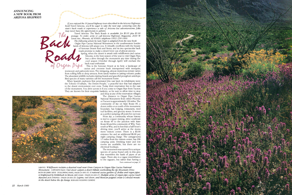
Spring, when the desert is awash with wildflowers and cactus blooms, is the best season of the year to visit Organ Pipe, but a drive through the monument any time during the cool season (October through April) will enchant the back road enthusiast.
This is the Sonoran Desert at its best: a landscape of cactus and creosote bush interspersed with mesquite, ironwood, and paloverde trees. The intriguing, almost mysterious terrain varies from rolling hills to deep arroyos, from sandy washes to jutting volcanic peaks. The abundant wildlife includes darting lizards and graceful pronghorn antelope. Bird species of many varieties call the monument home.
When Spanish explorers first penetrated this vast land, its inhabitants were the Tohono O'odham, "the Desert People," a peaceful race that had adapted to the desert environment over eons. Today their reservation lies to the east of the monument. You drive across it if you come to Organ Pipe from Tucson. They are known for their exquisite basketry, so be sure to allow time to stop and shop at any of the reservation villages. The distance to Organ Pipe Cactus National Monument from either Phoenix or Tucson is approximately 130 miles. The community of Ajo on State Route 85, a dozen miles or so north of the monument boundary, has lodging, restaurants, med-ical facilities, and grocery stores. It serves as a perfect jumping-off point for our tour.
From Ajo, a community whose history is tied to copper mining, drive southeast on Route 85 to the junction with State Route 86 and the community of Why. Turn south at Why, and in less than a half-hour's driving time, you'll arrive at the monu-ment visitors center. There is a $3.00 entrance fee and an additional $6.00 per night camping charge. The campground, 1.5 miles from the visitors center, has 208 camping units. Drinking water and rest rooms are available, but there are no electrical hookups.
The monument was named for a unique species of cactus found only in this area that resembles the bank of pipes of an organ. There also is a vague resemblance to the saguaro, but rather than having a main trunk with a few smaller branches, the organ pipe cactus has many branches that rise from a central base in a cluster of thick arms that may grow as high as 20 feet. Like the saguaro, the organ pipe produces impressive blossoms in May and June.
Back Roads
The senita, or old man cactus, is another unusual plant flourishing here in this fertile Sonoran Desert environment. It looks somewhat like a diminutive organ pipe, but the tips of each arm are covered with spiny whiskers, which give it the Spanish name for "old one."
There are two scenic drives in the monument, which covers 516 square miles of rugged desert country bordered by jagged mountain peaks. Both loops are graded gravel roads, easily maneuvered in a standard passenger vehicle, and both take you through beautiful Sonoran Desert landscape.
To the west of the visitors center on State Route 85 is the 35-mile Puerto Blanco loop trail to Quitobaquito Spring, a freshwater oasis.
Like any reliable water hole in Arizona, the "little spring" has a long history. Melchior Diaz, a member of the Coronado expedition in 1540, probably stopped here. Jesuit missionary Eusebio Francisco Kino baptized Indian children near it in 1690. It also served as a key point on the desert trail he would blaze to the west, which later became known as the Devil's Highway. In 1860 a man named Andrew Dorsey settled at the spring and dug the pond that is there today. (See Arizona Highways, April 1978.) The other principal drive in the monument is the 21-mile Ajo Mountain loop, which begins east of State Route 85 and the visitors center and winds northeast to the jagged heights of the magenta-colored Ajo Mountains. The crest of the Ajos forms the boundary between the monument and the Tohono O'odham (Papago) Indian Reservation. There are two picnic areas along the route, one about five miles in and the other near the start of the Estes Canyon-Bull Pasture Trail.
The trail through Bull Pasture is a 3.4mile round trip, passing through an area rich in wildlife and vegetation. It becomes steep as it nears the top of the canyon; then it turns sharply to the north past a large outcropping of obsidian, which Indians have used for tools over the centuries.
On either drive through the monument, birdlife is abundant, but it is especially so at Quitobaquito Spring. Some 260 species of feathered creatures have been sighted in Organ Pipe. American kestrels, cactus wrens, curve-billed thrashers, Gambel's quail, phainopeplas, red-tailed hawks, roadrunners, and turkey vultures are common. Golden eagles and prairie falcons also have been seen.
Once back at the visitors center, you can return to Ajo via State Route 85, which brought you to this fabulous, wild, lonely, and beautiful corner of Arizona.
Already a member? Login ».