Back Road Adventure
BACK ROAD ADVENTURE Not Far from the Mexican Border the Road to Ruby Entices Nature Lovers to Stop and Look
It's a land of many windmills down here at the Mexican border. We come across a new one with gleaming blades, occupying the only flat ground for acres around. The sun bounces off its silver blades; the windmill hums and seems to smile. The rocky face of Montana Peak is straight ahead, its jagged crown poking a flat blue sky. We pull over, cut the engine, and listen. In these isolated mountains between the old village of Arivaca and willowlined Pena Blanca Lake, the stillness is creased only by the murmur of a windmill and the songs of a thousand birds.Well, it sounds like a thousand birds. Though it's likely only five or six, every sound is amplified. Each call stands out with increased definition against the backdrop of a quiet landscape in the high desert mountains. There's an army of birds out there, all singing in different languages.
Here on Arizona's wild and scenic border with Mexico, the hills are wide and deep, the shadows long. There is no hint that Tucson, the state's secondlargest city, is little more than an hour away.
This is a backcountry trip that is rewarding for the painter, photographer, mountain biker, bird-watcher, or camper. A 167-mile loop from Tucson to Arivaca and Pena Blanca Lakecan easily be covered in four hours, but Arivaca's territorial charm - engaging because of its authenticity - is likely to lure most visitors, including us, out of their cars for a longer stay. Set aside an entire day, as we did, and there will be time for a stroll around town, some bird-watching along Arivaca Creek, and a snack at Pena Blanca Lake. The loop includes 25 miles of unpaved road through a portion of the Coronado National Forest, beginning at Arivaca and extending east to Pena Blanca Lake. On most days, a two-wheel-drive vehicle can handle the dirt road, but you never know. When we drive it in May, most of the distance is smooth enough for an ordinary sedan, but one low spot near Warsaw Canyon looks like a giant meteor hit it the night before. A sedan would go home without its oil pan.
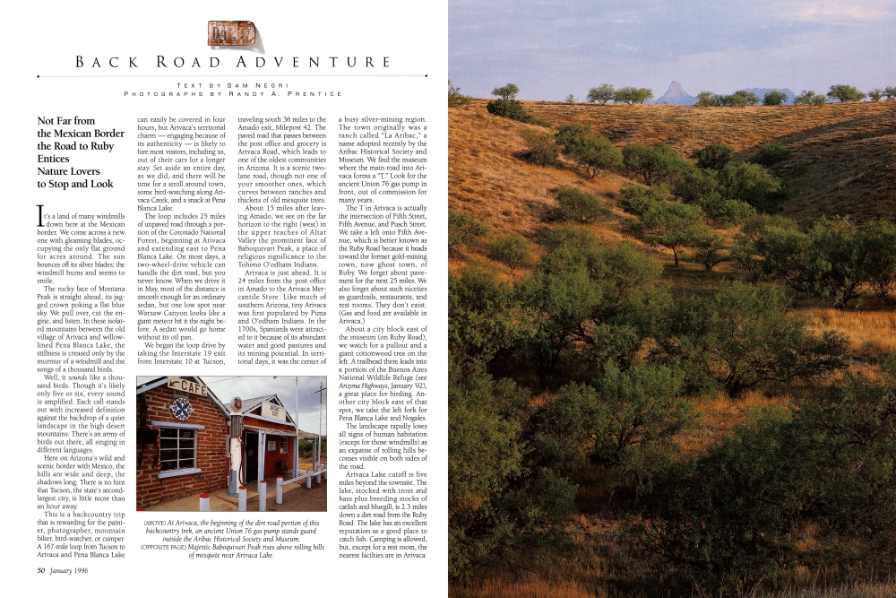
We began the loop drive by taking the Interstate 19 exit from Interstate 10 at Tucson, traveling south 36 miles to the Amado exit, Milepost 42. The paved road that passes between the post office and grocery is Arivaca Road, which leads to one of the oldest communities in Arizona. It is a scenic twolane road, though not one of your smoother ones, which curves between ranches and thickets of old mesquite trees. About 15 miles after leav-ing Amado, we see on the far horizon to the right (west) in the upper reaches of Altar Valley the prominent face of Baboquivari Peak, a place of religious significance to the Tohono O'odham Indians.
Arivaca is just ahead. It is 24 miles from the post office in Amado to the Arivaca Mercantile Store. Like much of southern Arizona, tiny Arivaca was first populated by Pima and O'odham Indians. In the 1700s, Spaniards were attracted to it because of its abundant water and good pastures and its mining potential. In terri-torial days, it was the center of In a busy silver-mining region. The town originally was a ranch called "La Aribac," a name adopted recently by the Aribac Historical Society and Museum. We find the museum where the main road into Arivaca forms a "T." Look for the ancient Union 76 gas pump in front, out of commission for many years.
The T in Arivaca is actually the intersection of Fifth Street, Fifth Avenue, and Pusch Street. We take a left onto Fifth Avenue, which is better known as the Ruby Road because it heads toward the former gold-mining town, now ghost town, of Ruby. We forget about pave-ment for the next 25 miles. We also forget about such niceties as guardrails, restaurants, and rest rooms. They don't exist. (Gas and food are available in Arivaca.) About a city block east of the museum (on Ruby Road), we watch for a pullout and a giant cottonwood tree on the left. A trailhead there leads into a portion of the Buenos Aires National Wildlife Refuge (see Arizona Highways, January '92), a great place for birding. Another city block east of that spot, we take the left fork for Pena Blanca Lake and Nogales.
The landscape rapidly loses all signs of human habitation (except for those windmills) as an expanse of rolling hills becomes visible on both sides of the road.
Arivaca Lake cutoff is five miles beyond the townsite. The lake, stocked with trout and bass plus breeding stocks of catfish and bluegill, is 2.3 miles down a dirt road from the Ruby Road. The lake has an excellent reputation as a good place to catch fish. Camping is allowed, but, except for a rest room, the nearest facilties are in Arivaca.
(LEFT) Pena Blanca Lake, below the Atascosa Mountains, attracts anglers looking for catfish, bluegill, and trout. (RIGHT) The Buenos Aires National Wildlife Refuge near Arivaca shelters more than 280 different kinds of birds.
From the lake cutoff, it is 6.6 miles farther to Ruby, a raucous gold-mining camp founded as the Montana Mine in the 1870s. (See Arizona Highways, November '94.) Postmaster Julius Andrews named the town for his wife, Lillie Ruby, in 1912. Ruby has some of the most extensive ruins of any ghost town in Arizona, but the townsite is privately owned and is strictly off-limits to visitors. For many years, the most famous sign in this area was the one on the gate at Ruby: PRIVATE PROPERTY NO TRESPASSING SURVIVORS WILL BE SHOT.
That sign has been softened a bit in recent years. Now it says trespassers will be prosecuted.
Five miles beyond Ruby, the road again comes to a T. We turn right, onto State Route 289, and almost immediately the entrance to Sycamore Canyon, a popular hiking and backpacking spot, appears. Sycamore Canyon (4,000 feet elevation), in the Goodding Natural Research Area, is part of the 7,420-acre Pajarita Wilderness.
The trail into the canyon begins at the sign for Hank and Yank Spring, named for ranchers Henry “Hank” Hewitt and John “Yank” Bartlett who lived there in the 1880s. (See Arizona Highways, January '80.) The terrain, filled with huge boulders, enticing caves, and tall oaks and sycamore trees, is surrounded by the rugged peaks of the Pajarita Mountains.
From Sycamore Canyon, it is 8.7 miles to the pavement and the Forest Service campground at the mile-long Pena Blanca Lake. There is a rustic motel with six units for rent, as well as a restaurant and bar.
It's 9.3 miles on a good paved road from the lake to I-19. At the interstate, we can turn south 7.5 miles to the border city of Nogales (where all services are available) or drive 57 miles north to return to Tucson. We decide to return to Tucson, glad we allowed enough time to savor the attractions of this backcountry loop.
Back road travel in more remote areas can be hazardous if you are not prepared for the unexpected. Whether traveling in the desert or in the high country, be aware of weather and road conditions, and make sure you and your vehicle are in top shape and you have plenty of water.
TIPS FOR TRAVELERS
Don't travel alone, and let someone at home know where you're going and when you plan to return. And remember that odometer readings vary by vehicle.
Already a member? Login ».