ROUNDING THE FOUR CORNERS
Twenty-five years ago, this September, we made our first visit to the Four Corners. We wanted to see the only spot in the United States where four states join hands. We'd been warned it was a rugged country, hard to penetrate. What we didn't know was that we'd be lured back, again and again by the region's charm. Now, a quarter of a century later, the Four Corners Country is recognized as one of the most progressive as well as dramatically scenic areas in the entire fifty states. Where else can you find, within a hundred-and-fiftymile radius, such as we suggest visiting in a private silver anniversary journey, more exciting variety? Endless sweeps of painted desert lift to massive plateaus where empires of undulating range country are cut by spectacular canyons; juniper-studded foothills mount in stairsteps to snow-tipped peaks of the Rocky Mountains. Cool highland lakes and rippling trout streams feed brawling desert rivers. The whole region, from blue vault over forested green down to redrock country, is a vast tinted background for man's unfinished story.
While Nero fiddled before burning Rome, there were people here in the tablelands and deserts. They have left their "cities" for us to marvel at, and some of their descendants still walk the streets of Hopiland in Arizona, the pueblos of New Mexico. The Apache, Navajo and Ute had ranged the open spaces for centuries before the Spanish came. During the last scant hundred years the Johnnie-come-lately white man has made a start on developing some of the fabulously rich natural resources. The Navajo is at work on his lands. Together they are opening the country now for the tourist-unrolling the red carpet of roads in every direction.
Welcomed by hospitable little towns in Arizona, Utah, Colorado and New Mexico, and by Indians on their reservations, we'll find creature comforts in each, as well as focal points for fascinating local adventures. With just ten days, we can't explore exhaustively, but we will loiter in five national monuments, hesitate among the greenery of national forests, sniff mountain air and desert incense, and gaze out over indescribably magnificent panoramas of desert and highland.
At the very least, these should be ten days of pleasant wandering. They can be more, if you wish. This big country offers a stretch to muscles, imagination and understanding. It proffers an insight into a remarkable 20th century phenomenon: the Navajo people emerging from a pastoral life of almost biblical simplicity directly into the push-button efficiency of the Atomic Age. It is very thrilling to see them striding into the golden future.
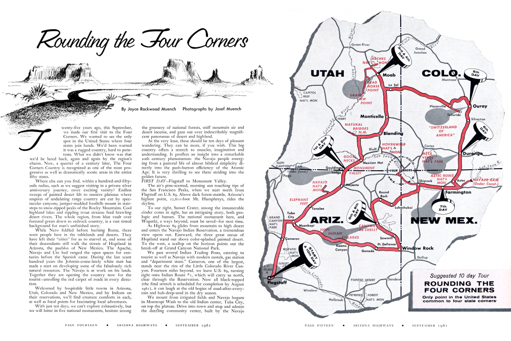
FIRST DAY-Flagstaff to Monument Valley.
The air's pine-scented, morning sun touching tips of the San Francisco Peaks, when we start north from Flagstaff on U.S. 89. Above dark forest-mantle, Arizona's highest point, 12,611-foot Mt. Humphreys, rides the skyline.
To our right, Sunset Crater, among the innumerable cinder cones in sight, has an intriguing story, both geologic and human. The national monument here, and Wupatki, a ways beyond, must be saved-for next time.
As Highway 89 glides from mountain to high desert and enters the Navajo Indian Reservation, a tremendous view opens out. Eastward, the three great mesas of Hopiland stand out above color-splashed painted desert. To the west, a scallop on the horizon points out the break-off at Grand Canyon National Park.
We pass several Indian Trading Posts, catering to tourist as well as Navajo with modern motels, gas station and "department store." Cameron, one of the largest, stands near the rim of the Little Colorado River Canyon. Fourteen miles beyond, we leave U.S. 89, turning right onto Indian Route #1, which will carry us north, clear through the Reservation. Now all black-topped (the final stretch is scheduled for completion by August 1961), it can laugh at the old bogies of mud-after-everyrain and hub-deep-sand in the dry season.We mount from irrigated fields and Navajo hogans in Moencopi Wash to the old Indian center, Tuba City, on top the plateau. Drive into town and stop and admire the dazzling community center, built by the Navajo
Suggested 10 day Tour ROUNDING THE FOUR CORNERS
Only point in the United States common to four state corners'
TOOT! TOOT!
Clang goes the bell, toot goes the whistle, puff goes the ball of black smoke and out of the windows pop some three hundred and seventy-five tourist heads, three days a week during the summer months as the last passenger-carrying narrow gauge railroad train in the U.S. chuffs up the Animas river canyon from Durango to Silverton and return.In this day of space achievements why should a little jerkwater trip on a baby-carriage train to a remote little town in a pocket of mountain hold such delight and fascination? Because it's the last of its kind for you and me and the first of its kind to most of the youngsters who know all about rockets but little about railroads; or perhaps whose railroad acquaintance has been limited to thundering diesel flyers that streak across the country, a silver sliver by day, a segmented glow-worm by night.
Open platforms, wiry-iron railings, windows that open, painted yellow wooden coaches, wood seats with iron chair arms-how unusual and interesting! A smokestack belching real smoke, the swinging motion of twenty-mile-per-hour progress-how new and exciting! To see the passengers literally bulging from all windows in the gaiety of vacation and the colors of summer reminds you of train scenes from the film "Around the World in Eighty Days" and not without reason. The D and R G cannonball was the one used in the picture and the scenes were shot in this location.
When they laid the first railroad across the plains into Colorado from the East it was a big and dangerous job but at least it was a horizontal one. Later, when the railroads pierced the mountains and canyons of the back country, the job was equally hazardous but added to that it was now vertical as welll The Denver and Rio Grande, first to employ the narrow gauge (light rails laid three feet apart) was dubbed the "baby railroad" but its stout little locomotives with proportionately sized freight and passenger cars were soon winding up the narrow canyons to almost inaccessible districts. These narrow gauge lines could just about "curve on the brim of a sombrero" and today, though all trunk lines have long since been converted to standard gauge, there are still many miles of baby railroads rusty and weed-grown in remote parts of the state.
Silverton, seat of San Juan county, was originally called Baker's Park after an early prospector but when a local mining operator claimed "We may not have gold here but we have silver by the ton" the name was changed to Silverton. San Juan county lays its own claim to fame: it is the up-and-downest county in the country that can boast, "Not a single acre of arable land!"
The train winds up the Animas river canyon to Silverton in time for lunch and sight-seeing around the town. For a number of years it was said that not a new house had been built there in 40 years; when you get there, you'll believe it! However, many of the old houses and buildings have been refurbished in the original style and no one should miss a visit to this unusually situated town.
Durango, seat of La Plata county, was founded in 1880 by the Denver and Rio Grande railroad to profit from the business created by building the road. It was the usual roistering frontier town and a streetcar line ran less than a year because "the crews were abusive and insulting to the patrons and the cars invariably pulled away from the station before all the incoming passengers could get aboard."
At another time the local newspaper reported that a group of men had left for La Boca, New Mexico to "dig up Aztecs." For this bit of archaeological research the party was outfitted as follows: thirty horses and fifteen burros, five cases of chewing tobacco, three cases of beer, ten gallons of heavy liquids (hot cake syrup?) seven reels of fuse, two boxes of cigars, a fishline, twenty pairs of rubber boots, one can lard, two hundred loaves of bread, one pound bacon. (that last . for flavoring?) Sometimes on the Durango-Silverton run, one can see the little yellow mighty midget rocking up the canyon while high overhead remains the trail of a jet airplane long since beyond the horizon; quite a span between the twol Scenery through Animas Canyon is spectacular and inaccessible except by train. Highway 550 parallels the railroad for a short distance north of Durango, then the roads separate. The highway traverses another route over the pass and The Little Train That Could . . . and still Can . . . tootles off into the yawning gorges of the San Juan Range.
NOTES FOR PHOTOGRAPHERS OPPOSITE PAGE
"VIEW FROM DEAD HORSE POINT-SOUTHEASTERN UTAH" BY JOSEF MUENCH. 4x5 Linhof camera; Ektachrome; f.22 at 1/10th sec.; 54" Tessar lens; September; sunny day. Photograph shows Dead Horse Point in Southeastern Utah, reached from U. S. 160 near Moab, Utah. The typical architecture of the Grand Canyon in Arizona is repeated here in "Utah's Grand Canyon," with the Colorado River winding around mesas in an amphitheatre of tiered cliffs.
FOLLOWING PAGE
"IN ARCHES NATIONAL MONUMENT-UTAH" BY JOSEF MUENCH. 4x5 Graphic View camera; Ektachrome; f.11 at 1/10th sec.; 54" Tessar lens; September; sunny day. The Double Arch in Arches National Monument in Southeastern Utah is one of the most spectacular of the area's many rock openings. The human figure suggests the immensity of the openings.
"IN BRIDGES NATIONAL MONUMENT-UTAH" BY WILLIS PETERSON. 314x414 Speed Graphic camera; Ektachrome; f.32 at 1/25th sec.; 4.7 Ektar lens; extremely bright day. In Natural Bridges National Monument in Southeastern Utah. Owachomo Bridge, a Hopi name, was one of the three natural bridges (in this Monument) first seen by white man in 1883 when Cass Hite, a prospector, visited the region. National publicity was given to the area in 1904 when an illustrated article appeared in the National Geographic Magazine. In 1908 the area was proclaimed Natural Bridges National Monument by President Theodore Roosevelt.
"VIEW FROM GRAND VIEW POINT-UTAH" BY JOSEF MUENCH. 4x5 Linhof camera; Ektachrome; f.16 at 1/50th sec.; 54" Tessar lens; September; sunny day. Photograph shows Monument Canyon and the Abajo Mountains as seen from Grand View Point, Southeastern Utah. This site is reached from U. S. 160, near Moab. A tremendous view enhanced with the startlingly white Cutler sandstone rimming the canyon below as foreground for rugged gorges of the Colorado River.
(Please turn to page twenty-five)
NOTES FOR PHOTOGRAPHERS CENTER PANEL
"MOUNTAIN PANORAMA-COLORADO" BY CHUCK ABBOTT. 5X7 Deardorff View camera; Ektachrome; f.22 at 1/10th sec.; Goerz Artar lens; late September; evening sunset; Weston 100 meter reading; ASA rating 40. Photograph taken on range land near Dallas Divide about fifteen miles west of Ouray, Colorado. Mt. Sneffels Range is shown in the background.
"ON THE NARROW GAUGE-COLORADO" BY ESTHER HENDERSON. 5x7 Deardorff View camera; Ektachrome; f.12.7 at 1/50th sec.; Goerz Dagor lens; mid-August; bright sun; Weston 200 meter reading; ASA rating 40. Photograph taken about one half mile down the tracks from Rockwood, a short stop some ten miles north of Durango, Colorado, a whistle-stop on the narrow gauge railway and off Highway 550 about two miles. Here "The Antique Cannon-Ball Limited" follows the Animas River up its canyon to Silverton. The river, seen below and to the right, offers good fishing. America's last narrow gauge railroad operated by the Denver and Rio Grande Western Railroad, passes through the spectacular Canyon of the Rio de Las Animas, from Durango to Silverton, a distance of forty-five miles. Durango, the hub of the San Juan Basin, is at an elevation of 6,520 feet. Silverton, historic mining camp, is at an elevation of 9,300 feet.
"OURAY, COLORADO" BY ESTHER HENDERSON. 5x7 Deardorff View camera; Ektachrome; f.18 at 1/25th sec.; commercial Ektar lens; mid-August; sunny, bright day; Weston 200 meter reading; ASA rating 40. Photograph taken from Million Dollar Highway 550 just south of Ouray as the road starts up the grade over Red Mountain Pass. Ouray, once an important silver mining town, is becoming an increasingly important travel and vacation center. It is called "the Gem City of the Rockies in the Switzerland of America."
"CLIFF PALACE-MESA VERDE NATIONAL PARK" BY FRED H. RAGSDALE. 5x7 Deardorff View camera; Ektachrome Daylight; f.22 at 1/25th sec.; Goerz Dagor 7" lens; August; bright sunlight, early afternoon; ASA rating 32 (by test, although rating on film given was 50). Cliff Palace is the largest prehistoric ruin in Mesa Verde National Park, in Southwestern Colorado. The flattopped mountain, whose deep canyons hide the desert cliff cities of a remarkable stone age civilization that flourished there a thousand years ago, was named by early Spanish explorers. Mesa Verde means "green table." The cliff dwellers of Mesa Verde abandoned the area during the great drought, 1276-1298 A.D.
OPPOSITE PAGE
"TUNNEL VIEWPOINT-CANYON DE CHELLY NATIONAL MONUMENT" BY JOSEF MUENCH. 4x5 Graphic View camera; Kodachrome; f.18 at 1/5th sec.; 54" Tessar lens; September; sunny day. Photograph taken in Canyon de Chelly National Monument on the Navajo Indian Reservation near Chinle in Northeastern Arizona. Here the viewer is looking through the tunnel on the trail from the White House Ruins Overlook on the Rim Road. The towering cliffs above and an Indian hogan and summer shelter below provide exciting contrasts.
JEEPERS
That's what they call these folks in the stub-nose cars and that's what the folks in the stub-nose cars exclaim when they reach the 13,000ft. level (a misnomer if ever there was one what's "level" at 13,000 feet?) with one wheel on the side of the mountain and the other wheel treading clouds! For a jeep is a sort of swollen-out vehicle. When you are in one and peer out, and down, there are times and places around Ouray when you THINK the outside wheel is on dry land but you can't be sure! To worriers like this we say, "Whatsa matter, you nervous or something? Watcha nervous about? We got four wheels and all three of them are right smack dab in the middle of the road." Well-that's when they say, "Jeepers!"
Ouray is jeep capital of America with more than three hundred miles of jeep roads through the surrounding country. Every year, jeepsters congregate in Ouray for a weekend of jeep-cavalcading, a unique sport made possible by the nature of the terrain and the mining that has taken place there.
Exciting roads that lead to mountain tops and back country are usually made by loggers; they are private roads, hazardous at all times, closed to ordinary traffic most of the time. Permission to use must be obtained before travel and after obtaining, roads are one-way at timed intervals and traffic is heavy in weight, bulk and quantity. Anyone who has ever met a loaded logging truck on a mountain road will understand the picture.
Not so in Ouray. The jeep roads of today were originally pack train roads to many long-gone mines. The mines, now mostly closed, leave the roads accessible and traffic-free; just right for the jeepers.
In these elevations the climate is likely to be moist thus rendering a logging road impassable at times. But the Rockies are aptly named. You may be obstructed by a snowbank, a landslide, a washout, but stuck-in-the-mud you'll never be.
What is it like, this jeeping along in the clouds? It's a new experience and quite incomparable to travel of any other kind; sort of composite voyage made up of 1/4 horse-jog, 1/4 wind-in-the-fase, 1/4 sailboating in the sky, 1/4 looking down on a pygmytized landscape wherein, contrary to reality, you are the king-pin and even the tallest tree becomes a blade of grass. If you are a frequent air-traveler you may be thinking you've been that high up lots of times. True, but in air travel you are so high up that you have lost contact and detail of the terrain.What difference does that make you may ask and the answer: all the difference in the world. For nowadays it's commonplace to soar to unbelievable heights in pressurized compartments; to partake of steak and champagne two miles up and a thousand miles from land. What is NOT commonplace is to tie a bandana around your hair and joggle up from Main Street to where the eagles soar; to breathe the winds that skim the loftiest peaks of the Rockies, to have at one and the same time, your head in the clouds and your feet on the ground.
Only by jeep-trip are you in intimate contact with flower-filled mountain meadows where acres of wild columbine cast a lavender glow over the timberline slopes; where alpine tarns in the high, cold rock escarpments meet summer but a few short weeks removed from returning winter.
Before time and events and circumstances made possible both the jeep and the roads, these wonderful regions were closed to all but the young, the hardy, and the adventuresome. You might be as adventurous as all get out in spirit but unless you are at least moderately young AND in condition, a mountain-climbing expedition could be uncomfortable and hazardous. The jeep-trips are made to order for the old, the young, the hasty (or the unhurried), for city and country-dweller alike. In fact, for all those who hear the call of far away places, who want to smell mountain winds across tundra, who want to hear the turbulent splash of alpine freshets, to feel the good earth of which are deprived so much of the time in our business-of-living-existence. To all those we sayCome with us! Experiencing is believing.
Tribal Council in 1960-with gymnasiom-auditorium (folding bleachers for 3,000), kitches and youth activity rooms.
Out beyond is the open Navajo Country, expansive, empty. Indian-driven pickups pass, loaded with blank-eted families. Herds of sheep and goats make little spots of life in the wilderness, and here and there a wiggly wedge of road winds off to a lonely bog, accentuating the space and solitude. A pair of mammoth, rock Elephant's Feet look incongruous near Tomlea. If your multi-horsepower engine didn't turn the wheels so fast, the few trading posts, the fewer windmills or water-holes would seem desperately far apart.
As a junction marked "Navajo National Monume," we turn left to the loveliness of all cliff dwellings. A 10-mile sound trip on graded road leads to Betatakin, accessible of the area's three major ruins. After a short walk on Sandal Trail, you see it from Betatakin Point, over a canyon brimming with yellow aspen trees, kindred buck-elder and green Douglas fir, its tiny houses set condo-like among soaring pylons of sandstone, in a cave.
Eating your bar lunch there, at the end of the wall, the quiet of two years since the squat, dark-haired Indians walked away, sets off the pure poetry of the setting, the perfection of stone apartments with wooden ladders leading to upper chambers.
Back on pavement, the landscape continues to play variations on rock uplift and plateau through Mars Pass to Kayenta. There is a sad moral here and trips to Monument Valley may be arranged with Bernie Baker, his his four-wheel drive equipment.
Another 25 miles flows through the "Gateway"-formed by the volcanic plug, "Agathlan," and the sandstone "Owl Butte," and to the first heart-warming view of the great sandstone formations of the incomparable Monument Valley. Late sun will be warming them into fiery hues as you cross the Utek border, swing left and mount to our night stop-Goulding's Trading Post and Lodge. (For mail reservations: write Goulding's Lodge, via Kayenta, Ariz. For phone reservations, call Goulding's Lodge, Mobil Unit 2, Monticello, Utah.) Formed try the volcanic plag, "Agathlan," and the sand-stone "Owl Batre," and to the first heart-warming view of the great sandstone formations of the incomparable Mocument Valley. Lane sum will be warming them inco flary buss as you cross the Utek bordar, swing left wad mount to our night step-Goulding's Trading Post and Lodge. (For asil reservations: write Goulding's Lodgs, vis Kaystea, Ariz. For phone reservations, call Goulding's Lodge, Mobils Unie z, Monticello, Utah.) SECOND DAY-Momuneet Valley Tour.
I'd be willing to place two beni with you on loκα-mear Valley-that you'll calce twice as many pictures an you expected to, and that, in spite of all you've heard-you'll be surprised. The conshtiation of red rock figur so articically placed sad the colorful Indians "at home" make a carmers go wild. And then, something new has been added. This is the first of the Navajo Tribal Parks (pettemed after the National Park System). Ar the vip-itor's osture on the Rin, Lodians in usiform grees you and collect şi tatzence foe. They are proud of the bulld-ing, where a silversmith works and regs and jeweky are on sale. From the observation room above, is a splendid view of the Valley.
You may drive your ows car, but only in parts and που το Εασίσει κικmps. Goulding's office four-wheel drive equipment with a driver-guide who is Novajo. Since this is one of the traditional swongholds of the sribe, you'll want to see it all. The hogaus, roomy and srsælling so plessently of coder, the men and women in their gaudy costames and above becbaric splendor of ruoquoise and silver jewelry. The shy children, ton, ατε perfect against the marvelous background of sandstone And space. To hear the Equid Navajo and enjoy thele haugisker (it doesn't matter if you don't understand the words), gives some insight into the rarosape of this sim phe way of fión. It is a pictare that is passing from many parts of the Reservation.
Back at Goulding's for manch-style dine in a dining room thet was once a part of a movis est, and even in your motel unit, the frieze of "Desert Skyscrapers," miles away-remalas visible. If you've lived sight, pesdepe * barruse nuwe will come up bebind them to "gild the Hly." Yoer bosta are Harry and "Mike" Goulding, who've been greeting visitors from the world over for more then yo years. With them are the Kuser-Meurico and Rossory.
If boring on a sare thing didu't seam uxsportingI'd put soms more money down that you'll be sorry to leave this magio-touched spot on the border.
THIRD DAY-Momoment Valley to Mosh, Deah. Utah Sate 47 swings up through Macrament Phas where you sea mocuments from now angles, and shen moves on toward Mexican Hat. There's a uralen plant plus company town on one plateau-top, trading post phas motel, buddled on a ledge in the San Juan River gorge sod another section of town visible when the zoed climbs back up on top after the bridge crowing. Beyond tends the sombrero-shaped rock-The Mexican Hat A Attis, road vore down to the right to give a guod angle of the Hat against the sky with the Seu Joas Anticlina as backdrop, Turning left on State 161 από εξαλα onto a good gravel road, beings us, after five miles, to a turn-around and views of the great Goosenecks of the San Joan. At your shos-tips is a deep gorge, sheer to the thin afbbon of brown water, saking in homeshos bends, carved to the river's ancient paxtars-almost, but cot quite biting thena into islands. To use for complete "necks" you swivel your own in a sto-degree swaen. Mid-day is im besz picture sima, but even a wide angle lens car't quite cope with the situation.
Pavement on soi cung to the base of Cedar Mesa where good gravel switchbacks up to king-sized views of the basin balow and the corkscrews just traversed.
On the Mesa top, ceder trees march clear to the horizon, while Bes Flowert, Penstortsoa and Indien Panthurusk pretty up the roadway and fresh highland air is spiced with th arsd code. On the far slcyline atend pioneer guidepose-the Bear's Ears, The Wooden Shes and tha Mom Backs, Soon afur 161 marges into State 95, we are at Natural Bridges National Monument, setting for thures tremendous witrite stone arches, carved by corm of tree and weattsar action. Two may be sown and photographed from lookom points, bạc the big "Sipapu," kides at the end of a wall, September would be most plesat co take the cirele hika and stand under each sharing spea apas, but witis jwet a bus-lunch top, you can at least appreciate the rockbound scanary and the inssenstry of "Owncluems" and "Kachiss,"
On the return trip, keep to State os, saat te pavement on 47. The shifting landscape, as you go up and down, is beautiful all the way and Comb Wash, which we croms, really spectacular. The towns of Blanding and Monticello are north, with a feather sy softes to our wigwam.
(Alternate Route for the Day). At the cost of bypassing the big bridges, you can stay on pavement and also include the Aneth Oil Field in your itinerary. After the Goosenecks and return to State 47, clean-cut uplifts are trimmed by the distant forms of the Abajo and La Sal mountains. Twelve miles beyond the quaint little Mormon town of Bluff, State 262 goes east to a lookout. Below is a huge basin, dotted at 80-acre intervals with slowly wagging pump heads. Push-button operated, pumping "black gold" into pipelines that feed off to western industry, they work without respite. Developed by oil companies on Tribal Lands, every downthrust and uplift means money for education, community centers-more prosperity for the Navajos. Leases and royalties paid to the tribe between 1958 and '60-totalled 60 million dollars.
FOURTH DAY-Moab, and Vicinity.
Moab, a fine biblical mouthful of a name, and vigorous little town on the Colorado River, is bursting at the seams with uranium, potash, new subdivisions and scenic background.
From headquarters of the Arches National Monument, on the north, a curving park road swings up to pause for a look at Park Avenue. A "stopper" viewfitting introduction to 4500 acres of arches, windows, bridges, sculptured figures in the brilliant red of Entrada Sandstone. No place on earth can compete in number or variety of rocky shapes. More and more roads are being paved on the monument to give you a chance to see more of them. You do still have a little walk to the slender span of Landscape Arch and a beautiful stroll over mounding slickrock before enjoying the privilege of viewing the one and only-Delicate Arch.
Bringing a box lunch along will save time because by afternoon we should be a few miles north on U.S. 160. From a junction marked "Dead Horse Point, 23 miles," the road is gravel and mounts to a broad mesa on which it runs south to the rim of Utah's Grand Canyon.
Three thousand feet down is the Colorado River, Winding among terraced cliffs of typical Grand Canyon architecture-but redder and closer. If you share the usual enthusiasm-you'll count this one view worth every one of the no-matter-how-many thousand miles you've come to see it.
Grand View Point, another "peninsula in the sky," is still farther out on the main plateau road. At the "Neck," the road passes over a 40-foot isthmus, dropping to the Colorado River on the left and to the Green River on the right. A cattle gate and fence suffices to shut off the 40,000-acre Gray's Pasture. At the far end of the table-land-way back of beyond-is Grand View Point.
The name is an understatement for the panorama of canyon, plateau, river and mountains which takes your breath right away. Below-cliffs drop in terraces to broad, winding benches and then drop again, giant steps down to the river's edge. When you've gazed until all the senses are saturated, it's time to go back to Moab.
Every evening, some local enthusiast shows slides of the area at Ross Musselman's Rock Shop-in an openair "projection room." You're welcome to come. All the visitors in town will be there.
From those evening showings you'll realize there is much more to see around Moab. State 128, for instance, will take you upriver to the slender fluted columns of the Fisher Towers. An admirable loop trip starts from 128 through Castle Valley-with rock embattlements looking down on fields and ranches-and climbs the shoulders of the La Sal Mountains. I don't know where Aspen Trees grow bigger or more golden, nor where overviews from the twisting roadway offer more ravish-ing vistas than on this drive, which finally drops to rejoin U.S. 160 at the airport, south of town.
FIFTH DAY-Moab, Utah, to Ouray, Colorado.
No one in Moab belittles the beauty of the La Sals, but if they know you're heading east into Colorado, they admit you'll be seeing some really big mountains in the "Switzerland of America." At La Sal Junction (south of town), State 46 carries us to the Colorado border. The countryside, as it lifts, is rolling and you pass the famous La Sal Ranch of the Redds with perhaps a glimpse of some of the best "white faces" in the state.
At the border, the route becomes Colorado 145 and zigzags down into Paradox. The valley is edged by red rocks with mountains jutting beyond and the unusual name comes from the Dolores River, which runs across the strike of the valley instead of with it as well-behaved streams are expected to do. Horse and cattle ranches and old placer mines enliven the foreground as we push deeper into the rugged San Juans that make such a grand background on the way to Placerville and finally-historic old Telluride.
The 8500-foot-high valley, in which the gold camp sits, with mountains embracing it, is steeped in memories of lively days back in the 19th century. A population of 5,000 and assets of 60 million dollars in gold are worth remembering. So is the alleged call of the conductor on the Rio Grande Southern (narrow gauge) Railroad, when it served the mountain mining centers. It sounded something like: "Ridgeway, Ouray, and To-hell-u-ride!"
After taking pictures of photogenic old-time buildings and enjoying the quite palpable atmosphere of a bygone day in Alpine setting, we backtrack to Placerville and take State 62 over the Dallas Divide on the Uncompaghre Plateau. The San Juan Mountains, with over 14thousand-foot Mt. Sneffels as climax, make a ragged skyline on your right-as wonderful a mountainscape as the globe offers. You'll find it very exhilarating and September a choice time to be driving toward Ridgeway. A high, fertile and warm-tinted valley takes us through more mountain along U.S. 550 to our night stop at Ouray. Expect slight delays. There are "speed-traps" in the form of hot springs, inviting campgrounds and trails that try to lure the visitor into the Uncompaghre Forest, with ever more commanding peaks bobbing into view around the horizon.
SIXTH DAY-Ouray to Durango, Colorado.
Ouray, which was named for a great Ute chief and nestles in a pear-shaped valley in the shadow of 12 and 13-thousand-foot peaks, takes hold of the visitor at first glance. For as long as you might elect to stay there, it will continue to provide interesting sights and activities. A truant elk from the nearby Uncompaghre Game Preserve may stare you down from someone's lawn. You can follow him back, afoot or horseback into prime wilderness. There is fishing in lakes and streams, picturesque old mining camps to photograph and a leaping falls in Box Canyon, right in town.
U.S. 550 switchbacks up a mountain side and looks right down into Ouray's back yards at the beginning of the Million Dollar Highway. Built by Otto Mears as a toll road, this superbly scenic route was first surfaced-When Otto Mears, one-time president of the Denver and Rio Grande Railroad and pioneer road builder in Colorado, engineered his toll road out of Ouray across Red Mountain pass, little did he suppose that a future highway (550) following his road would, in part, be surfaced with gold-bearing gravels worth a million dollars before the mistake was discovered. That was the mistake that gave the Million Dollar Highway its name. Although it cost many millions to build, the million that went into the unsuspected surface is the one that tickles our fancy today. It could happen only in Colorado!
ACCENT ON GOLD!
The dust from the trail of the 49ers had been settling for some ten years when word spread that somewhere within the shadows of the Front Range of the Rockies there was gold for the scooping. While a few prospectors had "raised color" along Cherry Creek (within the present city limits of Denver) the good news was so embellished that immediately hundreds of otherwise prudent people dropped their quills and ledgers, plows and bellows, needles, lasts, saws, soup kettles or whatever had been the tools of their trades, and set out for the Colorado gold fields under the slogan "Pike's Peak or Bust!"
About this same time the market for guidebooks on Colorado was a fairly rich field in itself and an author was as willing as the next fellow to accept the maxim "gold is where you find it." The fact that he hadn't been to the region in which he was "guiding" was no handicap to any guidebook writer of that day. It was an asset because he could exercise a clear imagination (unhampered by reality) and then, to keep his conscience likewise unclouded, he could and did ring in that old friend who is with us to this day: that Usually Reliable Source who was described in '59 as "A western gentleman of reliable veracity."
This Veracious Gentleman, then, is the one who presumably said, "Gold can be found anywhere in Colorado; on the plains, in the mountains, and by the streams; in fact, one area of 12,000 square miles at the headwaters of the Arkansas river is almost solidly plated with the precious yellow metal." Hot Darn! It's easy to see how such information quickly greased the wheels westward of every pop-eyed reader who obtained a guidebook.
This, then, was the stage setting in '59 before the proscenium of the magnificent Rockies; a lot of drama took place off stage, on stage, backstage and in the wings before the slogan was changed to "Pike's Peak AND Bust!" Hundreds of ill-provisioned gold seekers, wintering under pine bough lean-tos, found it almost as hard to come across a pot of beans as a pot of gold. Many of the disillusioned stampeded "back to the States" but always there were some who pushed on and when the gold ran out in the Front Range, there were always the Middle and Back Ranges to explore.
There was Tom Walsh for one, Ouray's most famous citizen, who had already lost a fortune when he discovered that the low grade lead and zinc sulphides for which the Camp Bird mine was being worked contained tellurium compounds rich in gold. The Camp Bird soon became the second-richest gold property in the state. Tom went to Washington, where he floated his daughter Evelyn into capital society on a stream of gold. Evelyn, we might add, was something of a successful prospector in her own right in that she located a husband whose idea of a nice present to give his wife was the Hope diamond.
Up in Leadville, H. A. W. Tabor purchased a property for $117,000 which netted him ten million dollars, sometimes at the rate of $10,000 monthly. A single shipment of ore that Tabor's contemporaries had dismissed as worthless assayed 10,000 ounces of silver to the ton. Next to Tabor's claim was another bought by one Jim Baxter who sank a one-hundred-foot shaft, found no ore, and sold the claim for $30,000. A lot of money for a hole in the ground! The following morning the new owners put in a single shot of dynamite that exposed a vein of almost pure silver which yielded a half million dollars within three months. In one twenty-four-hour period, $118,000 was mined, and one operator offered the owners $10,000 if they would allow him to work one four-foot-square area for one hour!
Those were the days! You didn't need to know arithmetic; all you had to do was count up to ten and then multiply by the thousand. A pinch of gold dust was reckoned at twenty-five cents so you didn't have to count your small change either-just pinch it frequently. All you really needed was a pick and a rabbit's foot and if the rabbit's foot was a good one you could even throw the pick away.
Well that's how it was, and whatever it was, it was always the tallest, the richest, the biggest and the most in this southwesern Colorado country. Flowers come by the acre, water by the damful, peaks by the dozen, history by the pound. Man has been coming and going through this part of the world for countless centuries and stillthe land is so vast, so high, so wide, so deep, so varied in all its aspects, that no man has as yet seen it all.
accidentally-with gold-bearing gravel.
To the recurrent glimpses of peaks, the bright tints of the mountains themselves, and the fresh-minted coin of Aspen leaves, deserted mines, ghost towns and old workings give an intriguing flavor to the landscape, just now almost painfully gorgeous in its autumn finery. Some of the old mines must have been installed with sky-hooks. They look as though not even a sure-footed mountain goat could reach them, even without a pack on his back.
The highway takes Red Mountain Pass in its stride before dropping down toward a bowl that holds Silverton, the self-styled "Land of Yesterday." At 12:40 the Denver & Rio Grande Western's "crack" passenger train, "The Silverton"-which is America's last narrow gauge passenger trip-pulls into town from a many-trestled, horseshoe-turn trip up from Durango. (You can make the day trip daily from June 12 through Sept. 5th and Sunday, Wednesday or Friday, through September 25th.) And why not have lunch in the best tradition at the GrandImperial Hotel?
From Silverton we cross the Molas Divide, beside its lovely lake, look up at the great soaring peak of Engineer Mountain, accompany the Animas River for a while in a continually shifting pageant of splendid scenery. There is Electra Lake and then the stately Hermosa Cliffs. Above green swards of pasture land, slopes are decked with gleaming aspen trees, topped by the rigorous cliffs, After that, the road drops, a little reluctantly, one suspects. We are still in mountains when our night stop, Durango, is reached.
SEVENTH DAY-Durango to Farmington, New Mexico.
Mountain-cupped, bustling Durango, on the Animas River, is a pleasant stop. It owes its beginning to the railroad and is very proud of the unique Durango-Silver-ton run. Other narrow-gauge routes carry freight out of the mountains. You might be lucky enough to see one of the puffing little engines and hear the old whistle-speakthe nostalgically of faraway places-as you follow U.S. 550 through big hills. Fields and pastures spread below the road along the river, and desert mesas ahead lead us out of Colorado and into Aztec, New Mexico. Close by the Animas River, here, stands one of the largest pre-Spanish villages in the entire Southwest. It bears the name of Aztec National Monument, but was built and occupied by people not from Mexico, but from Chaco Canyon (off to the south) and Mesa Verde (to the north). It's been deserted for hundreds of years.
Following the carefully laid out sight-seeing route, with Park Ranger or booklet from the museum as guide, you'll get a fascinating picture of its chief features. The Great Kiva, restored in amazing fashion, is the piece de resistance. The beautiful unity and peaceful cooperation which are implicit in each of the some 500 rooms around the courtyard, are a revelation. Since every stone had to be brought from several miles away and all the big timbers still farther-with only willing hands and sturdy backs for transport-the village itself becomes a tremendous accomplishment and the Kiva almost incredible for the 12th and 13th centuries.
From the midst of the town of Aztec, we suggest an unpaved shortcut on State 173 to Blanco, then a run on paved State 511-out to the Navajo Dam which is under construction.
The Bureau of Reclamation is busy here shaping a dam on the San Juan River. More than 26 million cubic yards of earth and rock will go into the structure, creat-ing a lake over some 15,000 acres to irrigate better than 110,000 acres of farm land for the Navajo Indians. The project has tremendous significance for the whole tribe.
Beyond storing water and controlling the San Juan, the lake will be a delightful recreation center. Imagine trout in the traditionally silty waters of that desert river! Fish hatcheries will bring in the trout-fishermen will fill the lake with boats and casting lines. Already you can drive to an overlook and see the progress on the 405-foot-high fill which will be ready, perhaps, even before the scheduled March, 1963 deadline.
State 17 will take us west through an extensive valley along the river, to Farmington. No doubt every orchard will be heavy with the extra-delicious peaches grown here, cornfields ready for harvest and veteran cottonwood trees adding their still vivid summer green to the lovely valley between high mesa walls.
EIGHTH DAY-Farmington to Canyon de Chelly, Arizona.
Farmington, just settling back from a gas and oil boom, is trading center for the richly fertile San Juan Basin. The wells are out of sight on the mesas, but big oil company offices, supply yards, superfine motels and skyhigh airport are all in town.
U.S. 550 moves west to end in the north-south U.S. 666 at the Indian center town of Shiprock on the Reservation. Here we take State 504 to reach at long last-the actual Four Corners. The 1700 foot mass of Shiprock has been on our left for miles, but later in the day we'll approach it more closely for pictures. Now we drive 33 miles (all but the last, about seven, on pavement). At the Arizona border the route becomes Indian #1 and at Teec No Pos Trading Post, we turn off onto an unimproved road leading right. On this rolling landscape, watch for a Y in the road, 1.8 miles after leaving pavement and proceed carefully for another five miles-to a volcanic-rockstudded peninsula with a stubby red concrete marker as our goal.
The names of the four states are laid out in black rocks. Of course, the first thing you'll want to do is to drive through four states in less time than it takes to tell. In Colorado you can see the Sleeping Ute Mountain, a tip of Shiprock in New Mexico, the brooding Carrizo Mountains in Arizona. Local mesas rim the Utah skyline. This is an exciting place for what it is. You feel the quiet-like being in the center of a tornado-in the "Eye" with all the rush and hubbub encircling but beyond you. The Navajos (whose land extends into three of the states) hope for the cooperation of their neighbors-the Utes on the Colorado corner, in building a center, with a wing extending into each state from the center. Roads are being pushed to it-the Colorado one, down from Cortez being well advanced.
Going back to U.S. 666 at Shiprock, review the expansive landscape, go south for seven miles and again take a gravel road west. (This is a good time to check on box lunches for we are heading out over the Reservation.) "Nataani Nez"-The Winged Rock (as the Indians call Shiprock) now looms very close-indeed like the great square-rigged sailing vessel it is said to resemble. Left exposed when the softer materials up through which its volcanic material was pushed, even the "dykes" which fed its upthrust stand out like the spreading roots of a mammoth tree. Just before our road goes through one of these dark, crumbling walls, tracks lead to a closer angle and show off its gigantic spires. Now we must push on, first over rolling hills and then up, to cross the Lukachukai Mountains (as this section of the Chuska Mountains are called locally), among aspens and evergreens of a fine forest, with splendid views as we climb. To the right you look down on The Cove, lying between us and the Carrizos-a land of red rock with a lovely stone arch, awesome cliffs and terraces, striking against the forest-dark mountain slopes.
On the western edge, a breakoff lays the Reservation out in relief-map style and we descend to the Indian center-Lukachukai and on to Round Rock in the wide valley of Chinle Wash. After a bridge, pavement starts Like a droplet of green in the palm of the mountains' massive hand this is Ouray, Colorado, known as the "Gem City of the Rockies" in the "Switzerland of America."
It is a "gem" all right, but not a "city" which conjurs up thoughts of all the sights and sounds and smells of Urban America. Ouray is a "village"-an honest-to-goodness village that existed everywhere in the America of fifty years ago but is today found only in rather isolated sections of our country. It is a village not only in the fondest sense of the word, but also in the practical sense: good accommodations, hospital, medical and dental services, churches, schools, markets, shops, movies.
This little village of tree-lined streets, checkered with houses of many colors, will stir some long-stilled filaments of memory if you are somewhere around the half-century mark. If you have children who never have seen Mansard roofs and dormer windows (Beaumont Hotel), isn't it a warming thought to know that such things have not passed completely from the America scene but can be introduced to our progeny as something almost as antiquated as the pyramids?
The kids get a bang out of it and you get a sort of special pleasure in knowing that right here in Ouray, you are able to turn back the years to a time, as far removed from the experience of this generation, as if you had lifted the curtain to reveal the ruins of Rome. Few of us may visit Rome but here we can glimpse that slice of American life that is as recent as Mark Twain, as opulent as ante-bellum days, as gay as fiesta time, as naughty as the Barbary Coast, as wild as the rawest frontier and, at the same time, as quaint, quiet and personal as Everyman's Home Town.
Ouray is a landmark of the gold rush years; that blink of historic time that come, flourished and finished almost within one generation; an incredible era of flamboyance, elegance, extravagance, luxury, poverty, elation and despair, adventure, cowardice, avarice, courage and unimaginably fabulous luck-good and bad. Throughout all history, cities and areas have flourished and fallen but where and when has so much happened, so colorfully, to so few, so fast? The gold, and we should add, the silver years, were an epic time, peculiar to America and the West, never to come again with the color of the old frontier days. These were the times when, in some areas, whiskey was cheaper than water; when potatoes were a dollar each and a pint of whiskey was given away free with each potato sold. These were the places where you could get oysters, champagne and fresh roses but no milk, calico or safety pins. Gone are those times but so recently gone that the buildings and streets you pass today were witnesses to that frantic period.
To stroll up Main Street of an evening and watch the alpenglow on the mountains surrounding the town; to hear the far off soundssights and sounds that pluck at thoughts long sleeping, is an experience personal to each heart alone; a moment of time that one can catch and hold, each to his own memory.
Ouray, named for the great Ute Indian Chief of that area, was founded in 1875 with the discovery of rich silver lodes in the vicinity, boomed through the '80's, languished for a time, then boomed again in the true rise-and-fall-and-rise-again tradition of western mining when Irish immigrant Tom Walsh discovered gold there in 1896.
If you like statistics, here are some wowzers for you: Ouray is a "valley" town pocketed in a bowl at 7800-ft. elevation and surrounded by seventy-one mountain peaks within a radius of fifteen miles. Eight of them are in the 12 to 13,000-ft. range; nine are in the 13 to 14,000-ft. range; and seven are in the over-14,000-ft. range. What other valley village can make such claims?
When the bounty of summer fills the mountain meadows with acres of wildflowers, you feel you have never had such an experience until-you look up one day to see the hand of winter has lightly dusted the mountain tops with the first capping of snow and hung the aspens with shining pennies. Then you feel, this is the incomparable time! But wait-When the snow pack up on the pass is five to ten feet deep and the snow plow comes chuffing up the grade spewing a horizontal waterfall of snow; when the sun turns each crystalline flake into a diamond so that all the rills are one undulating sheet of sparkle; when every angle and elbow in nature has become a rounded, mounded mass of glittering white, softly laced with periwinkle shadows, then you will be truly hard put to it to decide which was the most rewarding time of all.
Yes, whatever the season, this scalloped, lofty landscape isn't ONLY for the eagles; it's for YOU!
OURAY, GEM CITY
to Many Farms and on to Chinle through fields and little Navajo homes-busy with harvest. At Chinle, an Indian Agency post, schools are sprouting everywhere. You pass many of them on the way to Canyon de Chelly National Monument and your night stop-Thunderbird Guest Ranch. (Reservations suggested.) NINTH DAY-Canyon de Chelly National Monument. Beginning with the name, probably from the Indian "Tse gi," meaning rock canyon and pronounced "de shay," Canyon de Chelly is an unusual place. Not one, but a complex of high-walled gorges, fingering down from the Fort Defiance Plateau, it is the summer home of some 350 Navajos who raise corn and peaches in the sandy bottoms. Tucked into the soaring walls are innumerable cliff dwellings. All of these attractions-scenic, archeological and human, are blended to make an experience you'll long remember. You might take the Rim Road in the morning, driving on the plateau route as it skirts the canyon and turns off to give you breath-taking views into this inner worldlooking Lilliputian from your elevation and quite unlike anything you've ever seen before. Be sure to continue to the Spider Rock turnoff. September should be an excellent time to see the canyon from the floor level. Peaches and corn will be ripe and the Indians busy with harvest. Four-wheel drives, with a capable locally wise driver are necessary-since wet or dry, the canyon sand is hazardous. You can make arrangements at Thunderbird Ranch for trips-afternoon or all day. Be sure your camera is loaded and ready. Your two night stops at Thunderbird, right at the mouth of the canyon, will be memorable, too. The Lodge, with heavy ceiling beams and thick walls, dates from 1875 and is one of the famous old hostelries on the Reservation. The Lafonts, Justin and Odessa, have a curio shop in addition to snackbar and dining room, with a pleasant, shady, enclosed yard for relaxation. Nearby is a roomy campground under trees as well as the Headquarters of the Monument.On this, the last day, we suggest the Rim Road and on past Sawmill, through Fort Defiance to Window Rock. (Have a box lunch fixed to take along.) The road is unpaved but most interesting. Check with the Monument Ranger on its condition.
TENTH DAY-Canyon de Chelly to Flagstaff, Arizona.
On this, the last day, we suggest the Rim Road and on past Sawmill, through Fort Defiance to Window Rock. (Have a box lunch fixed to take along.) The road is unpaved but most interesting. Check with the Monument Ranger on its condition.
The Navajo Indian capital, where Tribal and Federal Indian Agency officials have their offices, is set in a great amphitheatre of red sandstone cliffs. In one of them, a spacious window has been sculptured by nature. The Tribal Council meets in a hogan-shaped chamber with interwoven log ceiling and murals depicting tribal history on the walls which circle desks for representatives and the podium. Here, Paul Jones, Tribal Chairman, Maurice McCabe, Executive Secretary, and other officials discuss the problems and projects of the Resevation. It's a fascinating spot.
Nearby are housing units and a motel (that seems always full). A mile away is the Community Center and Fairgrounds. If you're there the second weekend of September, the state's second largest fair will be under way. The Navajos bring to it all the color and verve of which they seem uniquely able. Exhibits of animal husbandry, their beautiful rugs and jewelry, mocassins, will vie in interest with a full-scale rodeo and tribal dances. Indian families in full regalia will be camping all around, filling the air with the aroma of coffee, roast mutton, and the never-to-be-forgotten juniper smoke of their little fires. The hubbub of circus days is everywhere.
Here is a chance to see the Navajo people enjoying themselves-from the old "long-hairs" with toothless smiles and only a handful of English words, to the college-bred, keenly alert "headmen," intent on leading their tribe toward prosperity.
Traveling west we find the ancient home of the Hopis set in the midst of the Navajo Country, reached by the all-paved Indian Route #3 that cuts east-west across both reservations. We come to it only after leaving Window Rock, passing through many miles of lovely forested uplands, far beyond St. Michael's School, Ganado, and the open corridor of Steamboat Canyon.
The Hopi Agency is sheltered in Keams Canyon together with a fine new hospital building, but the fabulous old villages are set high on the mesa tops. Long before you get to the First Mesa, you can make out tiny houses perched on the rock citadel. When you leave the newer settlements along the pavement and wind on dirt to the top-you step from your car into the very courtyards of the past.
In Betatakin, Aztec, Canyon de Chelly, you saw the cities built by farmers and craftsmen-deserted centuries ago. Now, you can look into the friendly faces and shake hands with their descendants, on the sun-drenched mesas to which they migrated long ago.
This is just how those deserted communities once looked. The rock walls of the little houses, chinked with smaller stones, thumbprints showing where adobe mud was patted on; the roof timbers, the drying corn. True, there are details which have changed-glass and curtains in windows that have machined frames, wooden doors. A pickup looks huge and out of place beside these houses and the dress of the villagers has changed-but styles do.
In wonderful old Walpi, set perilously at the tip of a mesa, Old Oraibi on another one and Mishongnovi or
Sipaulavi-and the other villages-the cliff ruins come to life in a new setting. Kivas, with roof intact, ladder leading down, are in use-still the meeting place for secret clan ceremonies. Many of the Hopis speak as fluent English as you and I, but they cling to the old customs. Their Snake, Corn and other dances, to which visitors may come, are folk pageantry of the highest order, beautifully executed and profoundly effective.
Visiting the villages will enrich your understanding, not only of the Hopis, but of the prehistoric sites which are a part of the American heritage-Indian and nonIndian. (The Hopis, by the way, do not all welcome the camera but pictures are permitted in some villages.) One last Hopi town, Moencopi, clings to the sides of the wash and you get here a very good view of the terraced fields and small peach orchards, just before reaching Tuba City.
All too soon, we are again on U.S. 89-driving south up the long, deliberate slope to the end of our trip at Flagstaff.
It will probably be late in the afternoon-the finest hour to be looking over that splendid distance. Let's say the air is miraculously clear and that your eyesight can carry as far as the limits of the entire Four Corners Country. The whole last ten days of travel and new experiences are spread out for review; the pulsing life of the Reservation, stirring itself to new things; the beauty of canyon and rocks, the misty mountains and their forest grandeur, the bright shades of autumn.
It's a wonderful land. And now, like the Navajo, let's share a long, soft handclasp and the meaningful greetingfarewell-"Ye-te-hay."
Already a member? Login ».