Here's Super Backcountry Adventuring
Backcountry Drive
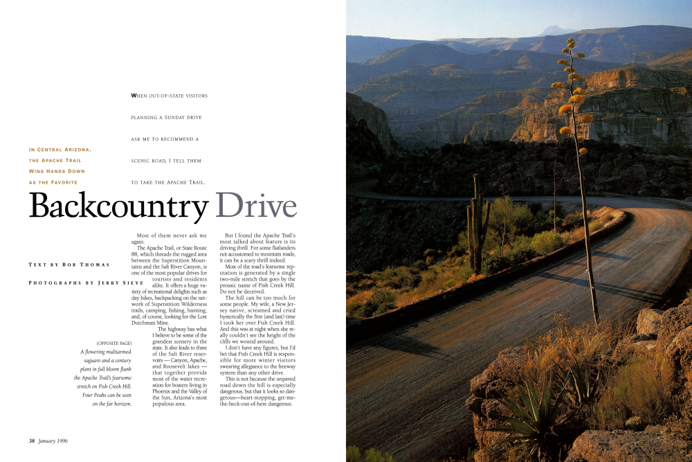
Most of them never ask me again. The Apache Trail, or State Route 88, which threads the rugged area between the Superstition Mountains and the Salt River Canyon, is one of the most popular drives for tourists and residents alike. It offers a huge variety of recreational delights such as day hikes, backpacking on the network of Superstition Wilderness trails, camping, fishing, hunting, and, of course, looking for the Lost Dutchman Mine. The highway has what I believe to be some of the grandest scenery in the state. It also leads to three of the Salt River reservoirs - Canyon, Apache, and Roosevelt lakes - that together provide most of the water recreation for boaters living in Phoenix and the Valley of the Sun, Arizona's most populous area. But I found the Apache Trail's most talked about feature is its driving thrill. For some flatlanders not accustomed to mountain roads, it can be a scary thrill indeed. Most of the road's fearsome reputation is generated by a single two-mile stretch that goes by the prosaic name of Fish Creek Hill. Do not be deceived. The hill can be too much for some people. My wife, a New Jersey native, screamed and cried hysterically the first (and last) time I took her over Fish Creek Hill. And this was at night when she really couldn't see the height of the cliffs we wound around. I don't have any figures, but I'd bet that Fish Creek Hill is responsible for more winter visitors swearing allegiance to the freeway system than any other drive. This is not because the unpaved road down the hill is especially dangerous, but that it looks so dangerous-heart-stopping, get-methe-heck-out-of-here dangerous.
THE APACHE TRAIL I LOVE TO DRIVE THE OLD ROAD, NOT ONLY FOR ITS CHALLENGES BUT BECAUSE IT IS THE QUICKEST WAY TO REACH REAL WILDERNESS, WILDERNESS MADE MORE PRECIOUS BECAUSE IT IS WITHIN 50 MILES OF A METROPOLITAN AREA OF NEARLY 3 MILLION PERSONS.
I've been over the road many times. This time, with a passenger who has never traveled it before, I start down Fish Creek Hill and casually point out the cliff whose beginnings can be seen through the windshield. He nods but doesn't seem terribly impressed. But the immensity of the chasm is not visible until after a sharp right turn. Suddenly he's very impressed. Sitting bolt upright, his right foot instinctively pumps an imaginary brake. We are confronted with a very narrow, twisting dirt road that clings to the side of this awful 1,000-foot cliff. The road has no shoulder and no protection except for an antique single-strap guardrail planted at the very edge of the abyss. Far below, as the road continues toward Apache Lake, we can see tiny cars and trucks made toylike by the great height. Going up or down and going up can be more frightening because your vehicle is closest to the cliff edge I can almost count on seeing other drivers, white-knuckled first-timers, staring fixedly ahead, feet riding the brake pedal, and driving square in the middle of the road. I think the worst traffic jam I ever saw on the hill was caused by two huge motorhomes, one coming down and the other going up. The drivers, both tourists, froze and eventually surrendered their steering wheels to more experienced drivers among the backed-up vehicles that stretched from the bottom to the top of Fish Creek Hill. The rescuers managed to squeeze the two behemoths by each other, but it was so close that the outside rear-view mirrors had to be folded back. Why not improve the Apache Trail and make it safer? Because it is no longer possible. The roadway, built between 190305 so that supplies and machinery could be hauled to the site of Roosevelt Dam, has been declared a historic Arizona road, which by law means that it cannot be widened, paved, or rerouted. Before this designation, about half of the road, from Apache Junction to Tortilla Flat, was paved. The rest remains dirt, graded and maintained by the Department of Transportation, but still washboardy and dusty. When the Apache Trail was constructed, for the then-shocking cost of a half-million dollars, the builders had no power machinery. It was hand labor, horse power, and dynamite all the way, following the contour of the land to search out the easiest grade and making a minimum of cuts through the tough granite ridges. But they built well, and the stone walls that support the road can still be seen at nearly every turn. At Fish Creek Hill they got lucky. A string of talus from age-old rockfalls had accumulated in a diagonal pattern on the face of the cliff. Blasting and shoveling, workers cut a gash across and down the cliff. Gaps in the talus slopes were filled with masonry walls. The road was barely finished before heavy high-wheeled freight wagons pulled by 20-mule teams were hauling supplies to the dam builders. I can imagine, as I drive Fish Creek Hill in a modern automobile, what it must have been like for those early drivers relying on 20 mules to brake wagons holding tons of freight. And in those days, there were no guardrails on Fish Creek Hill. Later the road was extended from Roosevelt Dam to Globe. For years it remained the only road from Phoenix to eastern Arizona.
I love to drive the old road, not only for its challenges but because it is the quickest way to reach real wilderness, wilderness made more precious because it is within 50 miles of a metropolitan area of nearly 3 million persons. Tremendous vistas can be seen from nearly every curve. There are many turnouts along the highway, most of them small and rocky, where motorists can park, walk over a nearby ridge, and see great canyons with yellowish rocks coated with green lichen, saguaros and other cacti, and, in certain places, breathtaking views of blue lake waters. At Apache Lake Marina, where many tourists stop to regroup, the conversation is almost always about the road. In the restaurant, I stop at the table of a couple who say they are from Ohio and ask them how they liked the drive.
"Oh, the scenery is just wonderful," said the woman. "But I didn't see a thing on that hill. I just shut my eyes and prayed.
THE APACHE TRAIL
I couldn't look. I just couldn't. We're not going back that way, are we, dear?"
Her husband, both hands gripping a can of soda so tightly that he wrinkled the metal, stared out the window for several seconds before answering. "Not likely," he finally said.
Super Bowl Visitors Guide:
For more about things to do and places to see around Arizona as well as tips on shopping, dining, nightlife, events, gaming, and golf in the Phoenix area, pick up a copy of the Super Bowl XXX Visitors Guide, produced by Arizona Highways in conjunction with Phoenix Magazine. The guide costs $7.95 and is available at retail outlets where magazines are sold. Or it can be ordered (plus $3.50 for postage and handling) by calling toll-free (800) 543-5432; (602) 258-1000 in the Phoenix area or outside the U.S.
WHEN YOU GO
The Apache Trail, State Route 88, can be reached from Phoenix on the Superstition Freeway (U.S. Route 60), exiting at Idaho Street in Apache Junction. Follow the signs north.
To drive to Roosevelt Lake and back takes an entire day, although the Apache Trail is just 22 miles long. Many curves and hills are limited to 10 and 15 mph. Apache Trail is paved to Tortilla Flat and dirt from there to Roosevelt Dam.
The dam is currently being raised and strengthened, and construction work requires closure of Apache Trail at the dam weekdays. The road is usually open on weekends, but check with the Department of Public Safety before leaving, 262-8011.
At the dam, travelers have the option to make a loop drive via Globe (State 88) or to take State 188 west to the Beeline Highway (State 87). Both routes are paved all the way to Phoenix.
What to see and do:
Even before reaching the road - which for practical purposes begins at the Tonto National Forest boundary - visitors may want to tour Lost Dutchman State Park, (602) 982-4485, or Goldfield Ghost Town, (602) 983-0333. The park is in the very shadow of the Superstition Mountains, and the ghost town is an extensive tourist attraction with restaurants, shops, snack food, a "mine tour," and helicopter rides.
The first half of the road, the paved portion, traverses a rough, rocky, exceedingly broken terrain while the second half consists of gravely soils on the sides of huge canyons. Canyon Lake, 14 miles from Apache Junction, is a spectacular sight from the road. There are campgrounds, picnic areas, a restaurant, boat launching ramps, steamboat rides, swimming beaches, and hiking trails. For information, call (602) 944-6504.
Tortilla Flat, the end of the paved road, is a well-known tourist stop with a post office, restaurant, saloon, motel, gift shop, and grocery store. The Old West theme is garnished by dollar bills that tourists have thumbtacked to the walls and ceilings of the restaurant and saloon as a way of leaving their mark. A large Forest Service campground is across the highway. For camping information, contact the Mesa Ranger District of the Tonto National Forest, (602) 379-6446.
Ten miles from the end of pavement sits Apache Lake. But to get there, motorists must first negotiate infamous Fish Creek Hill. There are signs announcing the hill, and at the top is a turnaround for those unwilling to try it. At the base is Fish Creek (yes, it has fish in it), marked by a single-lane bridge above a deep pool of water. On the right, upstream, is a smoke-blackened rock shelter used by early Indians. Downstream, cottonwood trees and other riparian growth make the running stream a popular place to explore or picnic.
Apache Lake Marina, reached by a steep dirt road, has a restaurant, groceries, bar, boat rentals (limited), a boat-launching ramp, motel, and camping sites. To inquire, call (520) 467-2511. Uplake is the Burnt Corral Forest Service campground. Contact the Tonto Basin Ranger District of the Tonto National Forest at (520) 467-3200. The road, from the marina to Roosevelt Dam, is seldom out of sight of Apache Lake, but access to the water is very limited except for a few dry washes. Trailheads in the Superstition Mountains include First Water, Tortilla, and Reavis Ranch. For more information, contact the Tonto National Forest office, (602) 225-5200.
Already a member? Login ».