
By the time I met Bob Stevens in December along a very muddy road on White Mountain Apache Tribe land, I’d been trying to get to the headwaters of the Salt River for six months. And if I were to count how long I’d been wondering about the place, it was a quest that extended over nearly three decades.
When I first moved to Phoenix in the mid-1990s, my primary contact with the Salt was driving over its dry riverbed before Tempe Town Lake was built. I also ran along the Arizona Canal, where the Salt’s natural flow had been channelized to provide water to growing cities in the Valley of the Sun. I kayaked the cool waters of the river’s lower section in the spring, and whenever I ventured up U.S. Route 60 from Globe, it was hard to keep my eyes on the road as I gawked at the beauty of Salt River Canyon’s towering cliffs.
While the Salt is well known for its canals, reservoirs and recreation — all of which contribute to the quality of life in the Phoenix metro area — the birthplace of this river was a mystery to me. Where was it? And what did the wild patch of earth that produced the water flowing into the homes of millions of desert dwellers look like? I asked my Arizona hiking buddies if they had ever visited the headwaters of the Salt. No one had. Then I studied hiking websites for information. There was nothing.
Last year, as unprecedented low flows on the Colorado River and a shrinking Lake Powell dominated the news, I became more fixated than ever on the Salt. This 200-mile-long river — coupled with its 194-mile-long major tributary, the Verde — is Arizona’s ace in the hole when it comes to water supply. A major source for the Phoenix metro area, it exists completely apart from the Colorado’s dwindling reservoirs.
The city of Phoenix gets 52 percent of its municipal water from the Salt and Verde, and Tempe gets a whopping 82 percent. While other Valley cities rely on lesser amounts, the rivers are critical to helping Arizona survive reductions in Colorado River allotments in the coming years. Yet the headwaters of these precious rivers exist in obscurity, virtually unknown and underappreciated by most Valley residents. I resolved to do my part to change that.
Months of phone calls and emails finally connected me with people who knew about the headwaters and could help me get there. For the Salt, it was Ramon Riley, the White Mountain Apache Tribe’s longtime cultural resource director; John Welch, an archaeologist who works with Riley; and Stevens, a San Carlos Apache Tribe member and experienced guide on tribal land. Stevens also is a supervisor for the tribe’s Language Preservation Program.
The remoteness of the location and lack of roads were just part of the challenge in accessing the Salt’s origin place. It’s an area of great cultural significance for Apaches, and it took some time to get the required permission for my pilgrimage, including a letter from San Carlos Apache Chairman Terry Rambler. But now, as Welch and I pulled up in his four-wheel-drive Toyota Tacoma to meet Stevens on the side of a road, there was one final hurdle: The last stretch of the journey was on a little-used dirt track that had been washed out during a recent storm. “I have a winch,” said Stevens, who was driving his own four-wheel-drive truck and had scouted the route a few days before. If the Tacoma got swallowed, he said, he could pull us out.
And so, we followed Stevens through the mud. The trucks climbed up and down gullies like bucking broncos. As I held onto the dashboard, I was struck by the disconnect between here and there — between where the Salt River first emerges in these mountains and where it fizzles out in the nation’s fifth-largest metropolis. I recalled what Riley had told me the previous day. “The skyscrapers in Phoenix get their water from our homeland,” he said. “There would be no Phoenix without our rivers.”
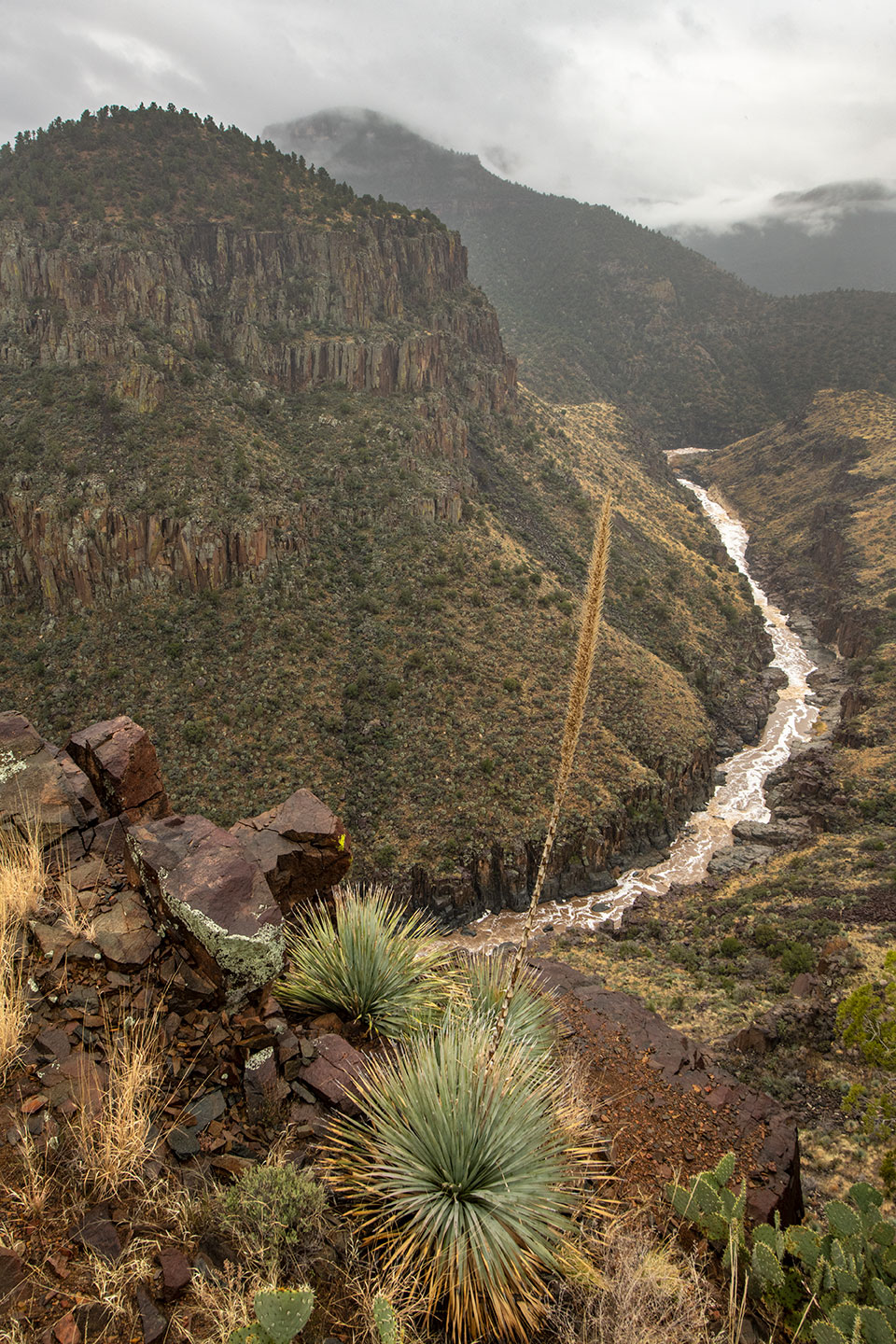
Rather than a single spring bubbling up from the ground, the headwaters of the Salt are a confluence where the White and Black rivers merge. The Black and Salt rivers form the boundary between White Mountain Apache and San Carlos Apache lands. These rivers are fed by springs and creeks in Eastern Arizona’s White Mountains and by snowmelt from 11,411-foot Mount Baldy, a peak sacred to Apaches, Hopis, Navajos, Zunis and other tribes. From the confluence, the Salt pulses west through knife-edged cliffs and picks up more water from Cibecue, Carrizo and Canyon creeks as it drops some 3,000 feet to the Valley floor, where it joins the Verde.
The headwaters of these precious rivers exist in obscurity, virtually unknown and underappreciated by most Valley residents. I resolved to do my part to change that.
Before European immigrants arrived in the Salt River Valley, the ancient Hohokams and then the Salt River Pima-Maricopa people farmed the fertile soils in what was a rare desert oasis. Meanwhile, the Ndee, or Western Apaches — ancestors of today’s White Mountain Apache, San Carlos Apache and Yavapai-Apache tribes — lived throughout the Salt and Verde rivers’ 13,000-square-mile watershed in present-day Central and Eastern Arizona. They “mapped” their lives onto their lands, thriving by farming along creeks, foraging and hunting in places of seasonal abundance, and traveling from one spring to the next.
“We have always lived in these mountains,” Riley says of the White Mountain Apache Tribe’s relationship to Mount Baldy and the rivers connected to it. “We believe the creator put us in this beautiful spot so we will have an eternal source of water. It sustains everything from ‘creepy crawlers’ to human beings.” The Apache name for the Black and Salt rivers extending from Mount Baldy to the Salt River Valley is Tu Diłhił, which means “black waters.” The White River is called Tu Dotł’izhi, which means “blue waters.”
In the early 1870s, as more European-American settlers moved into the Salt River watershed, the Western Apaches were forced to reside on the 1.6 million-acre Fort Apache Reservation and the adjacent 1.8 million-acre San Carlos Apache Reservation, which represented less than a quarter of their homeland. While settlers and the U.S. government were interested in claiming the rich timber and mineral deposits in Apache territory, the rugged confluence where the Salt River began was not on their radar. “The federal government had no idea what was there,” says Welch, who is a professor at Simon Fraser University in Canada and has authored numerous articles on Western Apache history. “The upper Salt River was just a jumble of rocks to them.”
Hundreds of miles downstream, however, a small farming community of European-Americans was taking shape in the Valley, and they wanted a predictable irrigation source. In 1906, the newly created U.S. Reclamation Service, which later became the Bureau of Reclamation, began construction on Theodore Roosevelt Dam to harness the Salt River’s abundant and often-erratic flow. When the project was dedicated in 1911, the 280-foot-tall masonry plug in the Tonto Basin was the largest dam in the world. And Theodore Roosevelt Lake became, at the time, the largest artificial lake on the planet.
In the following decades, three more dams were built on the Salt River below Theodore Roosevelt Lake, creating Apache, Canyon and Saguaro lakes. And below these reservoirs, two diversion dams and two canals were constructed to funnel the Salt River’s water to the Phoenix area. Two more dams were built on the Verde River above its confluence with the Salt, creating Horseshoe and Bartlett lakes. In addition to providing reliable water to the Valley’s burgeoning desert cities, the dams generated hydropower that supplied electricity to the Valley, facilitating air conditioning and other improvements.
The dams and related infrastructure have been managed since 1903 by the nonprofit Salt River Project. Today, SRP remains the largest electricity provider in the Valley and delivers more than 244 billion gallons of water to the Phoenix metro area every year. About 60 percent of SRP’s surface water comes from the Salt, while 40 percent comes from the Verde. “Most cities [in the Valley] have been able to grow and thrive thanks to SRP water,” says SRP spokesperson Patty Garcia-Likens.
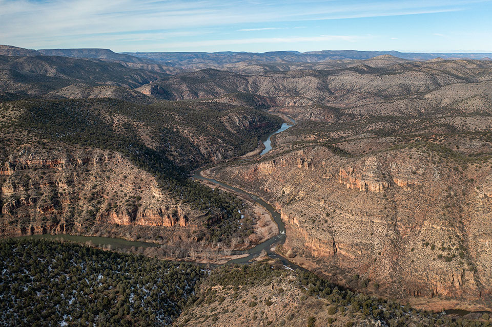
But the bustling Valley is a world away from the Salt’s rugged headwaters. After surviving the muddy drive without getting stuck, our two-truck caravan reached a juniper-covered ridge sitting high above the confluence of the Black and White rivers.
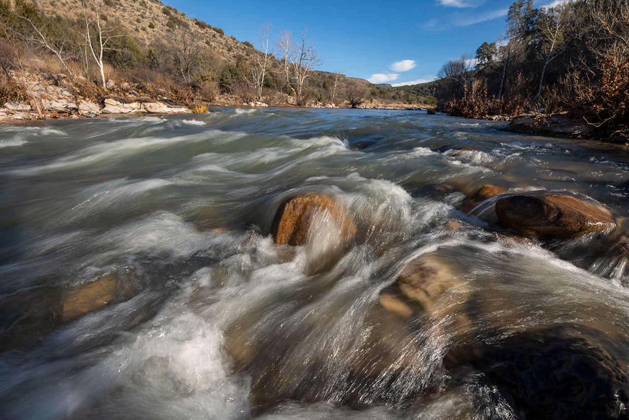
Welch, Stevens and I got out of our vehicles to take in the view. The Black River, a twisting ribbon of green glinting in the sun, sat a thousand feet below us on one side of the ridge. On the other side was the serpentine White River. And off the tip of the ridge was the place where the rivers merge to produce the Salt. Roaring Class III rapids on the Salt’s first half-mile were audible even from our high perch.
The rivers are tucked between deep cliffs that resemble a miniature Grand Canyon, with ivory layers of limestone sitting atop sheer burnt orange cliffs. Except for a single dirt track on San Carlos Apache land to the south, these tribal lands remain unbroken wilderness as far as the eye can see. In fact, the terrain is so steep and trail-less that we decided it would be foolhardy to try to hike down to the confluence. We were content to enjoy the spectacular view from the ridge.
“We believe the creator put us in this beautiful spot so we will have an eternal source of water. It sustains everything from ‘creepy crawlers’ to human beings.”
— Ramon Riley, White Mountain Apache Tribe
“We have a strict belief that we should not disturb the land,” Stevens says of traditional Apache culture. “We are still very connected to the land, even though many outsiders don’t realize that. We believe that the more you disturb the land, the more you disturb your soul and you will lose who you are.”
The week after my visit, I ventured to the Verde, the Salt’s sister river, and witnessed a very different situation. The Salt and Verde are like the left and right chambers of a heart: Each is unique but equally vital to keeping Arizona’s natural waterworks healthy. Unlike the Salt watershed, which is mostly on undeveloped Apache and national forest lands, much of the Verde watershed is on private property. There, the land faces some of the greatest development pressures in the state.
Although the 6,600-square-mile Verde watershed is the traditional home of the Yavapai and Dilzhe’e (Tonto) Apache peoples, virtually all of their land was claimed in the 19th century by European-American settlers drawn to the region for its fertile soils and rich mineral deposits. In 1909, the federal government purchased 18 acres near Camp Verde to establish a tiny Yavapai-Apache reservation, later expanded to its current 642 acres.
Over the past several decades, development in the Central Arizona cities of Prescott, Prescott Valley and Chino Valley has resulted in unprecedented groundwater pumping from aquifers that feed the upper reaches of the Verde. Back in 1950, there were 226 wells in the Verde Valley that drew from these aquifers, according to SRP data. Today, there are some 9,000 wells in the river valley and many more in the larger watershed. Del Rio Springs, the historical headwaters of the Verde, now has a tenth of its original flow as a result of groundwater pumping. And a 6-mile section of the uppermost stretch of the river has dried up.
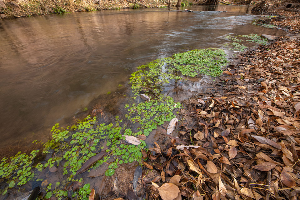
The perennial flow of the Verde now begins in an isolated riparian oasis called Verde Springs, which is mostly located in the Upper Verde River Wildlife Area, an Arizona Game and Fish Department site about 6 miles southeast of Paulden. I visited the site with Gary Beverly, a tireless protector of the headwaters.
“The flow of the river has been significantly reduced, but it is still a functioning ecosystem,” Beverly said as we stood on the Verde’s banks, where a multitude of springs pushed through the ground to birth a stream. Even in December, the river was lush. Bright green moss hung onto rocks beneath the swift, clear waters. Lily pads lined the river’s edge, along with a forest of cattails that were stiff and yellow in their winter dormancy. Ancient cottonwoods, too large for their own good, and clusters of winter-bare willows dominated the sandy banks.
Beverly has lived in Chino Valley since the mid-1970s and is the chairman of the Sierra Club’s Yavapai County chapter. He talks about Verde Springs and the entire river as if he’s bragging about his grandchild. Even though the Verde watershed occupies just 5.8 percent of Arizona’s land mass, it provides critical habitat for three-quarters of the state’s wildlife species, according to Beverly. This includes 18 species that are federally listed as endangered or threatened, plus 16 others that the Prescott National Forest or Game and Fish considers sensitive species or species of concern, respectively.
Signs of wildlife were everywhere during our visit: an eagle’s nest in the crook of a cottonwood, deer tracks in the sand, stumps chewed by beavers, birdsong above our heads. We walked downriver as the Verde picked up momentum, the flow boosted by recent rain and snow and the magic of water emerging from an ancient aquifer. The springs extend for several miles in the river channel and are considered a sacred life force by the Apaches, who call Verde Springs Tu Cho Ha Li’in, or “big water bubbling up.”
According to ecologist Larry Stevens, the water bubbling up from these springs and other Verde Valley sites arises through complex flow paths with local and long-distance sources. That means the water could be from a recent rain, or it could be from a time when woolly mammoths walked the land. The fractured geology along the Mogollon Rim creates a subterranean maze of chambers and channels holding the aquifer’s water. “There are some very long, elaborate flow paths of water in which a snowflake can melt and pass into the ground on the San Francisco Peaks, and it then passes down through 4,000 to 5,000 feet of strata and comes out 13,000 years later at Montezuma Well, for example,” Stevens says.
Montezuma Well, in the middle section of the Verde and managed by the National Park Service, is the place where the Yavapai people believe they emerged into this world. Stevens says it also has the highest concentration of unique species — meaning those that exist nowhere else — of any single place in North America. “These spring ecosystems are just off-the-charts incredible,” says Stevens, who has spent five decades studying springs and water sources in the Southwest, particularly in the Colorado and Verde river drainages, for the Museum of Northern Arizona and through his nonprofit Springs Stewardship Institute. The latter group works to raise attention among Verde Valley residents about the ecology and importance of the nearly 900 springs that provide the Verde’s base flow.
The idea of 13,000-year-old water flowing into a swimming pool in Chino Valley — rather than into the headwaters of the Verde, as nature intended — is disturbing to Beverly and many other activists advocating to protect the watershed. Beverly is part of a grassroots effort, supported by national conservation groups, to have Verde Springs and the upper stretch of the Verde federally designated under the Wild and Scenic Rivers Act. He’s also hopeful about limiting groundwater pumping in the upper Verde watershed, and SRP is working with Prescott and Prescott Valley to ensure that pumping will not affect Verde Springs.
“The Verde is a green artery pulsing through the heart of Arizona,” Beverly said as we climbed up a rocky ridge and looked down into the deep river canyon. “We have to keep the water in the river.”
Even though the Verde watershed occupies just 5.8 percent of Arizona’s land mass, it provides critical habitat for three-quarters of the state’s wildlife species.
Once I returned home from my trek with Beverly, a large winter storm settled on Arizona, and it was followed by an even bigger precipitation event. At one point in early January, the flow through Salt River Canyon went from a placid 275 cubic feet per second to more than 16,000 cfs — significantly higher than the Colorado River flow through the Grand Canyon at the time.
“We have received more runoff into the reservoirs in the first five days of 2023 than the entire runoff season of 2018,” Likens, the SRP spokesperson, told me. She added that, unlike the perpetually overdrawn Colorado River system, SRP’s reservoirs can be filled by one wet winter.
As the snow piled up on my own roof, I thought about the faraway headwaters. Perhaps they were having the equivalent of a raucous New Year’s party, drenched in rain and mud for days. And it seemed that a prediction from Larold Dazen, with whom I’d visited when I was on White Mountain Apache Tribe land, might be coming true. Dazen is a traditional practitioner and manager of the tribe’s community farm, which irrigates its crops with water from the White River.
“My ancestors knew how to predict the weather without being meteorologists,” he said. The tribe had suffered from drought over the past decade and was forced to cut back on water use, but Dazen said he believes things are changing: Last summer, remembering what his ancestors had taught him, he saw flowers that foretold that a wet winter was coming.
“Mother Nature has been rejuvenating herself and making things new again,” Dazen said, referencing the tribe’s combined hardships of drought and COVID-19. “When she brings back the rain and snow, our fields will have plenty. Water is always a blessing to our people.”