We were camped in a narrow corridor of black cliffs that actually felt like a box, but it hardly felt claustrophobic. A whisper of breeze carried the rich, muddy scent of the river. Wispy clouds turned orange over a narrow slice of sky as daylight slowly filled the atmosphere. A cacophony of birdsong emanated from a curtain of greenery behind camp, building in intensity along with the coming light. It all felt very tropical.
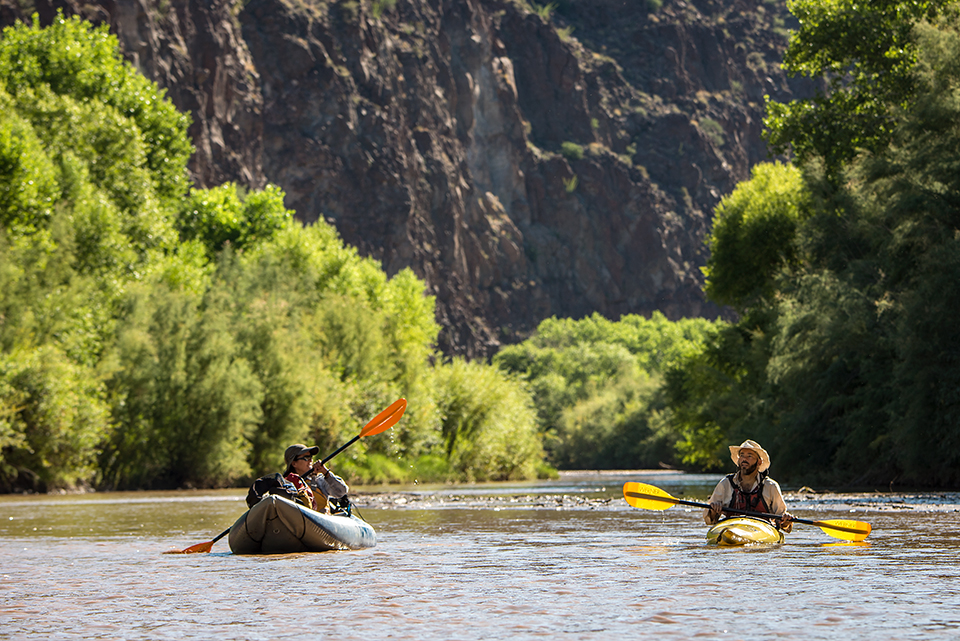
Three of us — Melanie Bell, a university biostatistics professor; her husband, photographer Bill Hatcher; and I — had convened at the Gila River without any visions of a tropical getaway. This was a desert river, and that title in itself was sort of an oxymoron, so we didn’t know what to expect. I hadn’t floated the Gila in decades, and that was on the receding waters of a flood, when the restless river roiled across its wide bed, filling the canyon bottom, covering the bushes and some of the trees, swiftly ushering me through a wide desert landscape — or so I recalled. This time was bound to be different. When I left my house in Flagstaff, the Gila River gauge read 89 cubic feet per second — about enough water to lubricate a gravel bar, but not enough to actually cover it.
My first glimpse of the “river” along U.S. Route 70 west of Safford revealed no water at all, just a sandy, brush-filled lowland shimmering in desert heat. Rows of cotton, green and productive, soon lined the highway, offering some explanation for the dry riverbed below. This is the Gila most of us see: an emasculated ghost river offering its last trickle to agriculture. At Florence, and farther downstream where it passes beneath Interstate 10, the Gila is usually waterless. Upstream from Safford, however, the scene changes. My next glimpse of the Gila was here, and it was significantly more encouraging. Beyond the cotton fields, the river snaked along, golden brown with recent runoff. This was good news.
We’d been spared a low-water kayak drag-fest by a random return of monsoon rain. It wasn’t high water by any stretch, but it would be enough to sluice our one-man boats through the cobbles. The rain hadn’t fallen nearby. There was no scent or sign of a recent storm, but distant blue highlands offered a clue. As the crow flies, the Gila’s source was only 70 miles away, and that was plenty of terrain to gather a downpour within this rich, rugged corner of the Southwest.
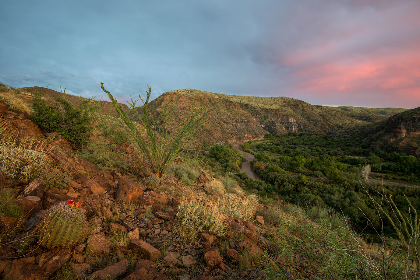
The Gila begins among spruce forests atop New Mexico’s 11,000-foot-high Mogollon Mountains, just across the state line from Arizona’s White Mountains. It races through canyons of compressed volcanic ash laced with cliff dwellings, twists through miles of rugged and blocky hills covered in oaks and pines and junipers, and empties into a bucolic valley peopled by old-time settlers and New Age farmers before plying another range of mountains in a series of rapids that New Mexicans call “the box.” Shortly after crossing the indecipherable Arizona border, the river carves Arizona’s Gila Box. Here, the little waterway hides beneath ridges of crumpled desert grassland in a canyon of secluded grottoes. This 25-mile stretch of wildness above Safford is the final crescendo of the upper river, the last place where water still flows before succumbing to irrigation canals and scorching desert sands. In effect, the Gila Box is the last piece of the living Gila.
The river’s nourishing liquid has served as a travel route for as long as humans have walked the Southwest. The Hohokams, the Salados and other ancient peoples left archaeological evidence near the Gila. Francisco Vázquez de Coronado crossed the river in his quest for the Seven Cities of Gold in the 1540s, but his cumbersome army avoided the Box. Three centuries later, General Stephen Kearny’s troops begrudgingly traversed the slopes above the Box en route to California, dubbing the route “the devil’s turnpike.”
At that time, 1846, much of the Gila formed the border between the United States and Mexico. From its confluence with the Colorado River at Yuma, the international boundary followed the waterway upstream, finally departing the river on a line of southerly longitude at the mouth of the Box. Above here, the river was mostly unknown. In 1854, the Gadsden Purchase moved the international border south to its present location, and broader European settlement near the Gila began to take hold in the following decades. The residents of Safford established an effective network of diversions just below the Box, and they soon learned the difficulties of harnessing this capricious river. The Gila, diminutive as it might be, can sometimes rage.
In 1905 and 1906, floods forced residents to rethink irrigation strategies. In 1916, floodwaters registered 100,000 cubic feet per second (cfs), a flow larger than the Colorado River carried during its spring freshet. Then came a relative respite until the 1970s, when several high-water events occurred. The biggest Gila flood since settlement came in 1983, after an October hurricane remnant that tracked right through the Gila’s headwaters. The winter of 1993 produced another big flood, but since then the really big flows have been more limited. The highest water this century was a measly 38,000 cfs, in 2005.
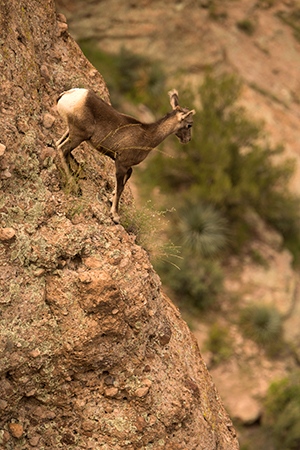
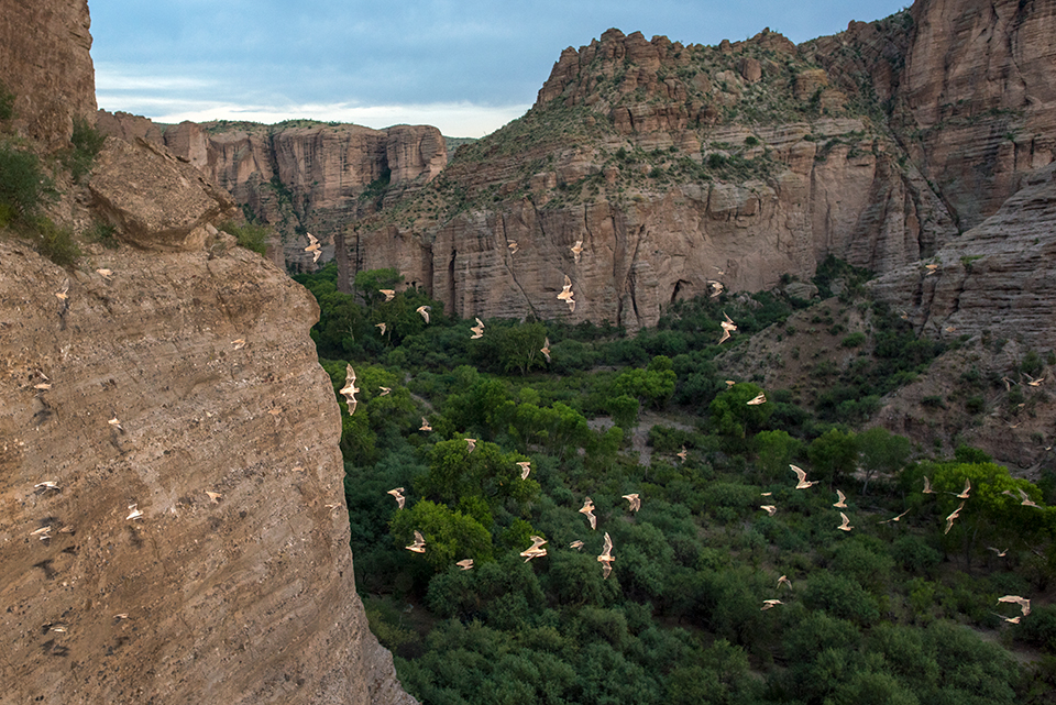
Even a flood of this magnitude produces massive silt deposits along the Gila, which in turn provide ample footing for a menagerie of vegetation, birds and mammals. More than 200 species of birds use the corridor, just one reason the Gila Box is a national riparian conservation area. A black hawk circled overhead as we rigged our boats, and a great blue heron glided low and gracefully over the water.
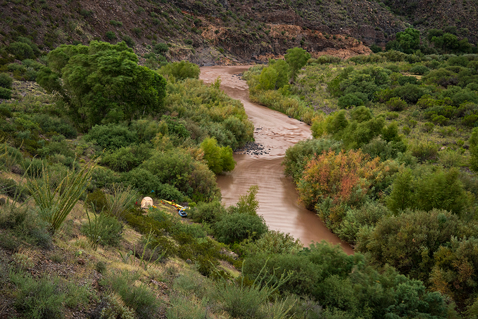
Sleeping bag, pad, tent, lunch bag, dinner bag, clothes bag ... Bill and Melanie secured it all into their open inflatable kayaks, while I stuffed the insides of my plastic boat, beneath a picturesque bridge that has stood since 1918. A slightly more modern version of Kearny’s turnpike, the old Clifton-to-Safford road is today’s Black Hills Back Country Byway — a lonely, winding strip of plowed dirt offering a wonderfully slow and bumpy ride to the isolated Gila. Scenic as it was, we were happy to leave the dusty ride behind and ease onto a new road, one of quiet, mocha-brown flowing water.
The river coursed through a ribbon of green that seemed to create an environment entirely autonomous from the sparse desert above. Thick-spreading cottonwoods, dense and wavering willows, tree tobacco plants full of yellow bell-shaped flowers … they all overhung the narrow river, sometimes making a tunnel of vegetation that we drifted into slowly, cautiously, as if an anaconda might dangle from a limb at any moment.
One tree noticeably scarce in the riparian jungle was tamarisk. Imported from the Middle East in the 1800s, this riverine tree found its new home in the American West perfectly suitable, even ideal. Today, it’s rare to travel a desert river in the United States without seeing thickets of thirsty tamarisks crowding the banks. In many locales, the willowy tree has taken over the habitat, creating dense, impenetrable hedges where open floodplains of willows and cottonwoods once existed. In the Gila Box, however, tamarisk is only a minor player within the river forest. Aesthetically, it seems to complement the native species with its feathery fronds and purple flowers.
Tamarisks are kept in check here, partly due to the river’s regular floods — nature’s housecleaning. Native vegetation withstands the torrents, maintaining a shade canopy that inhibits tamarisk growth. With no dams upstream to regulate the flow (the first Gila dam, Coolidge, creates San Carlos Reservoir 60 miles below Safford), the upper Gila maintains naturally random cycles of flood and drought. Diversions above the Box have some impact, mainly making times of low water — such as the 89 cfs we were anticipating — even lower.
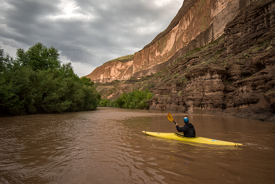
Still, the wild Gila can change with little warning. Melanie was escaping the afternoon heat, floating in the water beside her boat under a royal blue sky, when I made a weather-wise comment about high pressure subduing the monsoon. Minutes later, the sky massed with billowing white clouds, throwing dark shadows. A powerful gust sprang a dust devil to life along the open floodplain. Cottonwoods trembled boisterously. A few raindrops wetted river cobbles, bringing their various colors to life momentarily before they quickly dried back into a uniform paleness. We kept floating, thinking that the gathering storm might be just a tease. A nearby crack of lightning quickly changed our opinion.
We scrambled to shore and pursued different electrocution survival strategies. Bill sat in his rubber inflatable, exposed to the coming rain, while Melanie and I cowered ineffectively beneath willows. She sat on her personal flotation device. I rested on a plastic camera box, just one foot on the ground so as to not allow a full circuit of electricity to go in one foot and out the other in case of a nearby ground strike.
The hard rain approached in silver sheets, plummeting in five-second bursts as if flung from some unseen force in the sky. Downstream, the drops washed across rocky outcrops, bouncing upward to be swept away by the wind in clouds of gray spindrift. It came in waves like this for 45 minutes before settling into a gentle rain. Soaking wet, we all sat on Bill’s boat and shared a beer.
The sudden drop in temperature, from 90 degrees to 70, caused the Gila to magically turn into a hot-spring river. Of course, this was simply a function of relativity. When the air was a dry 95 degrees, the water felt pleasantly cool. Now that it was a damp 70 degrees outside, the 80-degree river felt distinctly warm, almost hot.
Dipping my chilled feet into the Gila brought instant relief, like stepping into a warm bath. I paddled that way, feet dangling out of my kayak in the tepid stream, as a mist rose around us beneath the Orange Cliffs, a band of volcanic tuff curving over a river bend. Lichens streaked down the wall, popping lime green in the misty half-light.
Fearing a rise in water level from thunderstorms that still rumbled in the distance, we pitched our camp 20 feet above the water, surrounded by spiny desert plants like ocotillos and agaves. We talked about how the Gila Box differed from our expectations, as loose as they might have been. I decided it was completely different than my recollections from the last trip, and we agreed that given the water levels and seasons, it might be a different place on every visit. I took comfort in that.
Bill sprinted off to capture a developing rainbow that arched over the hills behind us. Meanwhile, I stood in the wet sand and looked down at the Gila’s green corridor, listening to its gurgling flow, grateful for the magical sound of flowing water in the desert.