
The road to Bisbee follows the feet of mules. Old photographs show ore-laden wagon trains crawling over the steep mountain pass. In the 1880s, mule skinners had to pause at the top to pay a toll (10 cents for every man and mule) before descending into town.
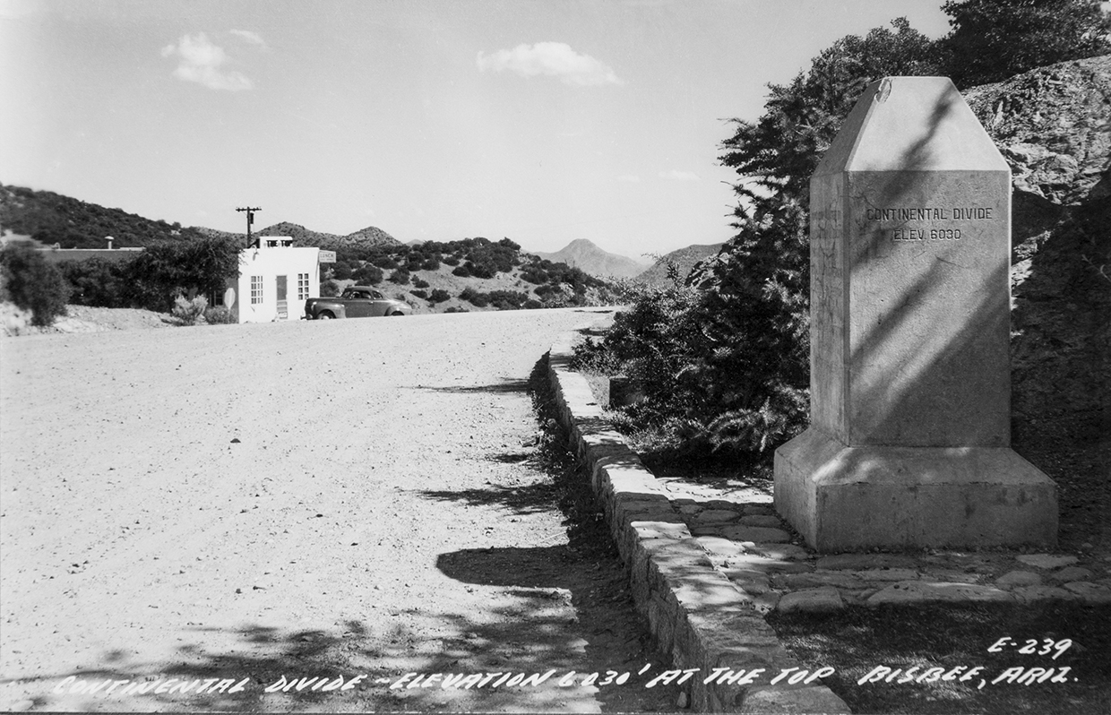
The old road still exists, paved now but twisty as ever. Most visitors don’t come that way. The opening of the Mule Pass Tunnel in 1958 offered a quicker, safer route through the mountain, instead of over it. But the original road appeals to me. For one thing, it offers a stupendous view of the San Pedro River Valley, all the way to the hazy Huachuca Mountains. It’s also home to an oddity: a four-sided concrete obelisk tucked under a juniper.
The stubby monument announces the names of state and county politicians who took credit for improving the old mule trail into an automobile road. “ROAD CONSTRUCTED BY PRISON LABOR 1913-14,” read the block letters on the north face. But it’s the words on the west side that make the obelisk so strange. “CONTINENTAL DIVIDE,” they say. “ELEV 6030.”
A divide, in a hydrological sense, is a line on a map that separates one watershed from another. Landscapes are riddled with watershed divides, but there’s only one Continental Divide: a north-south line that cleaves North America and separates Western waterways (flowing to the Pacific Ocean) from Eastern counterparts (flowing to the Atlantic Ocean). The Continental Divide starts in Alaska and follows the spine of the Rocky Mountains, reaching the southern border at the bootheel of New Mexico. That’s right: New Mexico, not Arizona. The obelisk’s claim to fame is 100-plus miles off the mark.
The monument is located at a watershed divide: Banning Creek flows west off the ridge, while Mule Gulch flows east. I use the word “flows” as only someone in Arizona can, for these creeks are usually dry. Theoretical water in either one winds up in the same place: the Gulf of California.
Why the mistake, I wonder? Annie Larkin at the Bisbee Mining & Historical Museum says she’s baffled, too. “Given that Bisbee had some of the best geologists in the country at the time,” she writes to me, “they would surely have known where the Continental Divide was located.”
It’s hard to doubt words etched in concrete, so I’m not surprised the error has popped up in newspapers and magazines (including, alas, this one). Bisbee locals perpetuate the myth, tossing out references to “the other side of the divide” and “the Old Divide Road.”
After the obelisk, the road drops into Tombstone Canyon, and I follow it to the museum. Larkin has warned me the archives offer no clue to the obelisk’s origins, but I can’t resist a peek. Three volunteer historians — Mike Anderson, Ruben Gomez and Deloris Reynolds — pitch in to help.
Collectively, they remember a time when the top of the pass was a hotspot for travelers — and for young couples who parked there to enjoy … the view. Visitors dined at the Top Café and leaned on the obelisk to pose for photographs. The road was part of U.S. Route 80, a coast-to-coast thoroughfare from Georgia to California that was known as the “Broadway of America.”
“Everybody knows about Route 66,” Anderson says, “but Highway 80 was just as important, if not more so.” The latter just lacked the publicity of a Bobby Troup song.
I ask whether locals know the “divide” isn’t really the Divide. Gomez says, “Most current residents have no idea,” but people like himself, born and raised in Bisbee, are aware of the myth. “We take history very seriously,” Anderson chimes in. “Nostalgia is our product. Accurate nostalgia is history.”
An old letter in the archives, written by Reynolds to a staffer at the Arizona Department of Transportation, suggests the incorrect words wouldn’t be hard to obliterate. But they remain, and I’m no closer to the cause of the error. Was it a genuine mistake, or a joke? I have one last source to try. Terry Couchenour of the Cochise County Engineering and Natural Resources Department has found mentions of the “divide” on federal surveys as early as 1915. He says it’s not clear if the surveyors copied the monument, or if the monument, built later, copied the surveys.
“I think Bisbee is mostly at fault for this,” Couchenour adds. Advocates for the Good Roads Movement, which sought to improve rural roads for bicycles and automobiles, filled the town in the early 1900s. Maybe, Couchenour speculates, they dreamed up an outlandish claim to attract tourists. “We could have just made it all up,” he says.
It’s as good an answer as any. The obelisk’s origins remain a mystery, making it a fitting waypoint for a town that proudly straddles the divide between real geography and urban myth.
BISBEE Discover Bisbee, 520-432-3554, discoverbisbee.com