
On most mountain roads, the higher you go, the rougher the road gets. Carr Canyon Road, the only driving route to the upper reaches of Southern Arizona’s Huachuca Mountains, is no exception: What begins as a paved meander later becomes a steep, rutted and patience-testing climb. Luckily, the panoramic views and fascinating geology you’ll see along the way make it more than worth the effort.
From State Route 92 just south of Sierra Vista, head west on Carr Canyon Road, built around 1900 and rebuilt in the 1930s to provide access to gold, silver and tungsten deposits in the Huachucas. After 1.3 miles, the pavement ends as you enter the Coronado National Forest and begin your climb into the mountains. The Carr Reef, a thick band of sheer, lichen-stained cliffs on the Huachucas’ eastern face, looms overhead. You’ll get a much closer look at these cliffs later on.
At Mile 2.2, just past a wash lined with tall sycamores, is the Carr House, a historic cabin that Friends of the Huachuca Mountains now operates as an information center; it’s open on weekends during the warmer months of the year. In this area, oaks, alligator junipers, yuccas and large agaves line the road, which gets rockier and narrows to one lane. Make note of the numerous roadside pullouts, in case you need to pull over so a car coming downhill can pass. (If there’s no pullout nearby, the car going uphill has the right of way.)
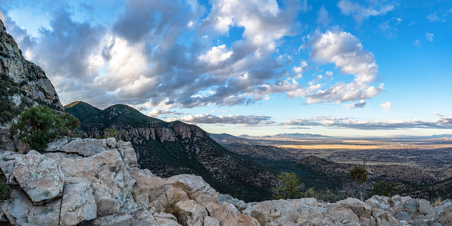
The road soon begins a series of switchbacks, and the sharp bends offer views of Sierra Vista and the San Pedro River Valley, along with the Mule Mountains to the east and the Dragoon Mountains to the northeast. You also can see Cerro San José, an isolated peak in Mexico, to the southeast. And a pullout at Mile 4.6 overlooks a waterfall that pours from the Carr Reef when there’s enough runoff. As signs warn, don’t get too close to the edge — you wouldn’t be the first to lose your life on the slick rocks.
About 5 miles in, you’ll start getting close looks at the reef and its greenish-yellow (or are they yellowish-green?) decorations of lichen. What follows is the road’s most challenging section: steep, rocky and deeply rutted. Take it slow, because this isn’t the place to puncture a tire or lose traction. The reward for your patience is at Mile 6, where another pullout looks down onto the sheer cliffs and the valley far below. If you have time for photos at only one overlook on this drive, make it this one.
From here, the road descends a bit as it cuts deeper into the mountains, and healthy ponderosa pines encroach on both sides. At Mile 6.4, you’ll come to a well-maintained campground where the mining town of Reef once stood. Mining in this area never was terribly successful, but Reef did grow large enough to have its own post office for a few years in the early 1900s.
The drive’s final stretch passes stands of tall, thick ponderosas before the road ends at Ramsey Vista Campground. From here, hiking trails lead to numerous destinations in the Huachucas, including 9,236-foot Carr Peak, the range’s second-highest mountain. Even if you aren’t hiking, the campground’s pines and oaks are so alluring that you’ll want to take your time. That goes for the return trip, too.
Tour Guide
Note: Mileages are approximate.
Length: 7.7 miles one way (from State Route 92)
Directions: From Sierra Vista, go south on State Route 92 for 6 miles to Carr Canyon Road (Forest Road 368). Turn right (west) onto Carr Canyon Road and continue 7.7 miles to Ramsey Vista Campground.
Vehicle requirements: A high-clearance vehicle, such as an SUV or truck, is required, and four-wheel-drive is recommended.
Special consideration: The Coronado National Forest closes the road when winter weather creates hazardous conditions. Contact the forest before your drive to ensure the road is open.
Warning: Back-road travel can be hazardous, so be aware of weather and road conditions. Carry plenty of water. Don’t travel alone, and let someone know where you are going and when you plan to return.
Information: Sierra Vista Ranger District, 520-378-0311 or fs.usda.gov/coronado; Friends of the Huachuca Mountains, huachucamountains.org