
It’s that time of year again, when we work to shatter the misconception that Arizona doesn’t have any seasons, including autumn. Watch this …
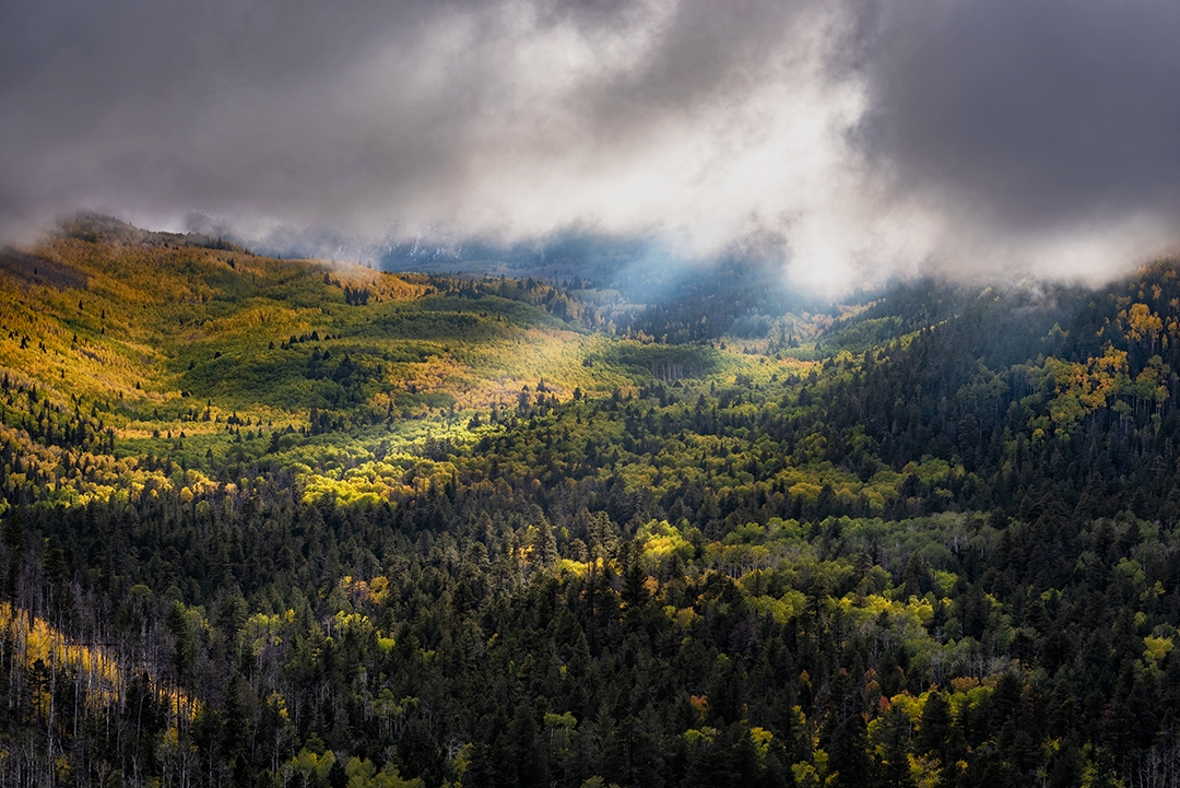
Sunlight streams through a break in the clouds and illuminates aspens and evergreens above Lockett Meadow, a popular camping and wildlife-watching destination on the east side of the Peaks. This view is from Sugarloaf Mountain, just northeast of the meadow. | Photograph by Douglas Koepsel
SAN FRANCISCO PEAKS
PEAK COLOR: Late September to early October
Directions: From downtown Flagstaff, go north on U.S. Route 89 for 16 miles to Forest Road 552, across from the turnoff for Sunset Crater Volcano and Wupatki national monuments. Turn left onto FR 552 and follow the signs for Lockett Meadow Campground. A high-clearance vehicle, such as an SUV or truck, is recommended.
Information: Flagstaff Ranger District, 928-526-0866 or fs.usda.gov/coconino
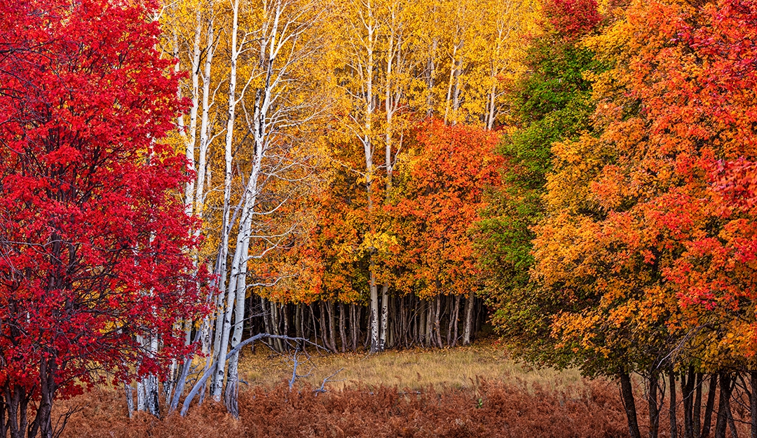
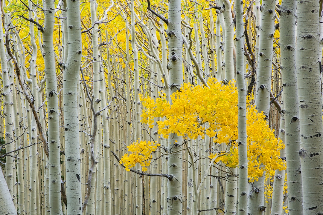 Tightly packed aspens display their autumn hues along the Inner Basin Trail in the San Francisco Peaks. This easy trail, which runs for 3.9 miles round-trip, traverses the interior of the collapsed stratovolcano that now forms Arizona’s highest mountain range. | Photograph by Tom Bean
INNER BASIN
PEAK COLOR: Late September to early October
Directions: The Inner Basin Trailhead is at Lockett Meadow Campground (see directions above).
Information: Flagstaff Ranger District, 928-526-0866 or fs.usda.gov/coconino
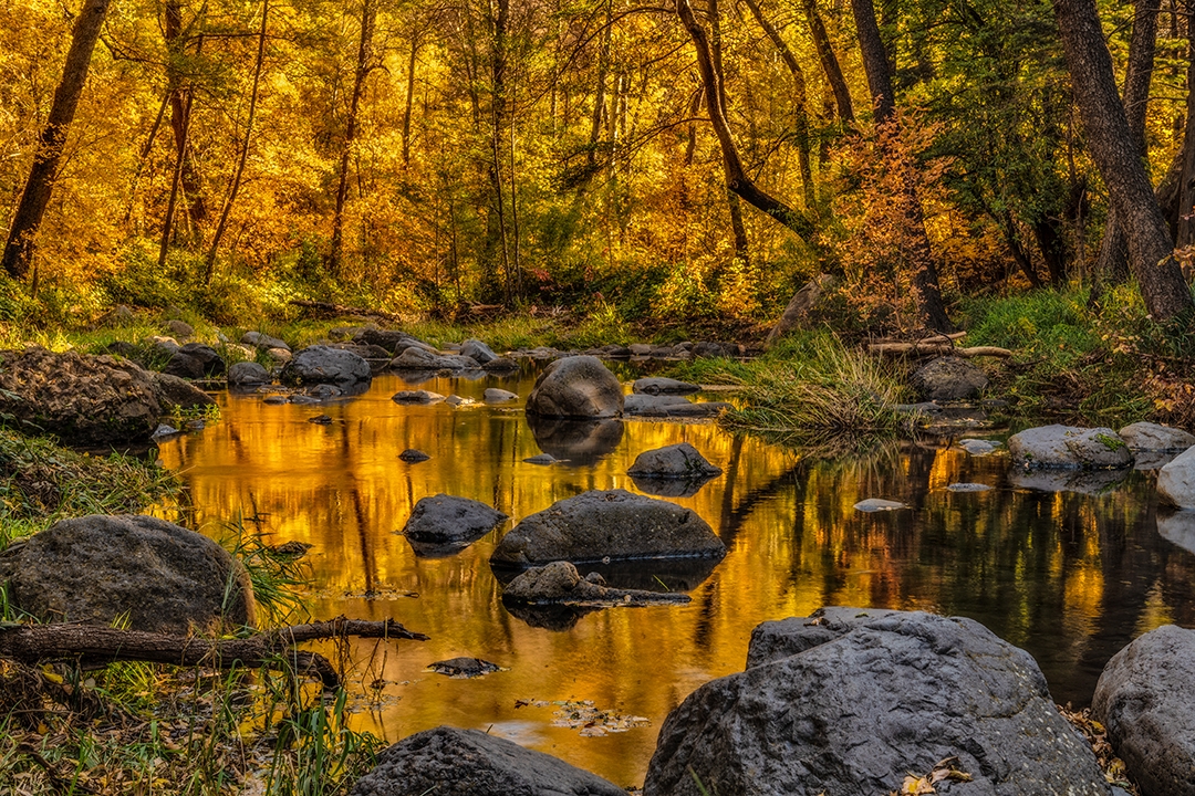 Fall foliage bathes serene Oak Creek, north of Sedona, in golden tones. A drive through the canyon or a hike on the popular West Fork Oak Creek Trail offers plenty of views of the oaks and maples that dominate the fall color season in this part of Red Rock Country. | Photograph by Guy Schmickle
OAK CREEK CANYON
PEAK COLOR: October
Directions: From Sedona, go north on State Route 89A for 16 miles to Oak Creek Vista. The entire route is paved.
Information: Red Rock Ranger District, 928-282-4119 or fs.usda.gov/coconino
 Maple leaves begin to don their autumn hues along State Route 366 (the Swift Trail), the main route up the mountain. Mount Graham is the highest peak in the “sky island” Pinaleño Mountains, which are home to an endangered squirrel species and numerous large telescopes. | Photograph by Paul Gill
MOUNT GRAHAM
PEAK COLOR: October
Directions: From Safford, go south on U.S. Route 191 for 7.3 miles to State Route 366. Turn right onto SR 366, which later becomes Forest Road 803, and continue 35 miles to the road’s end near Riggs Flat Lake. The first 22 miles of the route (from U.S. 191) are paved; a high-clearance vehicle, such as an SUV or truck, is recommended for the final stretch, which closes in winter.
Information: Safford Ranger District, 928-428-4150 or fs.usda.gov/coronado
 Maple and aspen leaves put on a show near Turkey Creek at dusk. One of the best ways to experience fall color in Rim Country is via a drive on the Rim Road (Forest Road 300), which also boasts impressive panoramas and a slice of the continent’s largest contiguous forest of ponderosa pines. | Photograph by Claire Curran
MOGOLLON RIM
PEAK COLOR: October
Directions: From Payson, go north on State Route 87 for 28.5 miles to Forest Road 300. Turn right onto FR 300 and continue 43.3 miles to State Route 260. FR 300 is unpaved but is suitable for most vehicles in good weather.
Information: Mogollon Rim Ranger District, 928-477-2255 or fs.usda.gov/coconino
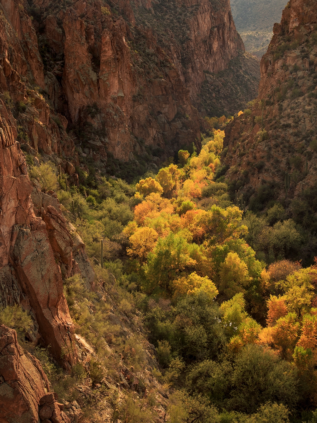 Flanked by saguaros, cottonwoods glow in late-afternoon light along Pinal Creek a few miles upstream from the creek’s mouth at the Salt River. This location is in the Salt River Canyon Wilderness, which has no established trails; however, a drive to the edge of the wilderness area on State Route 288 offers leaf-peeping opportunities along the river in late fall. | Photograph by Joel Hazelton
SALT RIVER CANYON
PEAK COLOR: Late November to mid-December
Directions: From Globe, go west on U.S. Route 60 for 3 miles to State Route 188. Turn right onto SR 188 and continue 14.7 miles to State Route 288. Turn right onto SR 288 and continue 4.5 miles to the bridge across the Salt River. Park in the dirt lot on the north side of the river. The entire route is paved.
Information: Globe Ranger District, 928-402-6200 or fs.usda.gov/tonto
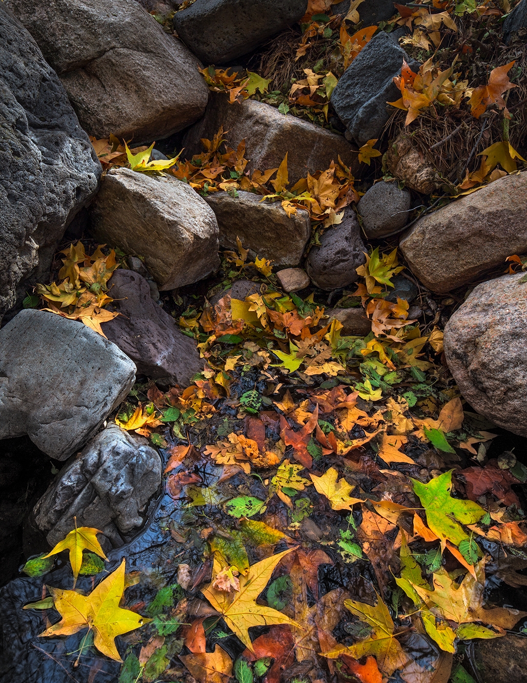 Fallen sycamore leaves form a kaleidoscope of color in a small pool along the creek. The Nelson Trail, part of a network of trails in the Pine Mountain Wilderness, crosses Sycamore Creek several times as it winds through a shaded riparian area. | Photograph by Joel Hazelton
SYCAMORE CREEK
PEAK COLOR: October
Directions: From Black Canyon City, go north
on Interstate 17 for 24 miles to Dugas Road (Exit 268). Turn right onto Dugas Road (Forest Road 68) and continue 18 miles to the Salt Flat Trailhead, where the Nelson Trail begins. A high-clearance vehicle, such as an SUV or truck, is required.
Information: Verde Ranger District, 928-567-4121 or fs.usda.gov/prescott
To see more fall color in Arizona, subscribe to our digital edition for access to the October issue of Arizona Highways.