
Tonto National Forest, Superstition Mountains
What are you going to remember about 2020? Actually, don’t answer that; this is a family magazine. But despite that year’s challenges, maybe we’ll also remember it as a year when we made the best of it. Which, it turns out, you can do on the Apache Trail, one of Arizona’s most beloved roads. While damage from a 2019 landslide still blocks part of the route, the Arizona Department of Transportation this year repaired the Apache Trail up to Fish Creek Vista, turning an already scenic road into a day trip with a panoramic payoff.
From Apache Junction, east of Phoenix, head northeast on the Apache Trail (State Route 88), which rolls past mature saguaros, chollas and the dramatic cliffs of the Superstition Mountains on the right. Within a few miles, you’ll come to three sites where you easily could spend all day: the Superstition Mountain Museum, whose centerpiece is a chapel built for a 1969 Elvis Presley film; Goldfield Ghost Town, an old mining town reborn as a tourist attraction; and Lost Dutchman State Park, which provides access to some of the Superstitions’ best hiking routes. But those destinations can wait for another day.
A few miles later, dramatic rock formations rise on the left side of the road, punctuating a view of the distant Four Peaks. At this point, any passengers who are prone to carsickness may want to close their eyes, because the road begins a series of hairpin turns as it climbs into the foothills of the Superstitions. Those who keep their eyes open will see giant saguaros on both sides of the road, which crests a hill around Mile 9 and begins its descent toward Canyon Lake — one of several reservoirs on the Salt River. You’ll skirt the lake’s southern shore, crossing two one-lane bridges along the way, before continuing east.
The next stop, at Mile 16.5, is Tortilla Flat, a tiny “town” that boasts a population of 6, a lively restaurant and an ice cream shop whose specialty is prickly pear gelato. You’ll see plenty of prickly pears over the next few miles, along with big agaves and even bigger views of distant mesas and rolling hills. The pavement ends around Mile 22, and what’s left is a wide, relatively smooth dirt road that’s suitable for passenger cars. Just beyond the Tortilla Trailhead, the road passes a dramatic canyon on the left. A half-mile later, it reaches Fish Creek Vista, where there are restrooms and a paved interpretive trail.
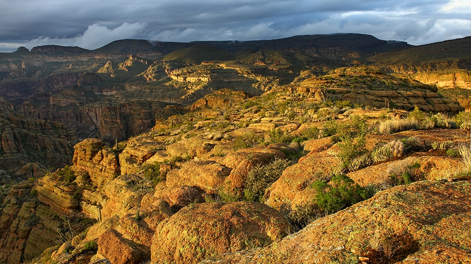
From the parking area, follow the paved trail less than a quarter-mile to its end, where you’ll be treated to a view worthy of the drive: a steep, foreboding canyon with rocky cliffs on its sides and saguaros at its bottom. The trail also offers a look at the section of the Apache Trail that’s currently off-limits. At press time, there’s no timetable for fully reopening the route, as its remoteness and steep grades make repairs difficult. When it’s whole, SR 88 runs all the way to Theodore Roosevelt Lake, the largest lake located entirely in Arizona.
Enjoy your time at the vista, and be sure to take a few minutes to enjoy how quiet it is in this uninhabited part of the state. Although you can’t go on, rest assured that the views on the way back are just as good. And so is the prickly pear gelato.
Note: Mileages are approximate.
Length: 23.6 miles one way
Directions: From the intersection of Main Street and the Apache Trail (State Route 88) in Apache Junction, go northeast, then east on the Apache Trail for 23.6 miles to Fish Creek Vista.
Vehicle requirements: None in good weather.
Warning: Back-road travel can be hazardous, so be aware of weather and road conditions. Carry plenty of water. Don’t travel alone, and let someone know where you are going and when you plan to return.
Information: Mesa Ranger District, 480-610-3300 or fs.usda.gov/tonto