A TRIP TO SKELETON CAVE
A Trip to Skeleton Cave Daniel Joseph Bangs Donald Bangs
A trip to the scene of one of the Southwest's bloodiest massacres is yours for the taking, but don't attempt it unless you have already had a well rounded diet of desert hiking and climbing. The area which lies just north of the Superstition Mountains is some of the ruggedest to be found in the state of Arizona; but is also some of the most interesting and scenic. If you are physically fit for it and have the proper equipment, it is an enjoyable trip well worth your taking, and one you will long remember.
The Story of the Battle of the Caves takes place well over three quarters of a century ago. In the year 1872, as a result of an Apache chief's attempt to assassinate him during a peace pow wow, General George Crook received immediate directions from the War Department to "Drive the Indians back onto their reservations and to use the army in securing peace within Arizona." For over a year General Crook, commander of the troops in Arizona, had been attempting peaceful means in pacifying the Apaches, who had been conducting numerous raids on the travelers and settlers of this state. But now he had his orders.
The snow and cold weather had already set into the high mountain regions, confining the Apaches to the lower and more accessible areas when, on November 15, he initiated his historic Campaign Against the Apaches of 1872-'73. At the height of the campaign, on December 27, Captain James Burns and several troops of the Fifth Cavalry were enroute from Fort McDowell to the Salt River where a group of Mojave Apaches were reportedly in hiding in a great cavern fortress, somewhere on the south slope of the Four Peaks range of mountains, several miles north of the Superstitions. While crossing through the rugged Four Peaks Pass, Capt. Burns made a surprise attack on a small Apache village, and succeeded in killing six, while the rest fled through the canyons, in the direction of the Salt River. Burns did, however, capture the seven year old son of the chief, and later had him christened Mike Burns, and raised and educated him as a white man. It was Mike's father who died less than thirty hours later along with over one hundred of his tribesmen.
That evening Capt. Burns camped his men at the mouth of the Cottonwood Creek on the Salt River, and started making plans for the search and siege of the hidden fortress hideout. Accompanying them were one hundred and thirty Pima and Maricopa Indians acting as scouts and guides for the soldiers. One of these, a Pima by the name of Natanje, told the officers that at one time he had lived in the cave that was now being used by the Apaches, and that he could guide the troops to it. Since Burns had received word of another band of Apaches in the area, he dispatched fifty-two of the troopers to the cave, while he took the remainder of the soldiers with him in search of this other band of Indians.
Lieutenant Ross commanded an advance party of twelve men, while Lt. John G. Bourke followed at some distance with the remaining forty. The expedition was under way by eight o'clock that evening, traveling under the cover of nightfall. As they approached the site of the cave, Ross sighted a small band of Apaches dancing around a campfire on a small level area of the slope rock, leading from the base of the cliff down to the river. When the soldiers opened up with a volley of shots, the Indians made a hasty retreat up to the cave, leaving about a half dozen dead behind them. Lt. Bourke arrived shortly afterwards, and the men took position behind rocks and boulders commanding the cave. The twelve men of the advance party stood by in reserve, some distance further on down the slope. As it later turned out, this "great cavern fortress" was actually no more than an elliptical undercut, about sixty-five feet long and twenty-five feet deep with an inward sloping granite slab ceiling, at the base of a one hundred and seventy foot cliff. In front of the cave and at a lower level there was a small basin, bordered on the
front by a wall of boulders that had fallen from the rim rock above. From this wall the Apache braves carried on the battle, while the women and children remained in the 'safety' of the back of the cave. Throughout the night there was an intermittent exchanging of fire-power. At one time an Apache apparently sent to get help, made his way up to the rim rock, and then couldn't resist giving out a war whoop. This fatal mistake immediately brought an accurate shot from the rifle of Trooper Cahill, below. At another time during the night, one of the Indians sneaked through the line of soldiers, mounted a boulder behind them, and began chanting Apache war songs. What he wasn't counting On, however, was the twelve reserve soldiers behind him. Shortly before daybreak, in the early morning light, the two officers were able to make out the sloping ceiling of the cave, which gave them the idea that was to be the beginning of the end for the Indians. As soon as it was light enough for all of the soldiers to clearly see the sloping ceiling, which was the only part of the cave visible, due to the wall of boulders in front of it, they opened fire, aiming their shots at the ceiling, thus ricocheting the bullets in a volley of hail upon the inhabitants within. This maneuver inflicted a great many deaths and wounds upon the ranks of the Apaches. When a 'cease fire' was finally called, the chief still refused to surrender, stating that he and his men would fight until death. Death came very shortly.
Just after daybreak, Capt. Burns and his men returned from their mission, to a point on the rim rock directly above the cave. They then commenced to roll boulders over the side of the cliff. Later in his report of the battle, Lt. Bourke described the incident as follows: “The destruction was sickening; the air was filled with bounding, plunging fragments of stone; no human voice could be heard in such a cyclone of wrath; the volume of dust was so dense that no eye could pierce it.” At any rate, this terminated the Battle of the Caves.
Seventy-six men, women, and children were killed outright in the massacre. Another eighteen were mortally wounded, and left to die, while about thirty-five wounded braves were taken prisoner.
The Pimas and Maricopas helped themselves to the provisions, weapons, and ammunition found in the cave; and that which they did not take was stacked and burned, so that it couldn't be reclaimed later by other Apaches.
The savagery of the Apaches had long been endured by the peace loving Pima and Maricopa Indians, and the army officers knew this. Not being particularly delighted with the task of caring for thirty-five wounded prisoners, the soldiers turned them over to the care of their Indian guides for the return journey to Fort McDowell, near Phoenix. What actually happened to the prisoners at the hands of their guards has been best left unsaid in the army records, but not one of them ever reached the fort.
About forty years later a rancher by the name of Jack Adams led a group of friends in search of the cave. They found it strewn with the skeleton remains of the fallen Indians, thus deriving its present day popular name of “Skeleton” or “Skull Cave.” They had a photographer with them, and a picture was taken showing the men with some of the skulls and bones lined up along a ledge within the cave. When the story of the cave was made public, the Apaches had the remains of their tribesmen removed to an Apache burial ground.
The cave is much more accessible now than it was for the cavalry men of 1872, since the back waters of the Mormon Flat Dam, on the Salt River, allow a boat to land at a point below the cave, from where the actual hike begins.
The amount of equipment necessary is minimal, but very essential. As for clothing, any comfortable outdoor clothing with full length pants will do. Since the sun gets pretty hot there, it is best to have a long sleeved shirt, and also a hat. A well-fitted pair of high top leather hiking boots is an absolute must. A filled water bag and canteen for each member of the party are essential, and since it is an eight to ten hour round trip, sack lunches should also be included. Along with a compass, the map and directions included in this article will insure your reaching the actual cave where the battle took place, without wasting time and energy in hiking up to any of the many other caves visible along the canyon wall. Boats are available for rent at the Canyon Lake Resort, or if you have your own boat, there are good launching sites near the resort area.
The Canyon Lake Resort is 45 miles from Phoenix. Travel east on U.S. Highway 60 through Tempe and Mesa until you reach Apache Junction, about 30 miles east of Phoenix. From here you take the road forking to the left and travel northeast on State Highway 88, which is well marked at the junction as The Apache Trail. It is a paved road all the way to the resort, which is just to the left after you cross the second steel bridge, about 15 miles from Apache Junction. Boat launching sites are a little further on up the road.
Boats with outboard motors ranging from 3 hp to 25 hp are available for reasonable hourly or daily rates.
The Superstitions...now placid... once a battle ground
But, since speed is not generally the essence in a scenic trip such as this, we found the 3 hp outboard more economical and suitable to our use. The rental on it is $1.25 per hr., or $7.50 for ten hours. A $10.00 deposit is required. We took it for the ten hour period, getting underway at seven in the morning.
As you leave the boat landing at the mouth of La Barge Creek, you take a northwesterly heading of 310 deg. for about fifteen minutes until the main channel which you take to the right, comes into view. The Mormon Flat Dam is visible on your left. The seven mile trip up the main channel takes just about an hour and a half with the 3 hp motor. Keep track of the various numbered landmarks outlined on the map, so that you will know where you are, and when to start looking for your landing site.
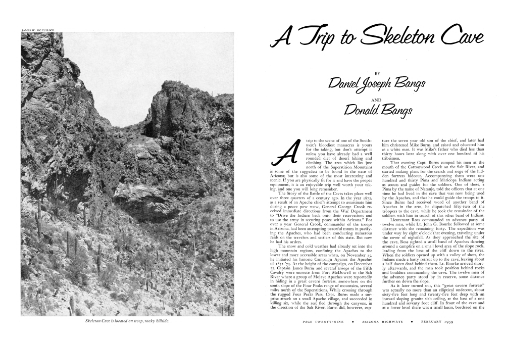
The Skeleton Cave is situated at the base of the cliff on the north wall of the canyon, right at the vertex of a sharp angle in the canyon's path. It is not visible from below, but its location can be ascertained by a vertical uprise in the rim rock at a point directly above the cave.
After you have landed your boat, the hike up to the cave will take from an hour to an hour and a half, and will take you to a point 1,200 feet above the water. It is a steep and rugged climb, so take plenty of time to avoid any mishaps.
There are several small canyon openings along the shoreline here. The largest and most predominant of these is the one you take. After climbing the first ledge at the mouth of the canyon, the rest is relatively easy climbing over rocks and boulders and through brush, until you reach a dead end, with a sheer vertical wall in front of you. The wall on your right is rough enough, and solid enough, to allow one person at a time to climb the remaining thirty feet to the surface of the slope rock. Make special note of this canyon you have just come up, so that you won't confuse it with any of the many other similar looking canyons in the area, on your trip back down. From here, your best bet is to start heading up towards the cliffs and to the right. After going for some distance over some fairly steep and crumbly decomposed granite and lava formations, you will see an elongated cave on the face of the cliff to your left. This is not the cave you are headed for, but it is linked to the Skeleton Cave by by the remains of an old Indian trail running along the base of the cliff. You can reach this trail by hiking up to it at a point about two hundred feet to the right of the cave. Following this trail, to the right, along the base of the cliff will bring you to the Skeleton Cave within a few minutes.
The front of the cave is shielded by a dense growth of brush, but it is approachable at either end. Within the cave you can still see some of the bullet scars in the ceiling, and over on the left end is the ledge on which the skulls were lined up in the picture taken when Jack Adams visited the cave. About a foot of dirt has accumulated on the floor of the cave since the massacre; and quite a few relics have been dug and sifted from it in recent years. The sloping ceiling at the back of the cave is heavily blackened by the fires over which the Indians did their cooking. It is indeed, an unusual experience to stand at the scene of such a bloody ordeal and almost be able to hear the fading echoes of the rifles and plunging boulders as they brought death and destruction to so many.
One major point of advice can be taken from Gen. Crook's decision to wait until winter to initiate his campaign. To the average person, not thoroughly used to it, the summer heat on those sloping canyon sides can be the next thing to unbearable. Your trip to Skeleton Cave will be much more enjoyable during the winter and spring months.
Already a member? Login ».