Scenic Hikes in Prescott Country
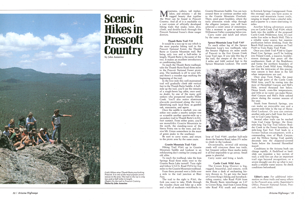
(Left) Hikers atop Thumb Butte, overlooking Prescott. It is one of the most popular prominences in the area. The trail to the top is only two-and-a-half miles in length. (Right) On the trail in Prescott Country. Photos by John Annerino Mountains, valleys, tall timber, lakes, and streams all the rugged beauty that typifies the West can be found in Prescott Country. And all of it is reachable via a vast system of officially developed hiking trails that snake, twist, dive, climb, and double-back through the Prescott National Forest's three ranger districts.
Thumb Butte Trail #33
It would be a toss-up to say which is the most popular hiking trail in the Prescott National Forest, the Thumb Butte or Granite Mountain trail. But being only two and a half-miles in length, Thumb Butte is the easier of the two. It makes an excellent introductory or conditioning hike.
To reach the Thumb Butte trailhead, take the Thumb Butte Road three miles to the Prescott National Forest picnic area. The landmark is off to your left, and there's a wooden sign marking the beginning of the trail.
In the first mile this well-maintained trail will gradually climb 600 vertical feet to the Thumb Butte Saddle. A half-mile up the trail, you'll see the remains of a rough-hewn log cabin, once used, no doubt, by one of the many gold seekers who prospected nearby Miller Creek. You'll also notice aluminum placards positioned along the trail, identifying such local flora as gambel oak, manzanita, and agave.
Once the saddle is reached, you can either rest under a nearby juniper tree or scramble another quarter-mile up a secondary trail to Thumb Butte's 6,522-foot summit. From either point, you'll see monolithic Granite Mountain to the north, the standing-wave of the Sierra Prieta rim to the west, and elusive Mt. Union somewhere in the maze of green peaks to the southeast.
Be sure to carry water, and return to the picnic area by the same route.
Granite Mountain Trail #261
Hiking Trail #261 up to Granite Mountain Saddle and Lookout is an exhilarating day's outing for young and old alike.
To reach the trailhead, take the Iron Springs Road three miles west to the Granite Basin Lake turnoff. Turn right and follow U.S.F.S. Road #374 for five miles to the Granite Mountain trailhead.
From there proceed west a little over a mile to the trail junction at Blair Pass.
The trail to the right is #261, the fork you want to take. Walk through the wooden chute and hike up a mile and a half of moderate switchbacks to Granite Mountain Saddle. You can turn around there or continue another mile to the Granite Mountain Overlook. There, amid giant boulders, where the early afternoon winds whip through the alligator junipers, you will have achieved a sweet sense of remoteness. Take a moment to gaze at sprawling Williamson Valley sweeping below you.
Carry water and lunch and return by the same route.
Spruce Mountain Loop Trail #307
To reach either leg of the Spruce Mountain Loop's two trailheads, take the Senator Highway six miles south of Prescott to the first Groom Creek Loop Trail sign. If you take this leg of the trail, the steeper of the two, it's 3 miles and 1400 vertical feet to the Spruce Mountain Lookout. The south loop of Trail #307, another half-mile down the Senator Road, takes 51/2 miles to climb to the Lookout.
Occasionally, several old mining roads will crisscross these two trails, but frequent yellow blaze marks make it all but impossible to go astray. Small game is plentiful.
Carry water and bring a lunch.
Castle Creek Wild Area
The Crown King District is big, rugged, beautiful, and remote, with more than a dash of enchanting his-tory thrown in. To get into the heart of Crown King's hiking and horseback-riding country, take Road #259 from the Bloody Basin interchange on I-17 to Crown King. And from Crown King take Road #52 south and southeast to Kentuck Springs Campground. From this strategic spot, you have access to canyon and mountain forest trails, ranging in length from a playful mile-and-a-quarter to a more enervating 11 miles.
Another hiking adventure awaits you on Castle Creek Trail #239, which leads into the middle of the proposed Castle Creek Wilderness Area. It's just under five miles to Beach Well. This is a reliable water source, but requires purification before drinking. From the Bench Well junction, continue on Trail #239 to Twin Peaks Trail #240.
Once you climb Trail #240 to Upper Dead Cow Springs, you'll be looking into Poland Creek, a massive, boulder-strewn drainage that pours off the southeastern flank of the Bradshaws and forms the northern boundary of the Castle Creek Wild Area. Walking out into the intricacies of this precipitous canyon is best done in the fall when temperatures are cool.
Once atop Twin Peaks, the inner basin high point of the Castle Creek Wild Area, you'll be staring into the maw of Horsethief Canyon and Hell's Hole, several thousand feet below. Dense brush, oven-like temperatures, and little or no water can make Horse-thief Canyon and Hell's Hole unkind places during the warmer seasons of the year.
South from Kentuck Springs, you can make an enjoyable one and a quarter-mile hike to the top of Horse-thief Lookout. Or you can contour another mile and a half from the Look-out to Coal Camp Spring.
Several other trails can be reached from Coal Camp Springs: the three-mile-long Tip-Top Trail follows Boulder Creek to the Forest boundary; the mile-long East Fort Trail leads to a former Indian encampment, with a commanding view of Black Canyon; and the Willow Spring Trail quickly descends into the chaparral-covered basin below the forested Horsethief massif.
Conditions in the Arizona bush can change rapidly. A flashflood or landslide can inundate a key section of trail; a wild fire can char an important trail sign beyond recognition; or a severe drought can dry up what is normally a reliable water source. So check conditions beforehand.
Already a member? Login ».