Casa Grande, An Ancient Astronomical Observatory
The Casa Grande ruin has fascinated visitors since Padre Kino, the Jesuit missionary, first saw it in 1694. It is an unusually well-built structure, the center portion of the building rising three stories above a platform mound. The thick adobe walls of the structure have openings in them, some of which were obviously intended as doors or devices to provide ventilation, while others appear to be deliberately made but do not seem to have served a practical purpose. Frank Pinkley, a National Park Service archeologist and administrator, suggested in 1918 that some of the openings in the walls may have been used as viewing ports for astronomic observations. Pinkley's suggestion was supported by the fact that the Indian name of the building in the present Pima language translates into "the home of the cruel and bitter man who looked through holes in his house to salute the sun."
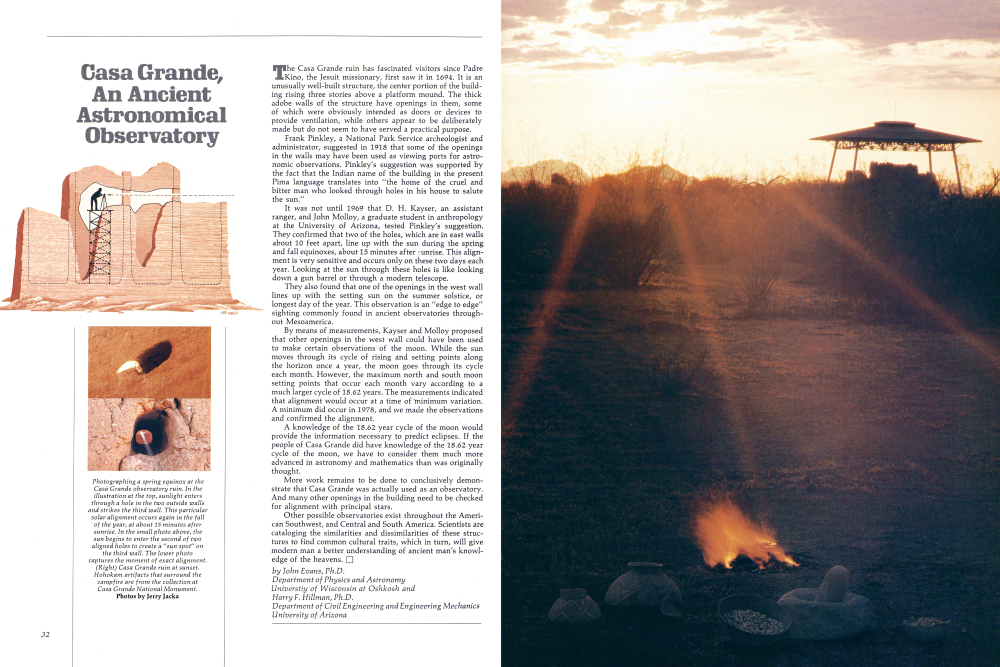
It was not until 1969 that D. H. Kayser, an assistant ranger, and John Molloy, a graduate student in anthropology at the University of Arizona, tested Pinkley's suggestion. They confirmed that two of the holes, which are in east walls about 10 feet apart, line up with the sun during the spring and fall equinoxes, about 15 minutes after sunrise. This alignment is very sensitive and occurs only on these two days each year. Looking at the sun through these holes is like looking down a gun barrel or through a modern telescope. They also found that one of the openings in the west wall lines up with the setting sun on the summer solstice, or longest day of the year. This observation is an "edge to edge" sighting commonly found in ancient observatories throughout Mesoamerica.
By means of measurements, Kayser and Molloy proposed that other openings in the west wall could have been used to make certain observations of the moon. While the sun moves through its cycle of rising and setting points along the horizon once a year, the moon goes through its cycle each month. However, the maximum north and south moon setting points that occur each month vary according to a much larger cycle of 18.62 years. The measurements indicated that alignment would occur at a time of minimum variation. A minimum did occur in 1978, and we made the observations and confirmed the alignment. A knowledge of the 18.62 year cycle of the moon would provide the information necessary to predict eclipses. If the people of Casa Grande did have knowledge of the 18.62 year cycle of the moon, we have to consider them much more advanced in astronomy and mathematics than was originally thought.
More work remains to be done to conclusively demonstrate that Casa Grande was actually used as an observatory. And many other openings in the building need to be checked for alignment with principal stars.
Other possible observatories exist throughout the American Southwest, and Central and South America. Scientists are cataloging the similarities and dissimilarities of these structures to find common cultural traits, which in turn, will give modern man a better understanding of ancient man's knowledge of the heavens.
by John Evans, Ph.D. Department of Physics and Astronomy Universtiy of Wisconsin at Oshkosh and Harry F. Hillman, Ph.D. Department of Civil Engineering and Engineering Mechanics University of Arizona
Ruins from page 27
And are nestled into a quiet forested area loved by hikers and campers who use the vast adjoining Gila Wilderness area.
Nobody has to stand in line to see these ruins, but the view would be worth waiting for anyway.
Casa Grande National Monument, Arizona Water is the name of the game . . . if the game is desert survival. The Hohokam played the game better than any other aboriginal North Americans. They wrote the rule book.
Their extensive irrigation canals several hundred miles of them in the Gila and Salt river valleys alone were begun 18 centuries before Columbus discovered America. By diverting water from living streams to crop fields far from the source, they accomplished another feat: they had freedom of choice about where to put their villages.
With water management came assured food supplies and another emancipation: leisure time enough to develop arts and crafts. In weaving, such things as tapestry, twill, gauze, and weft-warp openwork (lace) provided means for decorating cloth. Effigies were carved from stone or formed with pottery clay. Personal adornments were made of shells imported from the Gulf of California. But their crowning achievement was the development of a technique for etching designs on shells, using pitch as the acid-resistant material and saguaro cactus fruit juice as the etching agent. It was a method they had perfected by 1100, 500 years before European craftsmen used the same principle to decorate metal armor.
to develop arts and crafts. In weaving, such things as tapestry, twill, gauze, and weft-warp openwork (lace) provided means for decorating cloth. Effigies were carved from stone or formed with pottery clay. Personal adornments were made of shells imported from the Gulf of California. But their crowning achievement was the development of a technique for etching designs on shells, using pitch as the acid-resistant material and saguaro cactus fruit juice as the etching agent. It was a method they had perfected by 1100, 500 years before European craftsmen used the same principle to decorate metal armor.
This is all according to Dr. Emil Haury, former head of the Department of Anthropology, University of Arizona, and excavator of Snaketown, the “capital city” of the Hohokam, a domain of 50,000 square miles that stretched from Arizona's desert border with Mexico, over 200 miles north to the mountainous region near Flagstaff.
Snaketown has been covered again with desert soil to protect it from weather and vandals and to preserve it for future generations of archeologists.
Other Hohokam cities, made of sticks and mud on open ground, have long since been reclaimed by the desert.
Though the society grew and flourished, especially from A.D. 1000 to 1400, the Hohokam dramatically and inexplicably "vanished" in the early decades of the 1400s. One theory advanced to explain the disappearance is that by the time the Spaniards arrived, the Hohokam had become Pima and Papago Indian cultures. If true, that speculation only poses another question: Why did the influential culture lapse into decline?
The Hohokam (a Piman word meaning those who "have been all used up") left behind one remarkable edifice totally different from anything else in their culture, they erected Casa Grande, a pueblo-style structure that may have been introduced by the Anasazi by way of the Sinagua or Salado people.
In any event, the three-story Casa Grande (Great House) represents yet another prehistoric, labor-intensive building project. Yet another mysterious marvel that may have functioned as an astronomical observatory.
At Casa Grande, you can see everything ruins, the museum's art and artifacts, maps of the canal systems, and the small botanical garden - in less than an hour.
But as an update on desert survival, water management, and cultural priorities, it's an hour filled with things both timely and timeless. onto National Monument, Arizona Like the Sinaguans, the Salado Indians developed a culture that blended Anasazi, Mogollon, and Hohokam traits. And the Saladoans themselves acted as cultural conduits for the three dominant cultures. This peaceful inter-mingling continued until early in the 1400s when they probably were absorbed by the other groups.
Though one waggish anthropologist has suggested that the Salado culture is the figment of other anthropologists' imaginations, Gila polychrome pottery indicates the Saladoans were distinct and different from other groups.
Evidence is sketchy because most Salado sites were located in the Tonto Basin area that was inundated in 1911 with the completion of Roosevelt Dam and the formation of Roosevelt Lake.
The two remaining sites are Besh Ba Gowah ruins, now showing the ravages of neglect, disinterest, and budgetary priorities, and the upper and lower ruins at Tonto.
The Tonto ruins in cliff crevices as well as dry storage caves nearby have yielded well-preserved lace-like cotton textiles, other weavings of yucca fiber and hair; sandals, baskets, and mats plaited of yucca leaf; tools such as tat-too needles; spinning and weaving equipment; bows and arrows; and Gila polychrome pottery, of course.
The exhibits in the visitors center can be seen in less than two hours.
An additional attraction to visiting Tonto is the scenic drive over the Apache Trail which was created as a supply road during the building of Roosevelt Dam. It's only partly paved and has a series of sharp hairpin curves and zigzagging ascents and descents. It's slow going (25 miles an hour, tops) and shouldn't be attempted in wet weather. But, for desert and mountain scenic spectaculars, there's nothing like it. There also is a modern fully paved road to the site, via Globe, Arizona.
Walnut Canyon National Monument, Wupatki National Monument, Tuzigoot National Monument, and Montezuma Castle and Well National Monument, Arizona These are the ruins of the Sinagua (Spanish for “without water”) whose saga has been told elsewhere in this issue. Their melting pot communities, like those of the Salado, included immigrants from the Anasazi, Mogollon, and Hohokam groups and were centers for the adaption, modification, and exchange of ideas and technology. As sight-seeing spots, each is remarkably different from the others, and each is within easy reach of Flagstaff. As a suggestion, if you have three days to spend, visit Walnut Canyon one day; Wupatki and Sunset Crater (the volcano that is responsible for the Sinagua saga in its beginning) another day; Tuzigoot and Montezuma Castle and Well on the third day, with a loop route to Oak Creek Canyon as an extra added attraction. If I had only one day, I'd opt for Wupatki-Sunset Crater, but the popular spot (a half-million visitors a year) is Montezuma Castle.
(Left) Nine miles northeast of Montezuma Castle is “bottomless” Montezuma Well, a limestone sink with small dwellings on its lip And, at its base, prehistoric travertine-encrusted irrigation ditches.
(Right) Beneath the beautifully preserved walls of Montezuma Castle, a Hopi Indian family replays an ancient journey for the photographer. As their predecessors once did, the hunter carries a rabbit stick which can be thrown to kill small game.
(Bottom) A handwoven Sinagua bag found at Montezuma Castle, now on display at the visitors center. Photos by Jerry Jacka (don't deserve to be shunted aside), going into Walnut Canyon is like going into the canyon primeval, a quiet chasm removed from the outside world, and an environmental delight to photographers, geologists, naturalists, and hikers.
Tuzigoot has one of the best artifacts displays in the Southwest, including prehistoric jewelry, religious objects, tools, textiles, and a reconstructed pueblo room.
Montezuma Castle no longer can be entered by visitors because of the instability of its walls, but, even from the visitors center below, it looks like a place Montezuma would have lived in had he come north. The Well, a couple of miles from the castle, is a natural lake-like limestone sink fed by a spring, and it sometimes seems more like a bird sanctuary than a prehistoric watering hole. Remember the admonishment in those little guidebooks you pick up at the visitors centers: Take only photographs, leave only foot-prints.
Already a member? Login ».