
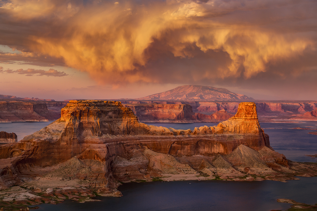
Glen Canyon National Recreation Area
Year Designated: 1972
Area: 1.25 million acres (Arizona and Utah)
Wilderness Acreage: None; however, 588,855 acres have been proposed as the Glen Canyon Wilderness and are managed as a wilderness area.
When to Visit: Year-round
Directions (to Carl Hayden Visitor Center at Glen Canyon Dam): From Page, go north on U.S. Route 89 for 2.5 miles to the Carl Hayden Visitor Center, on the right.
Directions (to Lees Ferry): From Page, go south on U.S. Route 89 for 23 miles to U.S. Route 89A. Turn right onto U.S. 89A and continue
14.5 miles to Lees Ferry Road, just past the Navajo Bridge Interpretive Center. Turn right onto Lees Ferry Road and continue approximately 4.5 miles to Lees Ferry.
Entrance Fees: $30 per private vehicle, $15 per cyclist or pedestrian
Lodging: Yes, at Lake Powell Resort; 800-528-6154, lakepowell.com
Camping: Yes, at developed and primitive sites; nps.gov/glca/planyourvisit/camping.htm
Dogs Allowed: Yes (on a leash), but only in certain areas; visit nps.gov/glca/planyourvisit/pets.htm for details.
Scenic Drives: Yes
Wildlife Viewing: Yes
Telephone: 928-608-6200
Website: nps.gov/glca
Casa Grande Ruins National Monument
Year Designated: 1892 (prehistoric and cultural reserve), 1918 (national monument)
Area: 473 acres
Wilderness Acreage: None
When to Visit: October through March
Directions: From Phoenix, go southeast on Interstate 10 for 36 miles to State Route 387. Turn left (east) onto SR 387 and continue 7.5 miles to State Route 87. Turn right onto SR 87 and continue 7 miles to Arizona Boulevard. Turn right onto Arizona Boulevard and continue 0.5 miles to the monument entrance, on the right.
Entrance Fees: None
Lodging: No
Camping: No
Dogs Allowed: Yes (on a leash)
Scenic Drives: No
Wildlife Viewing: Yes
Telephone: 520-723-3172
Website: nps.gov/cagr
Canyon de Chelly National Monument
Note: At press time, this site was closed due to COVID-19 restrictions.
Year Designated: 1931
Area: 83,840 acres
Wilderness Acreage: None
When to Visit: Spring through fall
Directions: From Holbrook, go east on Interstate 40 for 46 miles to U.S. Route 191 (Exit 333). Turn left (north) onto U.S. 191 and continue 74 miles to Indian Route 7. Turn right onto IR 7 and continue 2.7 miles to the monument visitors center.
Entrance Fees: None for overlooks or White House Trail; backcountry hikes and horseback rides require hiring a Navajo guide.
Lodging: Yes, at Thunderbird Lodge; 928-674-5842, thunderbirdlodge.com
Camping: Yes, at Cottonwood Campground; 928-674-2106
Dogs Allowed: Yes (on a leash), but only at overlooks, campground and parking lots
Scenic Drives: Yes
Wildlife Viewing: Yes
Telephone: 928-674-5500
Website: nps.gov/cach
Chiricahua National Monument
Year Designated: 1924
Area: 12,025 acres
Wilderness Acreage: 10,462 acres
When to Visit: Spring and fall
Directions: From Willcox, go east on State Route 186 for 31 miles to State Route 181. Turn left (east) onto SR 181 and continue 4 miles to the monument entrance.
Entrance Fees: None
Lodging: No
Camping: Yes, at Bonita Canyon Campground; 877-444-6777
Dogs Allowed: Yes (on a leash), but only where cars may go
Scenic Drives: Yes
Wildlife Viewing: Yes
Telephone: 520-824-3560
Website: nps.gov/chir
Coronado National Memorial
Year Designated: 1941 (international memorial), 1952 (national memorial)
Area: 4,830 acres
Wilderness Acreage: None
When to Visit: Fall through spring
Directions: From Sierra Vista, go south on State Route 92 for 13.5 miles to Coronado Memorial Road. Turn right (south) onto Coronado Memorial Road, which turns into Montezuma Canyon Road, and continue 5 miles to the memorial entrance.
Entrance Fees: None
Lodging: No
Camping: No
Dogs Allowed: Yes (on a leash), but only where cars may go and on the Crest Trail
Scenic Drives: Yes
Wildlife Viewing: Yes
Telephone: 520-366-5515
Website: nps.gov/coro
Fort Bowie National Historic Site
Year Designated: 1960 (national historic landmark), 1972 (national historic site)
Area: 999 acres
Wilderness Acreage: None
When to Visit: Spring and fall
Directions: From Willcox, go east on Interstate 10 for 23 miles to Bowie (Exit 362). Continue onto the I-10 business route and go 2 miles to Apache Pass Road. Turn right (south) onto Apache Pass Road and continue 13 miles (the last mile is unpaved) to the Fort Bowie Trailhead. From there, it’s a moderate 3-mile (round-trip) hike to the site.
Entrance Fees: None
Lodging: No
Camping: No
Dogs Allowed: Yes (on a leash)
Scenic Drives: No
Wildlife Viewing: Yes
Telephone: 520-847-2500
Website: nps.gov/fobo
Grand Canyon National Park
Year Designated: 1893 (forest reserve), 1908 (national monument), 1919 (national park)
Area: 1.22 million acres
Wilderness Acreage: None
When to Visit: Year-round
Directions (South Rim): From Flagstaff, go northwest on U.S. Route 180 for 49 miles to State Route 64. Turn right (north) onto SR 64 and continue 24 miles to the park entrance station.
Directions (North Rim): From Flagstaff, go north on U.S. Route 89 for 110 miles to U.S. Route 89A. Turn left onto U.S. 89A and continue 55 miles to State Route 67 (North Rim Parkway). Turn left onto SR 67 and continue 31 miles to the park entrance station.
Entrance Fees: $35 per private vehicle, $20 per cyclist or pedestrian
Lodging: Yes, at several lodges; 888-297-2757, grandcanyonlodges.com/lodging
Camping: Yes, at three campgrounds; 877-444-6777, recreation.gov
Dogs Allowed: Yes (on a leash)
Scenic Drives: Yes
Wildlife Viewing: Yes
Telephone: 928-638-7888
Website: nps.gov/grca
Grand Canyon-Parashant National Monument
Year Designated: 2000
Area: 1.05 million acres
Wilderness Acreage: 147,460 acres
When to Visit: Spring and fall
Directions: Before you attempt to visit this remote monument, go to the Public Lands Information Center (345 E. Riverside Drive) in St. George, Utah, to obtain a map and learn about weather forecasts and road conditions. From there, go east on Riverside Drive for 1.3 miles, turn right (south) onto River Road and continue 6.7 miles to the Arizona-Utah state line. From there, Bureau of Land Management Road 1069 leads south to several monument access points. For other routes, consult the staff at the information center. The BLM recommends you use a high-clearance vehicle and take plenty of water, food, extra gasoline and at least two spare tires.
Entrance Fees: None
Lodging: No
Camping: Yes, in the backcountry; 435-688-3200
Dogs Allowed: Yes (on a leash), but only in the Park Service portion of the monument
Scenic Drives: Yes
Wildlife Viewing: Yes
Telephone: 435-688-3200 (Public Lands Information Center in St. George, Utah)
Website: nps.gov/para
Hubbell Trading Post National Historic Site
Note: At press time, this site was closed due to COVID-19 restrictions.
Year Designated: 1965
Area: 160 acres
Wilderness Acreage: None
When to Visit: Year-round
Directions: From Flagstaff, go east on Interstate 40 for 134 miles to U.S. Route 191. Turn left (north) onto U.S. 191 and continue 38 miles to State Route 264. Turn left onto SR 264 and continue 0.5 miles to the site entrance, on the left.
Entrance Fees: None
Lodging: No
Camping: No
Dogs Allowed: Yes (on a leash), but only in parking lot
Scenic Drives: No
Wildlife Viewing: No
Telephone: 928-755-3475 (visitors center), 928-755-3254 (trading post)
Website: nps.gov/hutr
Lake Mead National Recreation Area
Year Designated: 196
Area: 1.5 million acres (Arizona and Nevada)
Wilderness Acreage: 185,000 acres
When to Visit: Year-round
Directions: From Kingman, go northwest on U.S. Route 93 for 75 miles (you’ll cross into Nevada) to the recreation area’s visitors center. Entrance stations are located here and at other locations around the lake.
Entrance Fees: $25 per private vehicle, $15 per cyclist or pedestrian
Lodging: Yes, at three resorts; nps.gov/lake/planyourvisit/lodging.htm
Camping: Yes, at several campgrounds; 702-293-8990, nps.gov/lake/planyourvisit/campgrounds.htm
Dogs Allowed: Yes (on a leash)
Scenic Drives: Yes
Wildlife Viewing: Yes
Telephone: 702-293-8906 (park information), 702-293-8990 (visitors center)
Website: nps.gov/lake
Montezuma Castle National Monument
Year Designated: 1906
Area: 1,016 acres
Wilderness Acreage: None
When to Visit: Year-round
Directions: From Flagstaff, go south on Interstate 17 for 49.5 miles to Middle Verde Road (Exit 289). Turn left (east) onto Middle Verde Road and continue 0.5 miles to Montezuma Castle Road. Turn left onto Montezuma Castle Road and continue 2.1 miles to the monument visitors center.
Entrance Fees: $10 for ages 16 and older (includes admission to Tuzigoot National Monument), free for younger children
Lodging: No
Camping: No
Dogs Allowed: Yes (on a leash)
Scenic Drives: No
Wildlife Viewing: Yes
Telephone: 928-567-3322
Website: nps.gov/moca
Navajo National Monument
Note: At press time, this site was closed due to COVID-19 restrictions.
Year Designated: 1909Area: 360 acres
Wilderness Acreage: None
When to Visit: Year-round; tours of cliff dwellings are conducted Memorial Day weekend through Labor Day weekend.
Directions: From Flagstaff, go north on U.S. Route 89 for 66 miles to U.S. Route 160. Turn right (east) onto U.S. 160 and continue 63 miles to State Route 564. Turn left onto SR 564 and continue 9 miles to the monument entrance. From there, it’s another 0.3 miles to the visitors center.
Entrance Fees: None
Lodging: No
Camping: Yes, at two campgrounds; 928-672-2700
Dogs Allowed: Yes (on a leash),
but only in parking and campground areas
Scenic Drives: No
Wildlife Viewing: Yes
Telephone: 928-672-2700
Website: nps.gov/nava
Organ Pipe Cactus National Monument
Year Designated: 1937
Area: 330,689 acres
Wilderness Acreage: 300,000 acres
When to Visit: October through May
Directions: From Tucson, go west on State Route 86 (Ajo Way) for 118 miles to State Route 85 in Why. Turn left (south) onto SR 85 and continue 22 miles to the monument’s visitors center, on the right.
Entrance Fees: $25 per private vehicle, $15 per cyclist or pedestrian
Lodging: No
Camping: Yes, at two campgrounds and in the backcountry; 520-387-6849, nps.gov/orpi/planyourvisit/camping.htm
Dogs Allowed: Yes (on a leash), but only in the campgrounds and on three designated trails
Scenic Drives: Yes
Wildlife Viewing: Yes
Telephone: 520-387-6849
Website: nps.gov/orpi
Petrified Forest National Park
Year Designated: 1906 (national monument), 1962 (national park)
Area: 221,416 acres
Wilderness Acreage: 52,000 acres
When to Visit: Summer and fall
Directions: From Flagstaff, go east on Interstate 40 for 115 miles to Petrified Forest National Park (Exit 311). Turn left onto the park
road and continue 0.5 miles to the visitors center.
Entrance Fees: $25 per private vehicle, $15 per cyclist or pedestrian
Lodging: No
b Yes, in the backcountry; 928-524-6228, nps.gov/pefo/planyourvisit/camping.htm
Dogs Allowed: Yes (on a leash)
Scenic Drives: Yes
Wildlife Viewing: Yes
Telephone: 928-524-6228
Website: nps.gov/pefo
Pipe Spring National Monument
Year Designated: 1923
Area: 40 acres
Wilderness Acreage: None
When to Visit: Spring and fall
Directions: From Flagstaff, go north on U.S. Route 89 for 105 miles to U.S. Route 89A. Turn left (west) onto U.S. 89A and continue 85 miles to State Route 389. Turn left
onto SR 389 and continue 13.5 miles to Pipe Spring Road. Turn right onto Pipe Spring Road and continue a quarter-mile to the monument, on the left.
Entrance Fees: $10 for ages 16 and older, free for younger children
Lodging: No
Camping: No
Dogs Allowed: Yes (on a leash), but not in historic structures or on trails
Scenic Drives: No
Wildlife Viewing: Yes
Telephone: 928-643-7105
Website: nps.gov/pisp
Saguaro National Park
Year Designated: 1933 (national monument), 1961 (Tucson Mountain District added), 1994 (national park)
Area: 91,442 acres
Wilderness Acreage: 57,930 acres
When to Visit: October through April
Directions (Rincon Mountain District, east of Tucson): From Tucson, go east on Speedway Boulevard to Freeman Road. Turn right (south) onto Freeman Road and
continue 4 miles to Old Spanish Trail. Turn left onto Old Spanish Trail and continue a quarter-mile to the park entrance, on the left.
Directions (Tucson Mountain District, west of Tucson): From Tucson, go west on Speedway Boulevard to its intersection with Camino de Oeste, where it becomes
Gates Pass Road. Continue west on Gates Pass Road for 4 miles to Kinney Road. Turn right onto Kinney Road and continue 3 miles to the park entrance, on the right.
Vehicles weighing more than 12,000 pounds are prohibited on Gates Pass Road.
Entrance Fees: $25 per private vehicle, $15 per cyclist or pedestrian
Lodging: No
Camping: Yes, in the backcountry; 520-733-5153, nps.gov/sagu/planyourvisit/permitsandreservations.htm
Dogs Allowed: Yes (on a leash), but only on roadways, picnic areas and paved trails
Scenic Drives: Yes
Wildlife Viewing: Yes
Telephone: 520-733-5153 (Rincon Mountain District), 520-733-5158 (Tucson Mountain District)
Website: nps.gov/sagu
Sunset Crater Volcano National Monument
Year Designated: 1930
Area: 3,040 acres
Wilderness Acreage: None
When to Visit: Year-round
Directions: From Flagstaff, go north on U.S. Route 89 for 12 miles to Forest Road 545. Turn right (east) onto FR 545 and continue 2 miles to the monument visitors
center, on the right.
Entrance Fees: $25 per private vehicle, $15 per cyclist or pedestrian (includes admission to Wupatki National Monument)
Lodging: No
Camping: No
Dogs Allowed: Yes (on a leash), but only in parking lot
Scenic Drives: Yes
Wildlife Viewing: Yes
Telephone: 928-526-0502
Website: nps.gov/sucr
Tonto National Monument
Year Designated: 1907
Area: 1,120 acres
Wilderness Acreage: None
When to Visit: October through April
Directions: From the Phoenix area, go northeast on State Route 87 for 60 miles to State Route 188. Turn right (southeast) onto SR 188 and continue 35 miles to the monument visitors center, on the right.
Entrance Fees: $10 for ages 16 and older, free for younger children
Lodging: No
Camping: No
Dogs Allowed: Yes (on a leash), but only on the Lower Cliff Dwelling Trail, not in the dwelling itself
Scenic Drives: No
Wildlife Viewing: Yes
Telephone: 928-467-2241
Website: nps.gov/tont
Tumacácori National Historical Park
Year Designated: 1908 (national monument), 1990 (national historical park)
Area: 360 acres
Wilderness Acreage: None
When to Visit: December through April
Directions: From Tucson, go south on Interstate 19 for 41.5 miles to Tubac (Exit 34). Turn left to cross under the highway, then right onto the I-19 frontage road, and continue 2.7 miles to the monument, on the left.
Entrance Fees: $10 for ages 16 and older, free for younger children
Lodging: No
Camping: No
Dogs Allowed: Yes (on a leash), but only on the Anza Trail
Scenic Drives: No
Wildlife Viewing: Yes
Telephone: 520-377-5060
Website: nps.gov/tuma
Tuzigoot National Monument
Year Designated: 1939
Area: 812 acres
Wilderness Acreage: None
When to Visit: Year-round
Directions: From Flagstaff, go south on Interstate 17 for 52 miles to State Route 260 (Exit 287). Turn right (west) onto SR 260 and continue
12 miles to State Route 89A in Cottonwood. Turn left onto SR 89A, which turns into Historic Route 89A, and continue 4.5 miles to Tuzigoot Road. Turn right onto Tuzigoot Road and continue 1.2 miles to the monument visitors center.
Entrance Fees: $10 for ages 16 and older (includes admission to Montezuma Castle National Monument), free for younger children
Lodging: No
Camping: No
Dogs Allowed: Yes (on a leash)
Scenic Drives: No
Wildlife Viewing: Yes
Telephone: 928-634-5564
Website: nps.gov/tuzi
Walnut Canyon National Monument
Year Designated: 1915
Area: 3,529 acres
Wilderness Acreage: None
When to Visit: Year-round
Directions: From Flagstaff, go east on Interstate 40 for 9 miles to Walnut Canyon National Monument (Exit 204). Turn right onto the entrance road and continue 2.5 miles to the monument visitors center.
Entrance Fees: $15 for ages 16 and older, free for younger children
Lodging: No
Camping: No
Dogs Allowed: Yes (on a leash), but only in parking lot
Scenic Drives: No
Wildlife Viewing: Yes
Telephone: 928-526-3367
Website: nps.gov/waca
Wupatki National Monument
Year Designated: 1924
Area: 35,422 acres
Wilderness Acreage: None; however, 34,194 acres have been proposed and are managed as a wilderness area.
When to Visit: Year-round
Directions: From Flagstaff, go north on U.S. Route 89 for 12 miles to Forest Road 545, near Milepost 430. Turn right (east) onto FR 545 and continue 21 miles to the monument visitors center, on the left.
Entrance Fees: $25 per private vehicle, $15 per cyclist or pedestrian (includes admission to Sunset Crater Volcano National Monument)
Lodging: No
Camping: No
Dogs Allowed: Yes (on a leash), but only in parking lot
Scenic Drives: Yes
Wildlife Viewing: Yes
Telephone: 928-679-2365
Website: nps.gov/wupa