
THIS IS A LOVE STORY OF SORTS. Not a love story among people — although readers of this magazine will be familiar with most of the subjects involved, and perhaps even in “love” with a few of them. No, this is a love story about a large portion of the Arizona landscape. One I fell in love with more than 50 years ago, when, as a wide-eyed 21-year-old who knew nothing about everything, I stumbled into the Grand Canyon as a burgeoning backcountry ranger and unwittingly onto the remarkable landscape of the Colorado Plateau.
I had no idea back then that there even was a Colorado Plateau, but I was quickly drawn into its raw, captivating beauty. I was lured by its wide, soaring skies, filled with towering summertime clouds that framed its red rocks and imparted a rosy hue on the bottoms of these water-vapor pinnacles. I was enchanted by its majestic mesas and crimson cliffs, its stark volcanic centers and, of course, its hundreds of sinuous canyons that slice through its 3-mile-thick stack of rocks. These canyons reveal evidence of many previous landscapes that once graced this state: riversides teeming with dinosaurs, Sahara-like deserts, and half a dozen or more shallow seas, coastal plains, estuaries and tidal mud flats. In this way, I came to know many former Arizonas held within the rocks of the Colorado Plateau.
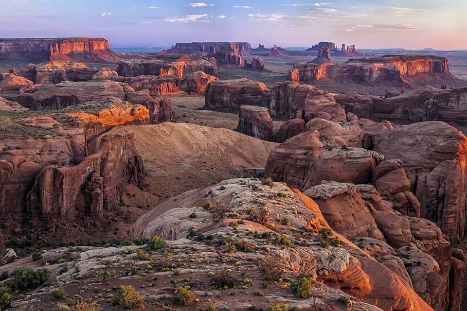
Well-known parts of the plateau have been showcased in this magazine before: the Canyon, Monument Valley and Sedona’s famous red rocks, to name a few. But the plateau as a distinct entity has rarely been featured in the 1,200-plus issues published thus far. Therefore, this centennial year of Arizona Highways is an ideal time to showcase the unique story of our nation’s, and our planet’s, most charismatic and colorful landscape.
THE NAME “COLORADO PLATEAU” is perhaps confusing to some: It comes not from the nearby Rocky Mountain state, but from the Colorado River, the master stream that drains its lofty heights. This great excavator of rock, along with its multitude of tributaries, has bequeathed a display of spectacular scenery with no comparison anywhere on the planet. And I have looked everywhere, visiting more than 90 countries in search of a possible “twin” to the Colorado Plateau. I’ve been fortunate, in my more than 50 years as a geologic educator, to learn from and about this wondrous land, sharing it with thousands of hikers, river runners, historians, artists and visitors from around the world.
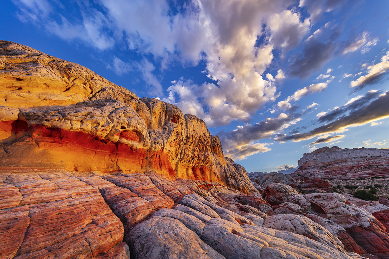
The first European-Americans to find the plateau, in their searches for gold or converts, deemed it “prison-like,” even “worthless.” Today, however, it’s embraced by tens of millions of visitors and residents who gravitate toward and gaze at its shocking beauty. Its beguiling topography sweeps boldly across large tracts of the Four Corners states, including the northern half of this, our nation’s sixth-largest state. Arizona is widely known for its iconic saguaro cactuses, dazzling desert sunsets and bright wildflowers. But it holds another genre of beauty, simply but daringly, in its rocks. These are not stones found in your garden; rather, these are vast and widely exposed layers of rock that stretch across the American Southwest for hundreds of miles, like paint spilled from a speeding pickup truck. The colors appear to come from within the rocks and stand brazenly beneath the rarefied air of its elevated terrain.
Forty-three percent of Arizona is on the Colorado Plateau, but most residents likely couldn’t describe it. Encompassing an enormous swath of land reaching from Central Arizona’s Mogollon Rim to Northern Utah’s Uinta Mountains, and from just west of Albuquerque to St. George, it is 130,000 square miles of sunbaked, naked earth — slightly smaller than Montana but larger than New Mexico, our fourth- and fifth-largest states, respectively. Within its boundaries are no fewer than 10 national parks, 20 national monuments, a handful of national recreation areas and tribal parks, scores of officially designated wilderness areas and a sprinkling of state parks, most of them established to preserve the world-class geology that draws visitors from around the globe.
Amid such bold proclamations made by its rocks, the vegetation here appears muted. But hardy, often colorful plants, together with copious piñon pines and junipers, provide relief to those who need greenery in their scenery. And a handful of mountain ranges rise into the alpine tundra; the two highest on the plateau, Utah’s La Sal Mountains and Arizona’s San Francisco Peaks, reach elevations of more than 12,000 feet. These mountains originated from magma, providing an invigorating diversion from the sea of red rocks that surrounds them. Although appearing static, the rocks stand in strong, silent testimony to our momentary existence, their unfolding story thankfully brought to life through the eyes of the geologist.
Technically, the plateau is one of 26 physiographic provinces that have been described in the continental United States. (If our country had been divided into states based solely on their unique geography, there would be 26 instead of 50.) The Colorado Plateau is bordered by two neighboring provinces: the Rocky Mountains to the north and east, and the Basin and Range Province, where the other 57 percent of Arizona is located, to the south and west. What makes the plateau unique is how five discrete but vital processes have acted in concert to create a sort of landscape symphony. Remove any one of them, and the Colorado Plateau would not exist.
FIRST, THIS IS A LAND OF WIDESPREAD and, for the most part, flat-lying sedimentary rocks; these (and the summertime cloudscapes) are what initially drew my heart to the plateau. Deposited in basins near the ancient edge of our continent, these stratified layers accumulated gradually, obeying the supreme force of gravity. The sediment eroded elsewhere from existing rocks, then was transported by various means to lie on a nearly featureless terrain. It was laid down in huge, sweeping dunes of windblown sand, or as mud on the banks of sluggish rivers. Often, the trackways of extinct animals are found in the now-lithified sediment. These strata provide a magic carpet of time travel through which we humans can learn about Arizona’s past, from times long before we came to discover their secrets.
Gradually, the sediment was buried to a thickness approaching 3 miles. Groundwater flowed through it, depositing cementing agents such as silica, calcium and iron. Occasionally, and much later, the layers were gently tilted a few degrees from horizontal, providing a slant pleasing to the eye of the artist and poet.
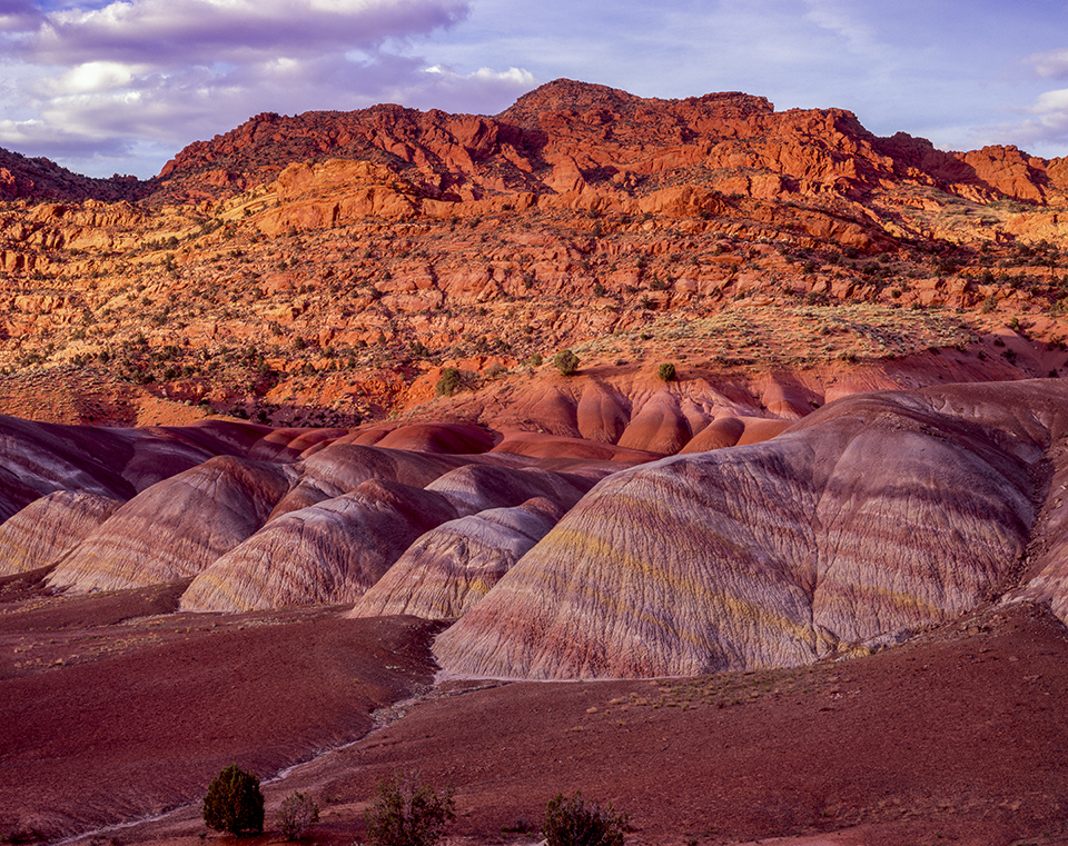
The second step in making the Colorado Plateau matchless involves how the rocks attained their variable and radiant colors. Names manifesting these myriad colors are splashed across maps in the region: the Painted Desert, Red Rock Country, the Vermilion Cliffs and the Kodachrome Basin, to name a few. These colors are derived from the oxidation state of iron within the rocks, creating luminous hues of red, orange, tan, buff, mauve, purple, even green. While most of the sediment is composed simply of clear white quartz (like that found on any modern beach), flecks of iron-rich minerals populate the layers here and there. When groundwater moved through the sediment, it dissolved the iron-rich minerals, coating each grain of sand or silt with a thin veneer of reddish iron. Surprisingly, these eye-popping colors result from less than 0.5 percent of iron, by weight, in the rock. If not for the color in the plateau’s rocks, there would be many fewer national parks here.
After these two processes, the gentle uplift of the strata is one of the most important components concerning the plateau’s origins. Importantly, this was achieved as a gentle, region-wide uplift that allowed the rocks to escape the intense warping and faulting that happened in the uplift of the Rocky Mountains. Thus, the plateau’s rocks evaded the extreme bending and breaking that occurred in other uplifted areas of our planet, such as the Alps, Himalayas or Appalachians. Rocks are often described as having “suffered” such deformations. But I had a professor at Northern Arizona University, when I was obtaining my geology degrees, who maintained that the rocks do not “suffer” them; rather, they enjoy it. Regardless, the vast area of sedimentary rock on the plateau has been uplifted in a manner that is not all that common, preserving the rock as mostly flat-lying but elevated in graceful, sweeping lines that seem to roll across the land.
The uplift of the plateau was a likely consequence of a thickened slab of ocean crust that was being shoved under the edge of our continent, a process called subduction. As the ocean slab was forced under, friction between it and the crust above caused a few areas to fold, warp and bend in steep angles, much like a throw rug when pushed across a hardwood floor and against a wall. These bends, called monoclines by geologists, provide some of the most spectacular and dramatic settings on the plateau. They are found on the eastern margins of the Canyon and Monument Valley, and most strikingly along the 100-mile-long Waterpocket Fold at Capitol Reef National Park in Utah. Many of the most remarkable and shocking landscapes are eroded into Colorado Plateau monoclines.
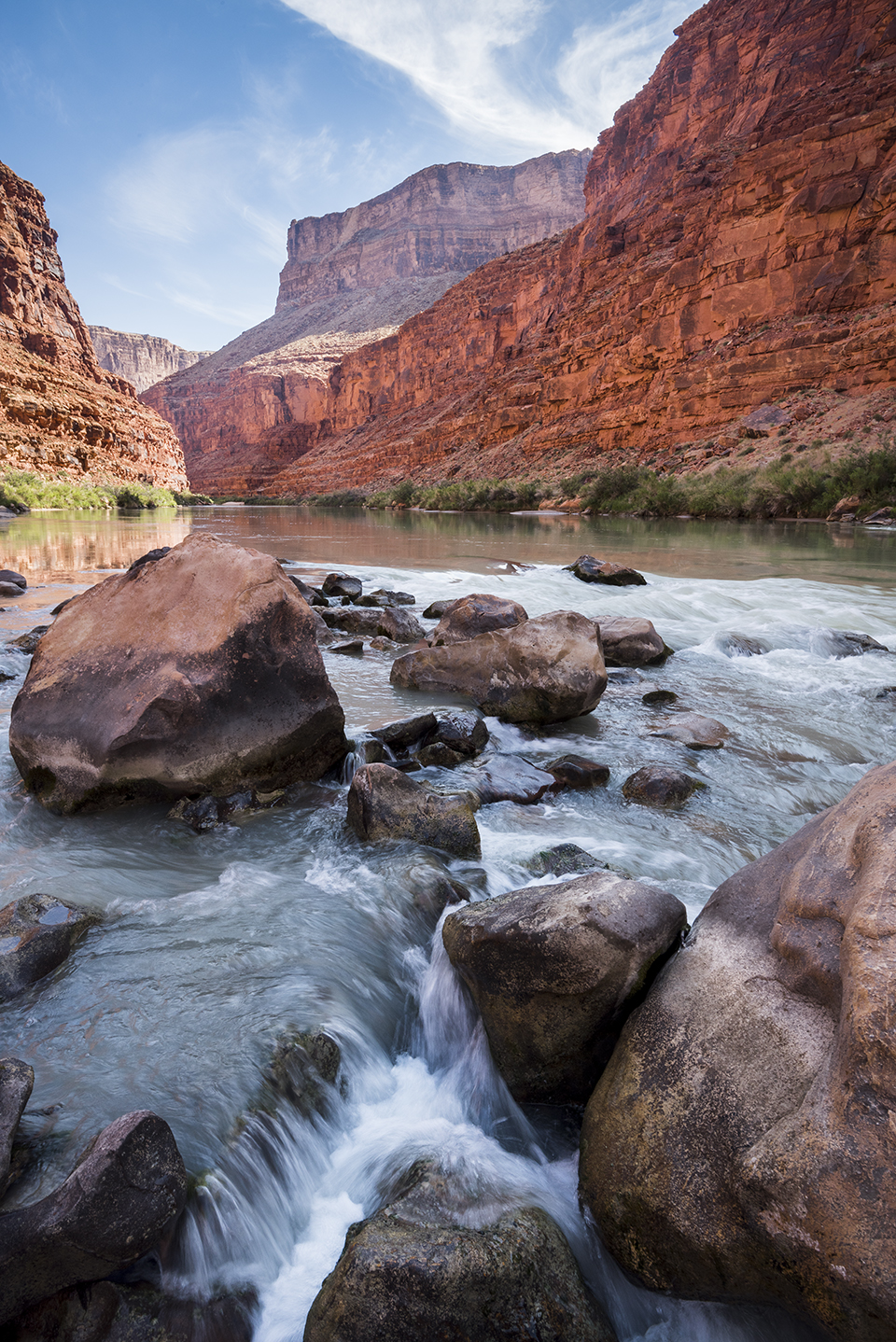
The last two elements contributing to this rock symphony may, at first, seem incompatible. First among these is that the uplifted rocks are deeply dissected by a few large rivers and their tributaries. This is what gives the Colorado Plateau its signature landscape element: numerous deep canyons. In Arizona, these include Oak Creek Canyon (and all canyons south of the Mogollon Rim), Canyon de Chelly and the grandest of them all, the Grand Canyon. In the other Four Corners states, such landforms are almost too numerous to mention but include Zion, Bryce and Glen canyons, as well as Lodore, Yampa, Desolation, Labyrinth, Stillwater, Westwater and Cataract canyons and the Black Canyon of the Gunnison.
Principal among these large plateau rivers is the great Colorado, which rises in Rocky Mountain National Park northwest of Denver. Before 1921, this waterway was known as the Grand River; its near-equal cohort, the Green River — originating in the Wind River Range in Wyoming — merged with the Grand in what later became Canyonlands National Park in Utah. Only when the confluence of these two great streams was attained was it then called the Colorado River downstream from there. These rivers embrace a multitude of tributary streams, cutting countless side canyons.
Perhaps surprisingly, the carving of these canyons is one of the most recent touches in the completion of this geologic masterpiece. Recent uplift raised the bed of the Colorado and its tributaries upward, to where it could slice into the uplifting mass. During exceptionally large floods, very large boulders rolled in the stream channels, assisted in the past 2.5 million years by voluminous meltwater issuing from the repeated melting of Rocky Mountain glaciers. These floods transported large, rocky debris that physically pounded the bedrock channels, eroding and deepening the canyons. The eroded material from the Rocky Mountains that carved these canyons now lies pulverized as newborn sediment on the floor of the Gulf of California. Endless cycles of recycling rock are the story of our planet: uplift, erosion, transport and burial, repeated again and again.
Remarkably, the Colorado likely did not have an outlet to the sea until as recently as 4 million to 5 million years ago. Before that time, the river may have ended in one or more freshwater basins, trapped in a similar manner as the Great Salt Lake in Utah is today. There is evidence that the former Grand River in Colorado was in place before 11 million years ago, but equal evidence exists that a river did not flow out of the Canyon or exit the western edge of the Colorado Plateau before 5 million years ago. Which begs the question: How can a river be more than 11 million years old in one place but less than 5 million years old in another? The answer is that the modern river has been cobbled together from separate and distinct ancestors. Rivers, like humans, are born, mature and eventually change.
Finally, and seemingly opposed to the presence of large rivers, is that the modern plateau is set within a dominantly arid environment, making these wonders free from a veil of vegetation that would hide it all. But even if all four of the previous conditions had been met, the absence of an arid environment would render this landscape completely changed. That’s because in arid environments, limestone stands solid, like cold, hardened steel. If it were placed in a tropical setting, the humidity and chemical reactions would cause it to “melt” away. Here, it protects the layers of rock that lie beneath it — in fact, the Canyon is as deep and spectacular as it is because of a capping layer of resistant limestone.
One might wonder: How can large rivers exist in an arid environment? This is because more than 70 percent of the Colorado’s runoff originates in the lofty headwaters of the Rocky Mountains. Rising below the Continental Divide, the river system is fed by abundant snowfall on its long path toward the Gulf of California. A few other locations on our planet have large rivers in arid environments; these include the Nile in Africa and the Tigris and Euphrates in Iraq. However, these areas lack important elements: They do not contain colorful sedimentary rocks, and being located near sea level, they have not been uplifted.
THERE YOU HAVE IT. A surprising and delightful landscape was formed by colorful, mostly flat-lying sedimentary rocks, gently uplifted and carved by a few large rivers and their tributaries and set within an arid desert environment. It is perhaps noteworthy that the Native peoples of the Colorado Plateau were able to eke out a long-lived presence there, given the harshness of the environment and the difficulty of the terrain. And as successful as they were, they were nevertheless subjected to the whims of its unpredictable and variable climate, and their fortunes rose and perished in the wind.
Curiously, when agriculturally focused European-Americans encountered the Colorado Plateau, they were repulsed by it, leaving it undeveloped and spared from the plow and the tax man. How strange that the plateau’s exclusion from the “manifest destiny” policy of the 19th and 20th centuries should have favored the plateau in being a source of inspiration in art, outdoor recreation, wilderness ethics and the idea of preservation.
I’ve been privileged to have had the Colorado Plateau as the ultimate muse and classroom and a source of rejuvenating recreation. This, then, is my love letter to the plateau — its colorful rocks, its canyons and its lessons in Earth history.