
When European immigrants ventured into the southwest corner of Arizona Territory in the late 19th century, they considered the Sonoran Desert a barren wasteland and saw little of value except the gold, silver and copper they were seeking. But eventually, the land became treasured for something else: cactuses. In 1937, President Franklin Roosevelt established Organ Pipe Cactus National Monument to protect one of the richest Sonoran Desert habitats in the United States. And in 1976, the park was named an International Biosphere Reserve for its abundance of unique plant life. Within the monument’s 330,000 acres are 31 different cactus species, including the only large stands of organ pipe cactuses in the nation. There also are vast expanses of saguaros and rarer senita cactuses.
Day 1
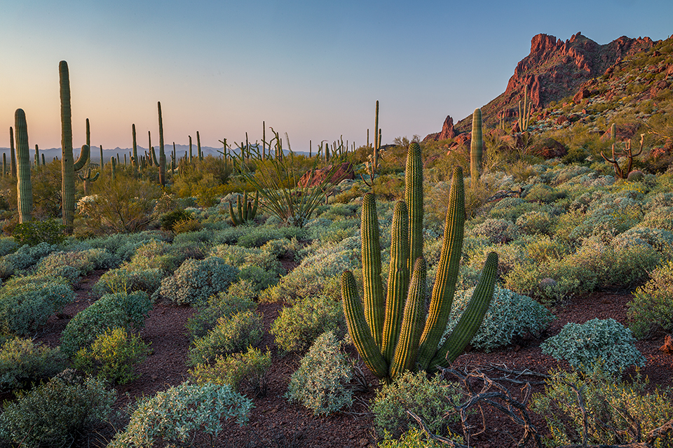
Start your Sonoran Desert weekend on the 21-mile Ajo Mountain Drive, a graded loop road east of State Route 85 that leads into the towering Ajo Range. Pick up a free interpretive guide for the route at the park’s visitors center. The drive itself takes about two hours, but you’ll want to allow plenty of extra time for hiking, picnicking and cactus gazing along the way. “This drive is one of my favorite things to do in the park — you get a little bit of everything,” says Karen Ceballos, a ranger at the monument. “It showcases so many different plants and takes you way up into the mountains with amazing views into Mexico and of organ pipe stands.”
From park headquarters, make your way northeast on the one-way loop through cactus-studded basins, with Tillotson Peak on your left. Dead ahead are the jagged volcanic cliffs of the Ajo Range and 4,800-foot Mount Ajo. The road twists its way up to the base of the sheer rhyolite cliffs and the Arch Canyon Trailhead. Located around the halfway point of the drive, this is a great place to stretch your legs. Scramble up the 1-mile path that leads to the entrance of the narrow canyon, where there are two natural arches: a 90-foot-wide span, and a smaller arch on top of it. The picnic area at the trailhead is a scenic lunch spot.
Continuing on the drive, the road loops back to the south and soon reaches the Estes Canyon-Bull Pasture Trailhead. Ceballos recommends the Bull Pasture loop route as the best hike in the park. The roughly 4-mile (round-trip) route climbs 900 feet up to the grassy Bull Pasture Saddle, where ranchers once grazed their cattle. The loop then circles back through the riparian oasis of Estes Canyon. “I love this hike,” Ceballos says. “It is a bit of a strenuous climb, but you are rewarded with incredible views of Mexico’s Cubabi Mountains and Mount Ajo. And on the way down through Estes Canyon, there are a lot of wildlife and birding opportunities.”
Once you’re back at the car, continue driving southwest, into desert basins flanked by the Diablo Mountains, until you return to park headquarters. If you can snag one of the four campsites at Alamo Campground, pitch your tent for the night at this primitive site, which is north of park headquarters and 3 miles east of SR 85. At sunset, the cliffs of the Ajo Range glow pink and orange. The sites are first come, first served, so you may want to claim your campsite before tackling Ajo Mountain Drive. Otherwise, there are plenty of sites that can be reserved in advance at the park’s developed Twin Peaks Campground, next to the visitors center.
Day 2
Spend the day on a leisurely drive along 37-mile Puerto Blanco Drive as it winds its way around the Puerto Blanco Mountains and parallels the U.S.-Mexico border. This road is less traveled than Ajo Mountain Drive and provides a chance to experience the expansive space and quiet of the desert in utter solitude. Some sections of the route are rutted gravel, and a high-clearance vehicle, such as an SUV or truck, is recommended.
From the visitors center, head north on Puerto Blanco Drive; in about 4 miles, you’ll arrive at the Red Tanks-Senita Basin Trailhead. A 3-mile ramble through this flat desert wash will take you through the natural water catchment Red Tanks Tinaja, a desert wildlife oasis. The path then leads into Senita Basin, where a 1-mile loop route offers the chance to see wild senita cactuses — which, in the United States, exist only in Organ Pipe.
Back on Puerto Blanco Drive, the road becomes gravel and one-way as you wind around Pinkley Peak. Drift west, then south through an endless green desert until you reach a “T” intersection at the U.S.-Mexico border. Hang a right on the short spur road to visit Quitobaquito Springs. This rare riparian area includes a man-made pond that attracts abundant bird life. It also is home to three species that occur naturally nowhere else in the U.S.: the Quitobaquito spring snail, the Sonoyta mud turtle and the desert caper. Enjoy a picnic here and contemplate that archaeological evidence shows humans have been visiting the springs for more than 16,000 years.
Continue along the border to the junction with SR 85, then make your way back to the visitors center. After setting up camp at Twin Peaks Campground, enjoy one of the best sunset perches in the park on the Desert View Trail. The 1.2-mile loop trail leading from the campground climbs a ridge with benches; from there, you can watch the desert bajadas below radiate with the day’s last light as stands of organ pipes turn a neon green.
Day 3
Top off your Organ Pipe adventure with one last hike. The 2.2-mile (one way) Victoria Mine Trail begins at the campground and leads to the best-preserved mining ruins in the monument. The Victoria Mine produced gold and silver from the 1880s to the 1910s, although mining continued sporadically until the monument received wilderness designation in 1976. The stone remains of a general store are still standing, and abandoned mine shafts and tailings piles surround the store as a reminder of a previous era.