“Wilderness” is defined in the Wilderness Act as “an area where the earth and its community of life are untrammeled by man, where man himself is a visitor who does not remain.” The act protects some of the prettiest places in the United States. In Arizona, 90 designated wilderness areas comprise more than 4.5 million acres. Our photographer went to every single one of them.
A Portfolio by Jonathan Buford
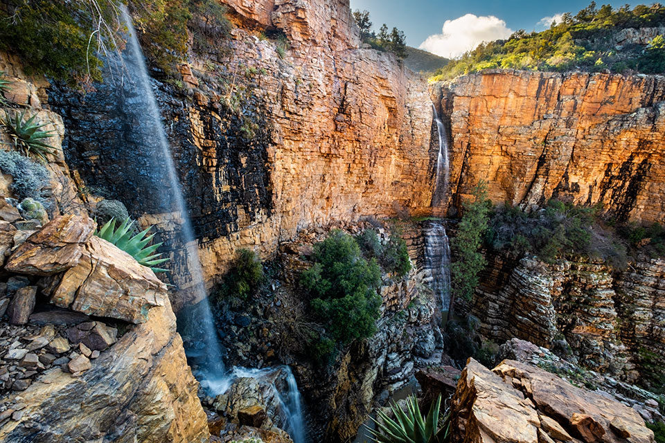
Healthy agaves punctuate a view of two remote seasonal waterfalls in the Mazatzal Wilderness, southwest of Payson.
EDITOR’S NOTE: Jonathan Buford grew up in Ohio, but after he moved to Arizona in the early 2000s, he fell in love with the concept of wilderness — and with landscape photography. Those two passions merged in his years-long effort to visit and photograph all 90 of Arizona’s federally designated wilderness areas, a small portion of which are pictured in this portfolio. “I wanted to see them all, but more than that, I wanted to understand them all,” he recalls. “Back then, the state seemed so vast and insurmountable, but I had the audacity to believe I could do it. My main goal is to show future generations what these places look like, so they can better understand things like erosion and degradation. And I want to create stewards of the land — and remind everyone that we play a role in protecting these places.” Buford also notes that this country’s
wilderness preservation system is fairly unique. “Systemic ways of preserving parcels of natural landscape, while keeping them public, are rare,” he says. “We’re more lucky than we know — and more wild than we believe. I’d like to influence that wild side in everyone.”
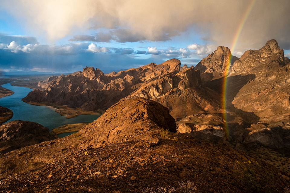
A rainbow appears at sunset at a Colorado River overlook in the Havasu Wilderness, northwest of Lake Havasu City and just west of State Route 95. Occupying 17,801 acres in Arizona and California, Havasu protects populations of desert tortoises, bighorn sheep and a variety of birds that inhabit its rugged desert terrain. “I wandered this moonscape for two days and noted that this perch would be a great sunset view,” Buford recalls.
Sunrise lights the tops of oddly shaped rock formations in the Cottonwood Point Wilderness, a place Buford calls “truly of another planet.” Located east of Colorado City along Arizona’s state line with Utah, this 6,860-acre wilderness area protects two jagged rock “peninsulas” that curve around Cottonwood Canyon. There are no established trails, but backpackers and hikers are drawn to its deep, narrow canyons. “There are so many things to photograph up there, but in this scene, more is less,” Buford says.
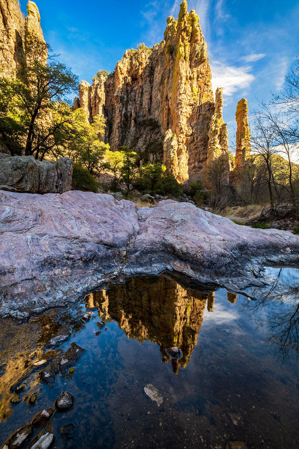
“Anytime you’re able to have perennial water and high cliffs in the same image, it’s a real treat,” Buford says of this sunset shot from the 7,499-acre Pajarita Wilderness, along the U.S.-Mexico border. “I wanted to avoid being a shutterbug while visiting, and I found this scene to be a strong visual representation of the area.” Despite its relatively small size, Pajarita is home to more than 660 plant species, including 17 found nowhere else on Earth. It’s just southeast of the well-preserved ghost town of Ruby.
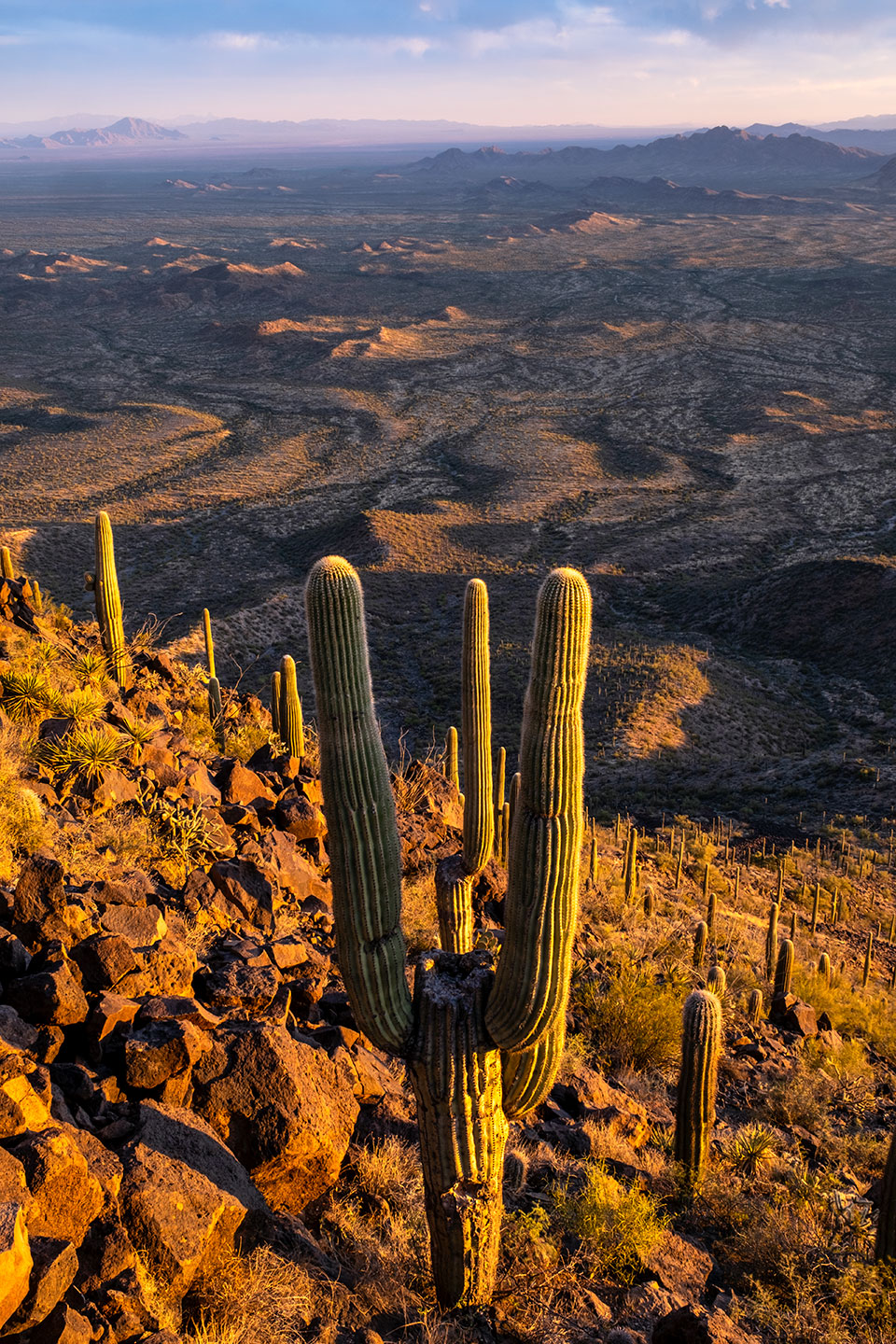
At sunset, a touchdown-signaling saguaro anchors a view from atop the Table Top Wilderness, just south of Interstate 8 between Gila Bend and Casa Grande. “This may just be the densest saguaro forest in Arizona,” Buford says, adding that this summit offers an incredible 360-degree view of the surrounding Sonoran Desert. Measuring 34,400 acres, the wilderness area has been part of Sonoran Desert National Monument since 2001.
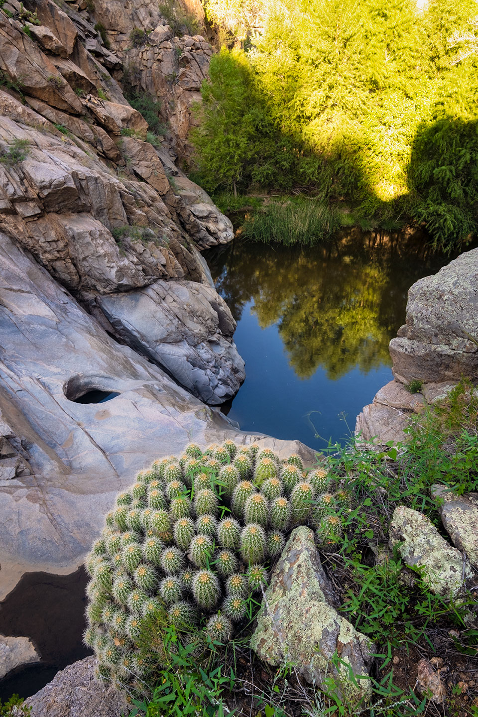
During his visit to the Castle Creek Wilderness, Buford wanted to photograph the waterfall just below this healthy hedgehog cactus. “When I found the flow to be too minuscule to shoot, I switched to telling the story of this lush riparian pool that retains water year-round,” he says. This wilderness area, which covers 25,457 acres, is on the eastern flank of the Bradshaw Mountains, just east of Crown King.
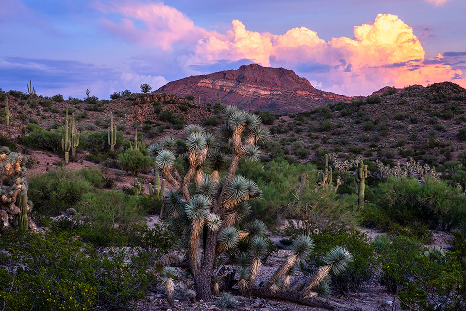
Joshua trees, typically a Mojave Desert plant, mingle with Sonoran Desert saguaros in a sunset view of the 8,300-acre Tres Alamos Wilderness, just off U.S. Route 93 northwest of Wickenburg. “The monsoon clouds catching the sunset glow can be a rare sight in this arid region, so I was grateful to have them in this scene,” Buford says.
Healthy agaves punctuate a view of two remote seasonal waterfalls in the Mazatzal Wilderness, southwest of Payson. Photographer Jonathan Buford hiked 20 miles to reach the upper rim of these falls; for scale, he notes that the ponderosa pine below the waterfall in the background is a fully grown tree. Various trails into this 250,760-acre wilderness area can be reached via forest roads along State Route 87 (the Beeline Highway).