
“Switchback” rhymes with “six-pack.” They’re not interdependent words, but, like mashed potatoes and gravy at Thanksgiving, they’re an important combination on this trail. Not at the same time, though. The switchbacks help shuttle hikers to a summit that rises almost 2,000 feet above the trailhead. And the six-pack … well, that’s the reward for conquering a route that’s steep, rocky and grueling. It’s a workout. And so is getting there.
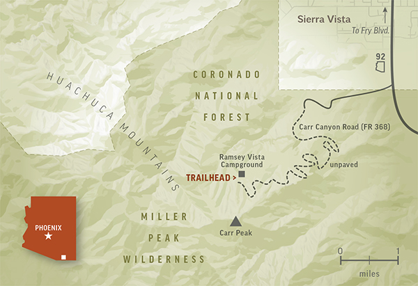
For the first few miles, Carr Canyon Road, the final approach to the starting point, is doable in a station wagon, but the polished surface quickly gives way to a jagged mess. Like rows of shark teeth, the rocks in the road will shred your tires if you’re reckless. What’s worse, it’s a narrow, one-lane ordeal with steep drop-offs and no guardrails. If you’re afraid of heights or generally faint of heart, you might want to skip this hike. But if you have high clearance and a high threshold, this is one of the best trails in Arizona. It throws a lot of different looks along the way, and the views from the top are distant and spectacular.
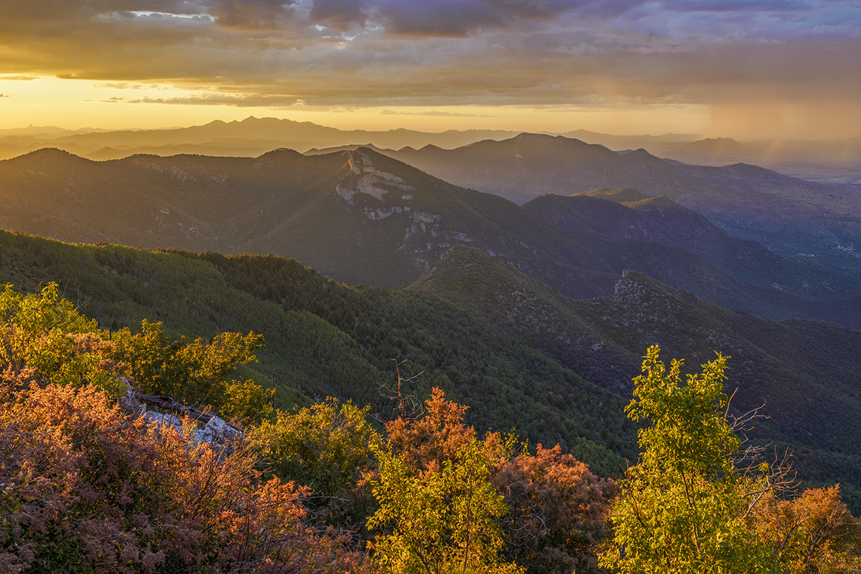
The hike begins at Ramsey Vista Campground, which is tucked in the trees at an elevation of 7,400 feet — there’s a lot to love in the Huachuca Mountains, and this campground is high on the list. From the first step, just south of the restroom, the trail starts climbing and never lets up. Random yuccas and tunnels of manzanitas lead to a small forest of big trees that have been spared from fires that burned the area in 1977, 1991 and 2011. It’s hard to be hopeful when so many of the state’s natural wonders are going up in flames, but the recovery you’ll see on this trail is a good reminder that Mother Nature never gives up. The new growth, including young Emory oaks and Arizona black walnuts, is a testament to that — in early November, there might even be some lingering fall color.
After about 20 minutes, you’ll cross into the Miller Peak Wilderness, which protects 20,190 acres and nearly 80 species of mammals, including coatimundis, javelinas, black bears, mountain lions and Coues’ deer. There are birds, too. About 170 species, 14 of which are hummingbirds. A few minutes later, you’ll come to an intersection with the Old Sawmill Springs Trail and hit the first of the switchbacks. They’re long, and they eat up a lot of elevation.
Like most areas hit by fire, the north slope of the Huachucas is a patchwork of old trees, new trees and open space. The switchbacks cut through all of the different zones and, about an hour in, lead to the first new-growth aspens. The clusters are thick, like a jungle, and mixed with Apache pines. A few hundred feet later, you’ll come to a giant Douglas-fir that’s survived every one of the fires.
Just beyond the big fir, the trail starts to wind in a clockwise direction around the base of the peak. Ten minutes later, you’ll get your first glimpse of Mexico. And closer in, to the southeast, you’ll see the Miller Canyon Trail, which connects with the Arizona Trail near Bathtub Spring.
From this point, you’ll need to start looking toward your feet and to the right for a sliver of a trail that veers to the northwest. At the time of this writing, there wasn’t a sign, but if there had been, it would have read, “Carr Peak Spur Trail #108.” If you’re marking your mileage, the intersection is about 2.5 miles in. Keep your eyes peeled.
If you miss the connection, you’ll eventually intersect the Crest Trail, which is about a mile away. If you make it, you’ll scramble up a steep slope for a quarter-mile to the top. As payoffs go, Carr Peak offers one of the best. From the summit, you can see Mexico to the south, New Mexico to the east, the Rincon Mountains to the north and the Santa Rita Mountains to the west. The views are the highlight of the hike. And if you’re lucky enough to have a campsite and a six-pack at the trailhead, even better.
TRAIL GUIDE
Length: 6 miles round-trip
Difficulty: Strenuous
Elevation: 7,379 to 9,239 feet
Trailhead GPS: N 31˚25.688', W 110˚18.209'
Directions: From Fry Boulevard in Sierra Vista, go south on State Route 92 for 6.8 miles to Carr Canyon Road (Forest Road 368). Turn right onto Carr Canyon Road and continue 7.7 miles (the pavement ends after 1.3 miles) to Ramsey Vista Campground. The trailhead is located near the restroom.
Special Consideration: The Coronado National Forest has issued a warning that smugglers and immigrants entering the country illegally may be in the area.
Vehicle Requirements: A high-clearance vehicle, such as an SUV or truck, is recommended.
Dogs Allowed: Yes (on a leash)
Horses Allowed: Yes
USGS Map: Miller Peak
Information: Sierra Vista Ranger District, 520-378-0311 or fs.usda.gov/coronado