
Kachina Peaks Wilderness, Flagstaff
Humphreys Peak is the king of the hills in Arizona. It’s the pinnacle. The highest point in the state. If you can make it to the summit, which tops out at 12,633 feet, you’ve conquered all there is to conquer — from a hiking perspective, anyway. Making it up and down is certainly something to be proud of, but, despite its stature, the Hump is not the most difficult hike in Arizona. The North Kaibab Trail, from river to rim, is more challenging. And so are others. Still, this one ranks right up there.
The trail begins at the west end of Arizona Snowbowl’s lower parking lot. Snowbowl is the local ski resort. After a short climb through a lush meadow of grasses and wildflowers, you’ll start to smell the evergreens as the trail enters the deep forest. About the time the sky disappears, you’ll be crossing into the Kachina Peaks Wilderness. Humphreys Peak, along with three others — Agassiz (12,365 feet), Fremont (11,969 feet) and Doyle (11,460 feet) — comprise the Kachina Peaks, which are sacred to the Navajo, Hopi, Havasupai and Zuni people.
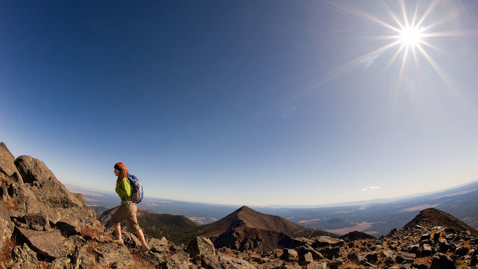
Although reaching the summit is the high point of this hike, there’s a lot to see in the process, including thousands of acres of Engelmann spruce, corkbark firs, ponderosa pines and even some aspens. Wildlife is plentiful, too. Look for Western bluebirds, chickadees, white-throated swifts, wild turkeys, porcupines, mountain lions, bobcats, elk, black bears and deer. The most common animal, however, is the human being. This is a popular trail, but because of the lack of oxygen, hikers tend to spread out evenly.
From the edge of the forest, the well-maintained trail climbs for several miles to the Agassiz Saddle, which connects Humphreys Peak and Agassiz Peak. This is also where the Humphreys Trail intersects the Weatherford Trail. You’ll be heading uphill, but this is a good place to look around. Up to this point, most of the hike has been a tunnel through the thick alpine forest. The saddle affords an opportunity to see what you’ve been missing. Of course, the views from the top are even better.
Before you get there, though, you’ll notice that the tree line and oxygen level have thinned. The saddle marks the beginning of Arizona’s sole tundra region. Up there, only bristlecone pines survive, and even those eventually disappear. Like all tundra regions, this one is extremely fragile, which is why the U.S. Forest Service strictly prohibits camping and off-trail hiking. Perhaps more than anything, the goal is to protect the San Francisco Peaks groundsel (Packera franciscana), an extremely rare plant that grows nowhere else in the world.
Watch your step, and gear up for the last mile or so to the summit. It’s the most challenging stretch of the hike. It’s worth the effort, though. At 12,633 feet, you’ll be able to see the Grand Canyon and the Hopi mesas to the north, the White Mountains to the east and Oak Creek Canyon to the south. And overhead, you might see some of those white-throated swifts, which feed on the insects that’ll be swarming around your face. Your biggest concern, however, won’t be the bugs, but the weather.
Around the peaks, thunderstorms and their deadly lightning strikes can roll in almost without warning. Don’t press your luck, and remember the first rule of mountain-climbing: Making it down is more important than making it up. After all, there’s no point in conquering the king of the hills if you’re not going to be around to brag about it.
Length: 9 miles round-trip
Difficulty: Strenuous
Elevation: 8,800 to 12,633 feet
Directions: From Flagstaff, go north on U.S. Route 180 for 7 miles to Forest Road 516 (Snowbowl Road). Turn right onto FR 516 and continue 6.3 miles to the lower parking lot. The trailhead is at the far end of the lot.
Vehicle Requirements: None
Dogs Allowed: Yes
Horses Allowed: No
USGS Map: Humphreys Peak
Information: Flagstaff Ranger District, 928-526-0866 or http://www.fs.usda.gov/coconino