
A doe is a deer. A female deer. And there are many in the wilderness surrounding Sedona, silently tiptoeing through the drops of golden sun. At some point, presumably, one of them — or maybe several — did something out of the ordinary and inspired the locals to name a flat-topped mesa after her. The origin story of Doe Mountain isn’t clear, but there’s no confusion about what’s in store on top. Only a hot air balloon offers a view as vast as what you’ll see on the upper end of this trail.
“Doe Mountain is a short climb with epic 360-degree views and great ledges for photo ops,” says Kegn Marissa Hall, a Sedona native and avid adventurer. “It’s a local favorite.”
It’s easy to see why. It’s a beauty.
What’s more, the trail recently went through an extensive upgrade — at a cost of $130,000 — that included the installation of rock steps, retaining walls and erosion control, as well as two new loop trails on top. The loops extend an otherwise short route to 3 miles. It’s still a quick trip, but so is the trail to Cathedral Rock. “Better short and sweet than long and lax,” the Scots say.
This short hike shares a parking lot with the Bear Mountain Trail — perhaps their names are rooted in the same 19th century tale. From the pavement, the freshly groomed track begins an immediate ascent. The dirt is red and the route is well marked, like the zebra crossings in Piccadilly Circus. Within a few minutes, you’ll come to an intersection with the Aerie Trail, which works in tandem with the Cockscomb Trail to create a loop around the base of the mountain.
Continuing up, veer right, then left, and follow the rock steps up the north side of the mountain to the switchbacks, which are gradual and effective. The trail restoration is especially noticeable along this stretch. Another thing you’ll note is the quiet nature of things, despite the mountain’s proximity to the Uptown hubbub.
About 20 minutes in — 0.7 miles — the trail cuts through a narrow chute in a massive rock and arrives at the top of the mesa. You have three choices at this point: 1) go forward to Doe Overlook,
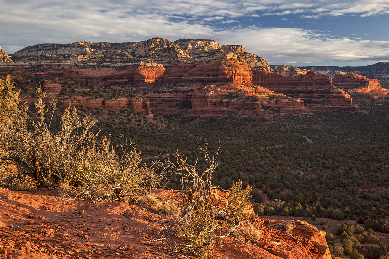
2) turn right for the South Loop, or 3) go left for the North Loop. The locals like to go left, and by following in their footsteps, you’ll get a distant look at Jerome and a closer look at Bear Mountain and Fay Canyon.
Ravens and Steller’s jays voice their displeasure with the uninvited. In spite of their noise, you’ll see manzanitas, junipers and other high-desert vegetation as you wind around the west side of the mesa and move north. It’s there that civilization enters the picture: Two roads can be seen, and homes are scattered here and there. Turns out, Sedona is not virgin territory anymore, and that draws some boos.
For a long time, the city has been disparaged for its growth. “They should have made this place into a national park,” people say. To be sure, that would have been nice, but the same thing could be said about so many other picturesque places — Aspen, Door County, the High Peaks region around Lake George, the hilly promontory overlooking the Mediterranean where the Phoenicians built Carthage.
People clutter landscapes, but not all of them. The top of Doe Mountain remains untouched. And the landscape surrounding it is mostly clear. It’s not a national park, but it’s a healthy antidote to that empty feeling of what might have been. You’ll feel some of that as you hike around to the east side and come to Doe Lookout.
From there, you can take the shortcut back to the west side, or merge onto the South Loop. The locals take the loop, which is less defined than its counterpart; however, cairns — a useful tool, but a violation of Leave No Trace — mark the way. As you head back to the west side and the final descent, you’ll see Mescal Mountain, Wilson Mountain and the Cockscomb, the southernmost formation in Red Rock Country.
What you won’t see are deer. You could, but you probably won’t. And it won’t matter. The solitude, scenery and drops of golden sun will do.
Trail Guide
Length: 3 miles round-trip
Difficulty: Moderate
Elevation: 4,620 to 5,067 feet
Trailhead GPS: N 34˚53.591', W 111˚51.898'
Directions: From the roundabout intersection of state routes 179 and 89A in Sedona, go southwest on SR 89A for 3.1 miles to Dry Creek Road. Turn right onto Dry Creek Road and continue 2.7 miles to Boynton Pass Road. Turn left onto Boynton Pass Road and continue 1.5 miles to Forest Road 152C. Turn left onto FR 152C and continue 1.2 miles to the trailhead parking area, on the left.
Special Consideration: A $5 day pass is required.
Vehicle Requirements: None
Dogs Allowed: Yes (on a leash)
Horses Allowed: No
USGS Maps: Wilson Mountain, Loy Butte
Information: Red Rock Ranger District, 928-203-2900 or fs.usda.gov/coconino