
Mogollon Rim, Coconino/Apache-Sitgreaves National Forests
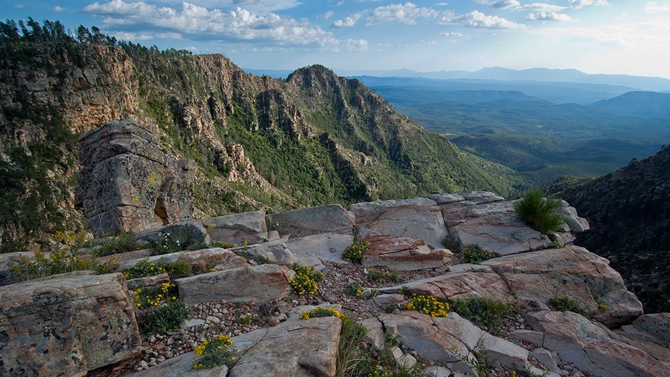
The Mogollon Rim. That’s the biggest reason you’ll want to make this drive. Although there are different opinions on how to pronounce the name — Spanish scholars go with “mo-go-yawn,” locals use “muggy-on” — everyone agrees that “the Rim” is impressive.
Measured in thousands of feet and hundreds of miles, it’s a massive wall of rock that begins near Arizona’s border with New Mexico and stretches diagonally across most of the state. Through the lens of a camera, a set of binoculars or your own baby blues, the views from the top of the Rim are stunning, and on a clear day, you can see all the way to Mount Lemmon.
The vistas steal the show, but there’s a lot to see along Forest Road 300, which can be approached from the east, near Woods Canyon Lake, or from the west, just north of Strawberry. This listing is written from the west, and it begins with an uphill climb through a thick pine forest — the Mogollon Rim is home to the world’s largest stand of ponderosas. After 1.2 miles, FR 300 intersects what used to be the General Crook Trail, a historic wagon route that was used in the 1870s and 1880s to provide logistical support for General George Crook in the U.S. Army’s war against the Apaches.
From there, the gravel road winds downhill to an area of grassy meadows crowded with tall evergreens. It’s a beautiful place to pitch a tent. Hardwoods and spruce start mixing in after that. You’ll also start seeing the first of many worthwhile side trips: Potato Lake, Lee Johnson Spring, Kehl Springs Campground. Then, after 7.5 miles, you’ll get to the dead zone of the Dude Fire.
The fire was sparked by a bolt of lightning on June 25, 1990, and within a few hours, it had become one of the deadliest and most destructive fires in Arizona history. In addition to the obliteration of more than 24,000 acres, six firefighters lost their lives. Only the Yarnell Hill Fire (June 2013) was worse in that regard. Today, the effects of the Dude Fire are still obvious. There’s very little new growth, other than grass, but the long views to the south help mitigate the damage.
Also, the fire zone makes up only a small stretch of FR 300, and at the 10.2-mile mark you’ll leave it behind and re-enter the beautiful. The rest of the route epitomizes the purity of nature, and still measures up to Captain George M. Wheeler’s description of the Rim in the late 1800s: “Mountain, forest, valley and streams are blended in one harmonious whole,” he wrote. “Few worldwide travelers in a lifetime could be treated to a more perfect landscape, a true virgin solitude, undefiled by the presence of man.”
Heading east, that perfect landscape includes Crackerbox Canyon and the Arizona Trail, one of several great hikes on the Rim. Another keeper is the Houston Brothers Trail, which shows up after 16.2 miles. Barbershop Canyon is just beyond that, followed by the Myrtle Trail and turnoffs to Lost Lake and Knoll Lake. Add them to the list of great side trips.
Moving on, about 25 miles in, the Rim Road, as it’s known, crosses from the Coconino National Forest into the Apache-Sitgreaves National Forests. The transition isn’t important except that it coincides with a large meadow dotted with young ponderosas. It’s nice to see the new growth. The upper trailhead for Horton Springs is ahead on your right, and a few miles later, you’ll arrive at the turnoff for Bear Canyon Lake, one of the Rim’s premier recreation areas — go for the camping, hiking and fishing. Of all the detours, this one deserves some real consideration.
Aspens, evergreens and panoramas mark the home stretch to Woods Canyon Lake, where the scenic drive comes to an end. You won’t want it to end, though. In fact, if you could pick one place to break down, get lost or drop out, Forest Road 300 would be it. Wildlife sightings (elk and mule deer in particular) are common, the cool pine forest is refreshing, the vistas are remarkable … no matter how you pronounce it, the Mogollon Rim is one of the most scenic drives anywhere.
Note: Mileages are approximate.
Length: 43.3 miles one way
Directions: From Payson, go north on State Route 87 for 28.5 miles to Forest Road 300. Turn right onto FR 300 and continue 43.3 miles to State Route 260.
Vehicle requirements: None
Information: Mogollon Rim Ranger District, 928-477-2255 or www.fs.usda.gov/coconino; Black Mesa Ranger District, 928-535-7300 or www.fs.usda.gov/asnf