
Mingus Mountain, Prescott National Forest
On May 15, 1920, Aldo Leopold sent an inspection memorandum to the supervisor of the Prescott National Forest. Among the many subjects he addressed was “roads and trails.”
“I understand that practically no road or trail money has been spent on the Prescott so far,” he wrote. “I believe the situation might become exceedingly embarrassing unless we immediately set to work to remedy it.”
A century later, “the Prescott” has one of the best trail networks in Arizona, including 17 trails on Mingus Mountain, plus two more in the nearby Woodchute Wilderness. Despite its high elevation and parklike forests, none of the trails on the mountain attract a long queue of hikers. In fact, you might have the Coleman Trail all to yourself.
The route begins at the end of a primitive forest road on the southern end of the Mingus Mountain Recreation Area, which offers campgrounds, a small lake, a picnic area and a hang glider launch site — operated by the Arizona Hang Gliding and Paragliding Association, it’s considered the premier launch site in the state. Another noteworthy sideshow is the Mingus Mountain Lookout Tower, which was built in 1935 and added to the National Register of Historic Places in 1988. It rises 60 feet above the mountaintop.
From the trailhead, the route heads southeast through an open forest of ponderosa pines and alligator junipers. After exactly 2 minutes and 18 seconds, you’ll see a wooden post on your left, butted against a young ponderosa. There’s a sign on the post that marks the way for Trail 108, which is the numerical ID for the Coleman Trail. Unfortunately, the sign is on the wrong side of the post, making it easy to walk right by if you’re unaware. Usually, the Prescott National Forest does an excellent job of marking its trails, but this is an unusual exception. What’s worse, it’s the only sign you’ll see on the trail until you get to the other end.
Nevertheless, if you set a timer, you’ll find the post, as well as its hidden sign. When you get there, turn left and follow the trail as it parallels an old barbed-wire fence for a few hundred yards. Because the forest floor is open, there’s a chance you’ll see some deer. You’ll also get a view of the southern horizon through the trees, which now include manzanitas and Gambel oaks. It’s the alligator junipers, though, that steal the show on this hike. According to the arboretum at Northern Arizona University, “The Prescott National Forest lays claim to the largest measured alligator juniper, which is 46 feet tall and is 27 feet, 4 inches around.” You won’t see anything quite that big on this trail, but there are some ancient giants along the way — the oldest gators can live to be 800 years old.
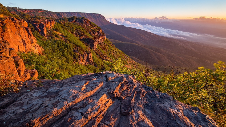
Continuing on, the path transitions from a rocky two-track to a needle-covered single track. The ponderosas are more numerous here, but they’re all second growth. Most of the old-growth trees were either logged out or lost in the Mingus Mountain Fire, which burned 14,000 acres in 1956. Still, it’s a beautiful forest that fills the space to the edge of the Mingus Rim, where the trail begins its steep descent to the south.
As you make your way, you’ll get a glimpse at some of the well-known landmarks to the north, including the Verde Valley, Sedona and the San Francisco Peaks. It’s similar to what you see on the Woodchute Trail, but the look is fleeting. Soon after, you’ll start seeing Forest Road 413 — the turnaround point — in the depths of the canyon below. It’s a long way down, which is why this hike is rated “strenuous.” In the last half-mile, the trail drops almost a thousand feet. It’s easy going down; however, like hiking into the Grand Canyon, you’ll have to reclaim that elevation on the way back.
But first you’ll have to get to the bottom, and that’s complicated by the rocky switchbacks that zigzag the steep slope. Your eyes will be drawn to the spectacular views of the lush, green hillsides, but you’ll need to stay focused on your footsteps. Like piranhas in the Amazon, the rocks will swarm your feet and do all they can to unhinge your ankles. Their appetite is insatiable, so beware as you make the downhill run to the trail’s end. There’s no real payoff when you get there, but there is a forest road. And a trail sign. Two things Aldo Leopold was hoping for back in 1920.
Length: 4.4 miles round-trip
Difficulty: Strenuous
Elevation: 7,619 to 6,615 feet
Trailhead GPS: N 34˚41.284', W 112˚07.166'
Directions: From Jerome, go south on State Route 89A for 7.6 miles to Forest Road 104 at Mingus Pass (elevation 7023 feet). Turn left onto FR 104 and continue 2.5 miles to the Mingus Mountain Campground. From the campground, go south on Forest Road 104A (take the right fork) for 0.6 miles to the trailhead near the radio facilities. Parking is limited.
Vehicle Requirements: A high-clearance vehicle, such as an SUV or truck, is recommended on Forest Road 104A.
Dogs Allowed: Yes (on a leash)
Horses Allowed: Yes, but portions of the trail are steep and not suitable for horses.
USGS Map: Cottonwood
Information: Verde Ranger District, 928-567-4121 or fs.usda.gov/prescott