
There are 714 biosphere reserves in the world. And 28 in the United States. There’s one in Arizona. It was established in 1976 at Organ Pipe Cactus National Monument as “a pristine example of an intact Sonoran Desert ecosystem.” The purpose of the reserve, which was designated by UNESCO, is to provide a natural laboratory for scientists to better understand the Sonoran Desert and the impact of human beings on its unique landscape. Naturally, scientists are drawn to the park. And so are tourists — more than a quarter-million a year. Although Organ Pipe isn’t a huge draw for hikers, the Estes Canyon-Bull Pasture Loop is a great trail that offers an intimate look at the park’s namesake. And more.
The hike begins about halfway into the Ajo Mountain Drive, which is a 21-mile opening act that comes with the price of admission. As scenic drives go, this one-way route is hard to beat, and it can be managed in a Corolla — if the weather’s clear and you take it slow.
From the trailhead, a rocky single-track drops in and out of a wash and arrives at an intersection. Like any loop, this one can be done in either direction, but the preferred course is clockwise. There’s a trail sign and a trail register at the intersection. Sign in, veer left and make your way into Estes Canyon.
You’ll immediately start seeing cactuses. There are 31 species in this park. In addition to the organ pipes, the landscape includes saguaros, chain fruit chollas, teddy bear chollas, senitas, Engelmann’s prickly pears, hedgehogs, pincushions and Arizona barrel cactuses. Like We Are the World, it’s a lineup that includes all the best of the Sonoran Desert.
The organ pipes get top billing, but the saguaros are impressive, too, and about 10 minutes in, you’ll see the first of several skyscrapers. Like Conan O’Brien, they’re tall and skinny and straight as a pole. They’re about 35 feet high, which puts them in the upper echelon of their kind. The tallest saguaros can reach heights of about 50 feet. By comparison, organ pipes top out at approximately 25.
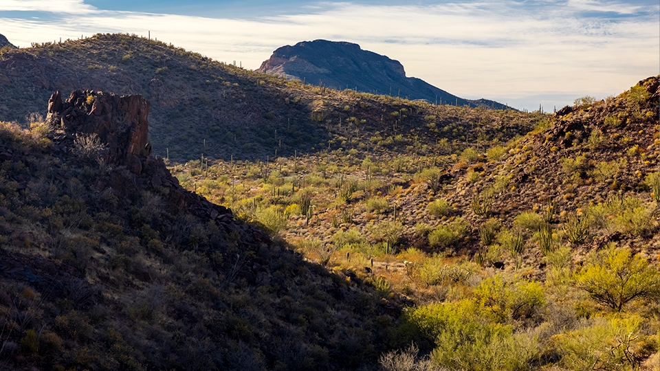
Continuing on, the trail winds through a valley of lush vegetation, which, along with the many cactus species, includes agaves, mesquites, ocotillos and paloverdes. And in the spring, if the weather cooperates, the canyon will vibrate with the color of desert wildflowers. Mexican goldpoppies, lupines, globemallows, brittlebush and owl’s-clover are the most likely.
About a half-hour in, the trail shifts from gentle undulation to a steady climb. And it starts to wind even more — if you could pick up this trail at both ends and pull it tight, like a string, it would be about half as long. The switchbacks eventually lead to a saddle that marks the beginning of the Bull Pasture Trail. At this point, you have two options: You can either continue north on the Estes Canyon Trail, or take a deep breath, head south and make the climb to Bull Pasture. The short spur is a workout — it ascends 500 feet in a half-mile — but it’s something you should do.
As you work your way up, you’ll pass an opening that offers a southward look at Mexico and the surrounding wilderness — about 95 percent of the monument (312,600 acres) has been given the ultimate protection, making it the third-largest wilderness area in Arizona. Then, after an hour of overall hiking, the trail arrives at Bull Pasture, which early ranchers used for their cattle. You won’t see any cows today — the last of them were removed from the park in 1972 — but the views are nearly 360 degrees and include a great look at Mount Ajo, the highest point (4,808 feet) in the monument.
Best of all, there’s a good chance you’ll have the pasture to yourself. This trail doesn’t get a lot of traffic. Enjoy the solitude, and then backtrack to the Estes Canyon Trail. From there, the rest of the descent goes quickly as you pass through a pristine example of the Sonoran Desert ecosystem, and the only biosphere reserve in the state.
Length: 3.75 miles round-trip (including Bull Pasture)
Difficulty: Moderate
Elevation: 2,303 to 3,188 feet
Trailhead GPS: N 32˚00.961', W 112˚42.715'
Directions: From the visitors center at Organ Pipe Cactus National Monument, go north on Ajo Mountain Drive for 11 miles to the trailhead.
Special Consideration: National park fees apply.
Vehicle Requirements: A high-clearance vehicle, such as an SUV or truck, is recommended, but the road is passable in a standard sedan in good weather.
Dogs Allowed: No
Horses Allowed: No
USGS Map: Mount Ajo
Information: Organ Pipe Cactus National Monument, 520-387-6849 or nps.gov/orpi