
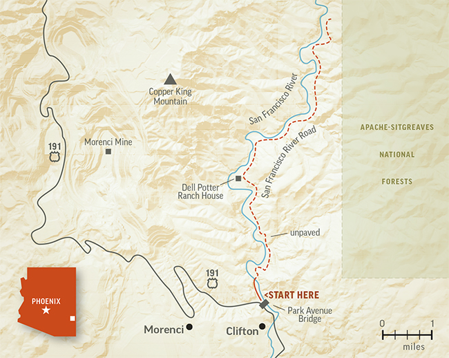
At Arizona Highways, we want to give you your money’s worth — which is why, for a scenic drive to become a Scenic Drive, it has to have plenty of scenery. That often means the drive needs to be a certain length. San Francisco River Road, which parallels its namesake waterway, is an exception: There’s so much beauty along it that this short trip is more than worth the journey.
The scenery begins before you even leave the town of Clifton, at the historic Park Avenue Bridge, which dates to the 1910s and once was the only bridge linking both sides of the San Francisco River. From the south end of the bridge, head northwest on Frisco Avenue, which passes an American Legion post, a playground and an RV park before turning into San Francisco River Road at another bridge over the river.
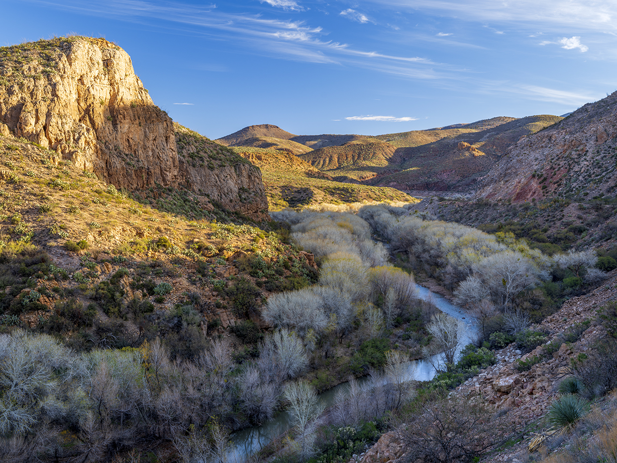
The pavement ends at that bridge, but what remains is a smooth, well-maintained gravel road suitable for just about any vehicle in good weather. It offers excellent views of the cottonwoods and other riparian plants that dominate the river channel. Because that vegetation is thriving, glimpses of the river itself are fleeting, but the perennial waterway, a tributary of the upper Gila River, makes an impression when you see it flowing through this desert landscape.
At Mile 1.5, you’ll cross a wash, then pass tall cottonwoods on the left and a hillside of ocotillos on the right. The road then climbs steeply, and as you crest that hill, you’ll get a view of Copper King Mountain to the northwest; behind this peak is the Morenci Mine, one of the most productive copper mines in North America.
The views here also include the river channel, now far below the road. There, you’ll spot the Dell Potter Ranch House, a Mission Revival-style home built in 1901 and listed on the National Register of Historic Places in 1977; today, it’s a private residence. You’ll also see numerous prickly pear cactuses clinging to the cliffs along the road.
Next comes a stretch of tall, reddish-brown cliffs on the right; at Mile 3.9, the cliffs part to reveal a steep canyon full of rock spires. There are more of those a couple of miles ahead, even closer to the roadway; you’ll notice that some of them are sprouting clusters of prickly pears from their tips.
You’ll also get more views, on the left, of the San Francisco, which holds a unique place in Arizona history. In 1825, Kentucky trapper James O. Pattie and a companion are said to have ascended the river — which, at the time, was part of Mexico — and trapped 250 beavers in two weeks. The expedition, which may or may not have been completely legal, is thought to have made the pair the first American citizens to enter present-day Arizona.
The official end of this drive is at Mile 6.7, at a vault toilet that marks the top of a maze of roads leading down to the river. These roads, along with the remaining 1-mile stretch of the main road, are rough and rocky, so if you don’t have a high-clearance vehicle, you’re better off hiking down to the river. There, you’ll find a quiet, peaceful river lined with tall cottonwoods and shaded by imposing cliffs. You might find yourself wanting to stay awhile. After all, you didn’t have to spend much time in the car to get there.
Tour Guide
Note: Mileages are approximate.
Length: 6.7 miles one way (from Clifton)
Directions: From the Park Avenue Bridge in Clifton, go northwest on Frisco Avenue, which turns into San Francisco River Road, for 6.7 miles to the stopping point.
Vehicle Requirements: None in good weather.
Warning: Back-road travel can be hazardous, so be aware of weather and road conditions. Carry plenty of water. Don’t travel alone, and let someone know where you are going and when you plan to return.
Information: Town of Clifton, 928-865-4146 or cliftonaz.com
Travelers in Arizona can visit www.az511.gov or dial 511 to get information on road closures, construction, delays, weather and more.