
Santa Cruz County, in Southern Arizona, has no shortage of natural beauty, but there’s plenty of human history, too — including several ghost towns. This easy drive, which starts in the small town of Patagonia, will take you to two of them — one you can see from your car, and one that requires a bit of a hike.
From State Route 82 in Patagonia, go south on Taylor Avenue, then turn left onto McKeown Avenue — which later becomes Harshaw Road (Forest Road 58), the main route for this drive. After passing through the outskirts of town, you’ll be in a rolling landscape of mesquites and ocotillos. At Mile 2.7, you’ll reach a crossing for the Arizona Trail and enter the Coronado National Forest before traversing a narrow bridge over Harshaw Creek.
From here, Harshaw Road descends into an area of oaks and other larger trees, then climbs back into the hills on the northern fringes of the Patagonia Mountains. At a “T” intersection at
Mile 5.9, turn right to stay on paved Harshaw Road, which now is Forest Road 49. The pavement gives way to a mostly smooth dirt route and passes some large cottonwoods before Mile 7.8, where you’ll reach a “Y” intersection at the site of the former town of Harshaw.
This silver mining boomtown grew to an estimated 2,000 residents in the early 1880s, and it reportedly boasted several saloons and breweries, two or three hotels, numerous shops and its own newspaper. But a violent storm, a fire and a drop in ore quality led to a quick decline, and while nearby mines brought some life back to town in the 1930s and ’40s, Harshaw never regained its former glory.
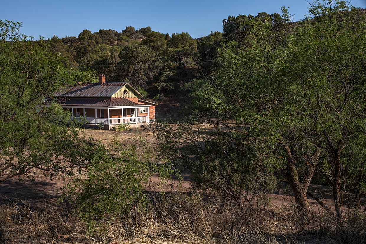
Today, the remnants of Harshaw include a decaying adobe residence just east of the “Y” intersection and a small cemetery on the west side of FR 49. But you can bear left at the “Y” and continue a quarter-mile to reach the best relic: a house that once belonged to mine owner James Finley. Listed on the National Register of Historic Places since 1974, the house is on private property, but seeing it from the road is allowed if visitors stay on the road, respect “Private Property” signs and don’t venture closer to the house or any farther down the road.
Return to FR 49 and turn left to continue south. You’ll pass a few large Arizona sycamores before entering a landscape of alligator junipers, scrub oaks and a few cottonwoods, along with
occasional yuccas and prickly pear cactuses. The road then narrows and gets a bit rougher and more rutted before you reach the Santo Nino Ranch. Here, turn left onto Apache Road (Forest Road 214) and continue less than a quarter-mile to the first side road on the left.
This road isn’t suitable for vehicles, so park along Apache Road and hike up the side road a quarter-mile or so to Mowry — named for Sylvester Mowry, a colorful character who purchased the Mowry Mine in 1860. The mine, one of Arizona’s oldest mining camps, produced a reported $1.5 million in silver but was abandoned by the 1870s.
The hike up the hill includes a few foundations and crumbling adobe walls, along with a large slag pile. At the top of the hill is the jewel of the site: a large stone building, its four walls still intact. Wander the hillside to find more relics and take in the view of the surrounding Coronado National Forest. It’s lovely. Like most of the views in Santa Cruz County.
tour guide
Note: Mileages are approximate.
Length: 13.3 miles one way
Directions: From the intersection of State Route 82 and Taylor Avenue in Patagonia, go south on Taylor Avenue for 0.1 miles to McKeown Avenue. Turn left onto McKeown Avenue, which later becomes Harshaw Road (Forest Road 58), and continue 5.8 miles to a “T” intersection. Turn right to stay on Harshaw Road (now Forest Road 49) and continue 1.9 miles to a “Y” intersection. Bear left and continue 0.3 miles to James Finley’s house in Harshaw. Backtrack 0.3 miles to Harshaw Road, turn left and continue 4.7 miles to Apache Road (Forest Road 214). Turn left onto Apache Road and continue 0.2 miles to the side road, on the left, that leads to Mowry.
Vehicle requirements: A high-clearance vehicle, such as an SUV or truck, is recommended, but four-wheel-drive is not necessary in good weather. Don’t attempt the drive after recent heavy rain or if rain is in the forecast.
Warning: Back-road travel can be hazardous, so be aware of weather and road conditions. Carry plenty of water. Don’t travel alone, and let someone know where you are going and when you plan to return.
Information: Sierra Vista Ranger District, 520-378-0311 or fs.usda.gov/coronado