
Don’t let the name fool you. It’s deceiving. There is a mountain, and it’s the focus of the hike, but what happens between the trailhead and the top is very different from what you’ll experience on Humphreys Peak, Mount Baldy or Granite Mountain. With those, and with most other mountain hikes, there’s an understanding that you’ll huff and puff on the way up — a gradual ascent to the summit — and then coast back down. That’s not what happens on the West Spruce Mountain Trail. Like the lines on an echocardiogram, the slope of this route is up and down. Up and down, up and down, up and down. The deceit is in the numbers.
On paper, the elevation gain from the trailhead to the top is only 344 feet. That’s not so bad, you’ll think. However, with all the ascending and descending, you’ll actually climb more than a thousand feet on the way up. Then, on the way “down,” you’ll get to do it all over again.
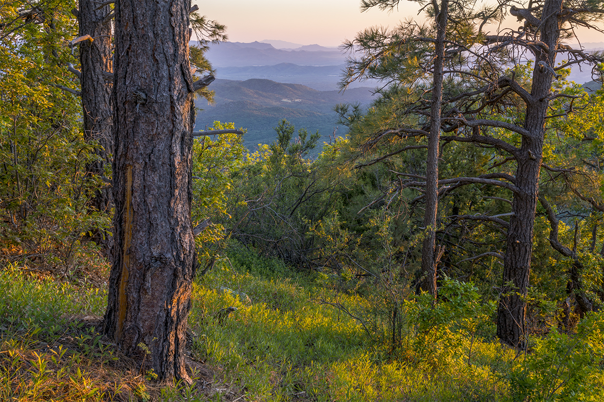
From the trailhead, the route begins with a slight climb on a rocky track. Almost immediately, you’ll start seeing alligator junipers, which punctuate the landscape with their ancient wisdom. At first, they’re small, but they get bigger as you go. And as you go, you’ll follow a well-maintained barbed-wire fence that separates hikers from the Copper Basin Wash, a deep ravine to the south that presses against the Sierra Prieta.
After about 10 minutes, the first giant juniper shows up. Like most old gators, it’s a gnarly specimen with multiple trunks fused together. Because of those many trunks and the tree’s ability to produce more than one tree ring annually, it’s hard to know exactly how old an alligator juniper is. The oldest confirmed gator is more than 500 years old, but it’s possible there are some that are more than a thousand. Whatever its age, this big fella is a beauty. And it stands out even more because the forest along this stretch has been thinned to help mitigate wildfire.
Continuing on, you’ll see granite boulders in the distance as you make your way to a small saddle that’s governed by another giant gator. You’ll also see a log-rail barrier, the first of several on the route. They’re there to keep mountain bikers on the trail. Just beyond the rail, you’ll make the first of several downhill runs. A few minutes later, you’ll climb out of a gully, then descend again. As that’s happening, the trail crosses into a canopied woodland where ponderosa pines offer some shade. To this point, the trail has been mostly exposed, which is why it’s a good idea to be at the trailhead early, before the sun gets too hot.
A half-hour in, the trail intersects the Williams Peak Trail (No. 738). However, about 20 yards before that, the West Spruce Mountain Trail veers left onto what looks like a little-used crosscut trail. There’s no marker at either intersection, but if you veer left at one or the other, you’ll see a trail sign (No. 264) up ahead. This is the only tricky part. The rest of the route is a straight shot to the northwest.
Along the way, you’ll pass through groves of young ponderosas and thickets of oaks. You’ll get a distant look at Skull Valley to the west. You’ll hear birds. And you’ll feel the breeze. The wind whistles across the Sierra Prieta, a 14-mile-long mountain range the old-timers call the “Sierry Petes” — the name comes from an old cowboy poem by Prescott native Gail Gardner.
After an hour of ups and downs, the trail offers its first set of switchbacks, which lead to an intersection with Trail No. 300 — the route to Porter Mountain (7,057 feet). From there, the hike continues its climb until … once again, it drops down, climbs up and passes another giant gator. The trail ends at an intersection with Forest Road 47B. And that’s another deceitful twist: The hike never actually makes it to the summit. The top is a few hundred yards to the southwest. So, if you want to bag this peak (7,169 feet), you’ll have to blaze a trail through the woods, but that can be dangerous. Instead, conserve your energy. There’s a lot of uphill on the downhill to the trailhead.
ADDITIONAL READING: For more hikes, pick up a copy of Arizona Highways Hiking Guide, which features 52 of the state's best trails — one for each weekend of the year, sorted by seasons. To order a copy, visit www.shoparizonahighways.com/hikingguide.
Trail Guide
Length: 7 miles round-trip
Difficulty: Moderate
Elevation: 6,718 to 7,062 feet
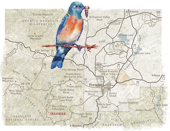
Trailhead GPS: N 34˚30.633', W 112˚33.446'
Directions: From Courthouse Square in downtown Prescott, go west on Gurley Street, which turns into to Thumb Butte Road, for 5.1 miles to Thumb Butte Loop Road. Turn left onto Thumb Butte Loop Road (the pavement ends) and continue 3.2 miles to the small trailhead on the right.
Vehicle Requirements: A high-clearance vehicle, such as an SUV or truck, is recommended.
Dogs Allowed: Yes
Horses Allowed: Yes
USGS Map: Iron Springs
Information: Bradshaw Ranger District, 928-443-8000 or fs.usda.gov/prescott
LEAVE-NO-TRACE PRINCIPLES:
• Plan ahead and be prepared.
• Travel and camp on durable surfaces.
• Dispose of waste properly and pack out all of your trash.
• Leave what you find.
• Respect wildlife.
• Minimize campfire impact.
• Be considerate of others.