
Tonto National Monument
Also a cultural melting pot, the site now known as Tonto National Monument was one of the most densely occupied areas for the Salado people, who lived in the Tonto Basin region between A.D. 1250 and 1450. The Salado culture came about when members of the Ancestral Puebloan, Ancestral Sonoran Desert and Mogollon cultures moved into the Tonto Basin.
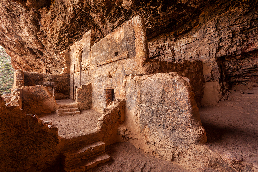
Tonto National Monument protects two Salado dwellings that are believed to have been built around A.D. 1300. While both dwellings are inside caves, the Lower Cliff Dwelling is in a smaller area and has only 20 rooms. The Upper Cliff Dwelling, on the other hand, has 40 rooms and overlooks the Tonto Basin. These days, the upper dwelling is accessible only through guided tours.
Both dwellings were built by the Salado people to protect them from the elements. All of the doorways are small — they were constructed that way to make it easier to regulate temperatures.
The climate in the Tonto Basin was favorable for the settlers to cultivate corn, beans and squash, and the geography allowed them to hunt for small game. But the climate shifted around A.D. 1350, making it harder to sustain crops in an area that often suffered from severe drought or flooding. By the late 1300s, the resources were depleted and the settlers had no choice but to move out of the Tonto Basin and merge with other nearby tribes.
Things to Do
- Guided tour: Tours to the Upper Cliff Dwelling are offered from November through April. Reservations are required.
- Lower Cliff Dwelling Trail: A 1-mile (round-trip) trail leads to the Lower Cliff Dwelling. The self-guided trail is open daily.
Canyon de Chelly National Monument
At press time, Canyon de Chelly National Monument was closed to visitors due to COVID-19 restrictions.
While it’s on what now is the Navajo Nation, Canyon de Chelly’s tribal roots reach back much further. According to Ravis Henry, a park ranger and resident at the canyon, archaeological records indicate that Canyon de Chelly has been continuously occupied for at least 5,000 years. The first group of people to live there, archaic hunters and gatherers, were in the area until about 200 B.C. Around that time, members of the Basketmaker II culture moved into the region and became the first to use the land for farming. “They’re the people who brought in the corn and other crops to cultivate across the canyon floor,” Henry says.
This group was also the first to build permanent structures, known as pit houses, in the canyon. They used whatever material they could find, including brush, shrubs and dirt, to create these structures. While the pit houses didn’t stand the test of time, there’s still evidence of their existence on the canyon floor, where foundations can be seen today.
Around A.D. 700, the Basketmaker II people gave way to the Ancestral Puebloans, who built many of the still-standing stone and clay structures within the canyon, such as White House Ruins and Mummy Cave Ruins. Next, the Hopis migrated into the canyon to use the land for agricultural and ceremonial purposes. Perhaps their biggest contribution in the region was introducing peach trees, which continue to be a fruitful crop for canyon dwellers. The Hopis stayed in the area from roughly 1300 to 1600, when the Navajo people transitioned into the canyon.
After the Navajos’ military-imposed exile in New Mexico ended in the late 1860s, members of the tribe returned to the canyon, and they’ve been there ever since. Navajos continue to occupy areas within the monument, including the canyon floor and rim. Part of what makes that possible is that Canyon de Chelly is on Navajo trust land, not owned by the federal government, thanks to a collaboration between the Navajo Nation, the Bureau of Indian Affairs and the National Park Service. “The Indigenous people at many other parks are not allowed to occupy within the boundaries,” Henry says. “The unique setup allows Navajo families to still live within the park.”
Today, there are about 40 large families still living at Canyon de Chelly, and while many have adapted to modern agricultural techniques, they still lack access to amenities such as running water and electricity, and most, both on the canyon floor and along the rim, are living off the grid.
“We’re not really that different from modern society,” Henry says. “But our identity and culture are still very strong.”
Things to Do
- Canyon tours: Private tour companies offer trips into the canyon via vehicles, horseback rides or hikes. Private vehicles are not allowed in the canyon.
- White House Ruins Trail: A moderately strenuous 1.25-mile (one way) hike takes you to the ancient dwelling. This trail does not require a guide.
- North Rim and South Rim drives: Each drive provides access to several viewpoints along the rim, including overlooks of Spider Rock and Canyon del Muerto.
Navajo National Monument
At press time, Navajo National Monument was closed to visitors due to COVID-19 restrictions.
Navajo National Monument, about 60 miles northwest of Canyon de Chelly, follows a similar timeline of tribal occupation — transitioning from hunters and gatherers to Basketmakers before being inhabited by the Ancestral Puebloans. Like at Canyon de Chelly, agriculture played a key role. Roughly 2,000 years ago, the Puebloans started farming corn and other crops in the region to serve as their main source of food. During this time, they also learned how to create permanent structures, which are what the monument protects today: Keet Seel, Betatakin and Inscription House, all believed to have been built in the 13th century. They were built into natural alcoves to maintain structural integrity and protect inhabitants from the elements.
While the Puebloans were able to use the canyon beds for farming, an eventual prolonged drought is believed to have caused them to leave the area around 1300. In 1909, the area was protected by the Park Service to preserve what’s left of the cliff dwellings and the history of the people who once occupied the region.
Things to Do
- Self-guided trails: Three short trails (Sandal, Aspen and Canyon View) near the visitors center offer the opportunity to explore the area on your own from sunrise to sunset.
- Cliff dwelling tours: Guided tours to Betatakin and Keet Seel are available by making reservations through the Park Service. Keet Seel can also be visited, with a permit, by day hikers and those who stay overnight in the campground near Keet Seel. (Inscription House is not open to the public.)
- Camping: Two free campgrounds are open to visitors on a first-come, first-served basis..
Wupatki National Monument
Considered a melting pot of tribal cultures, what now is Wupatki National Monument was home to a diverse group of people from the time it was inhabited in A.D. 500 until it was seemingly abandoned around A.D. 1250. Part of what attracted a large population to the site may have been the eruption of nearby Sunset Crater around A.D. 1040. The volcanic ash made the ground fertile for growing crops, such as squash and corn.
Wupatki (“tall house”) Pueblo is one of the largest in the area, and its more than 100 rooms are believed to have housed hundreds, if not thousands, of people over the years. It’s constructed of sandstone, which gives it a distinctive red hue. In addition to the largest pueblo, several smaller pueblos in the 35,000-acre protected area have stood the test of time. Wukoki, Nalakihu, Citadel, Lomaki and Box Canyon pueblos are the ones people can visit and explore today.
As many as 13 tribes are believed to be associated with Wupatki, all having passed down stories of their connections to the site from generation to generation.
Things to Do
- Self-guided trails: There are several trails you can take to explore the different pueblos.
- Guided hikes: Rangers will guide you on trails to see parts of the protected area that are not accessible on your own.
Walnut Canyon National Monument
The impressive cliff dwellings at Walnut Canyon reveal crucial information about the Sinagua people, Ancestral Puebloan descendants who inhabited the area from approximately A.D. 600 to 1400. The name Sinagua, meaning “without water,” comes from the old Spanish name for the area: Sierra de Sin Agua, meaning “mountains without water.”
When the Sinaguans migrated into the area, they used dry-farming techniques to harvest corn, squash and beans in the arid climate. While Walnut Creek served as a source of water for parts of the year, it was not a reliable source for irrigating crops, so the settlers took to collecting rainwater and creating small dams to support their water supply.
The Sinaguans first made their homes as pit houses along the rim of the 20-mile-long canyon, but as more people arrived, they had to expand their building skills to be able to live along the sandstone and limestone walls of the beautiful woodland canyon.
Present-day visitors can walk among 25 of the Sinaguan cliff dwellings and marvel at their architectural techniques, which were well ahead of their time. According to the Park Service, Sinaguan women are credited with constructing the dwellings, using limestone rocks cemented with clay, and reinforcing doorways with wooden beams. In an attempt to make the most of daylight hours, the dwellings are located primarily in the southern and eastern portions of the canyon.
The Sinaguans lived in Walnut Canyon for about 125 years before moving to nearby villages around A.D. 1250. They originally left behind more than 80 dwellings with three or four rooms each, but pothunters in the 1880s dynamited some of the area, destroying many of the dwellings.
Things to Do
- Hiking trails: Two self-guided trails will take you to the cliff dwellings.
Montezuma Castle National Monument
The area surrounding Montezuma Castle National Monument is believed to have been inhabited around A.D. 1100. Some of the occupants were Sinaguans who had moved from the Walnut Canyon area in favor of the natural resources available in the Verde Valley.
“We have great major waterways, giving this lush green area its name,” says Paul Santellan, the lead interpretive park ranger at Montezuma Castle. “It attracts life. Not only animal life, but people, too.”
The Sinaguans used their architectural skills to build the eponymous cliff dwelling at Montezuma. The high location protected them from flooding caused by nearby Beaver Creek, and the south-facing orientation kept them warm in the winter and cool in the summer. While referred to as one “castle,” the dwelling is made up of 20 rooms, which were occupied by several families.
According to Santellan, the Sinagua people continued living at Montezuma Castle until A.D. 1300. At that time, the land could no longer support the population growth and people started migrating. Some followed trade routes to present-day Mexico, while others headed north, toward what now is Colorado.
“They were a thriving community that helped each other succeed,” Santellan says. “There was no turmoil or war that drove people out.”
Things to Do
- Self-guided trail: This one-third-mile loop allows you to gaze up at Montezuma Castle and get a view of the river.
- Ranger talks: Daily presentations cover a variety of topics related to the history and geography of the area.
Tuzigoot National Monument
Another agriculturally appealing place within the Verde Valley was where Tuzigoot stands now. The Sinagua people were drawn there because the marshy area was ideal for crops, Santellan says. Much like at Montezuma Castle, the Sinaguans started building multi-room pueblos around A.D. 1100. The location, atop a limestone ridge, not only protected them from the floodplain of the Verde River but also gave them clear views of the surrounding area.
The artifacts left behind by the Sinaguans at Tuzigoot shed light on their often-overlooked pottery-making skills. According to Santellan, large water and food storage containers (called ollas) provide insight on how carefully Tuzigoot’s residents considered their systems of preserving perishable items.
Unlike the dwellings at Montezuma and Walnut Canyon, the Tuzigoot pueblo was not built into cliffs, which made it vulnerable to weathering. By the 1900s, many of the walls had collapsed, encasing artifacts. An archaeological excavation led by two University of Arizona students in the mid-1930s helped reveal some of those buried artifacts, as well as the original architecture of the pueblo.
Today, the pueblo is open for visitors to explore and admire the architectural techniques of the Sinagua people.
Things to Do
- Museum: Learn about the excavation of the pueblo and which artifacts were found inside.
- Self-guided trail: Take a short walk to the pueblo and walk through the rooms constructed by the Sinagua residents.
Casa Grande Ruins National Monument
Casa Grande, or “great house,” is believed to have been built around A.D. 1350 by the Ancestral Sonoran Desert people. To this day, it’s unclear why these desert dwellers constructed such a large compound, which required extensive amounts of planning and building materials. On top of developing Casa Grande, the settlers worked on perfecting complex irrigation systems and extending trade connections.
While the ruins left today encompass the entire Casa Grande compound, the main attraction is the four-story “great house.”
Researchers believe that by A.D. 1450, Casa Grande’s inhabitants had abandoned the area. Anything from disease and famine to population growth could have been the reason for their migration. There’s no evidence of these people having a written language, which is why many of the historical accounts of the area weren’t written until the 17th century, when Spanish explorers discovered the ruins.
Things to Do
- Self-guided tour: You can take a walk around the “great house” and learn about the structure.
- Guided tours: One-hour guided tours, scheduled in advance, are offered from November through April during non-COVID