
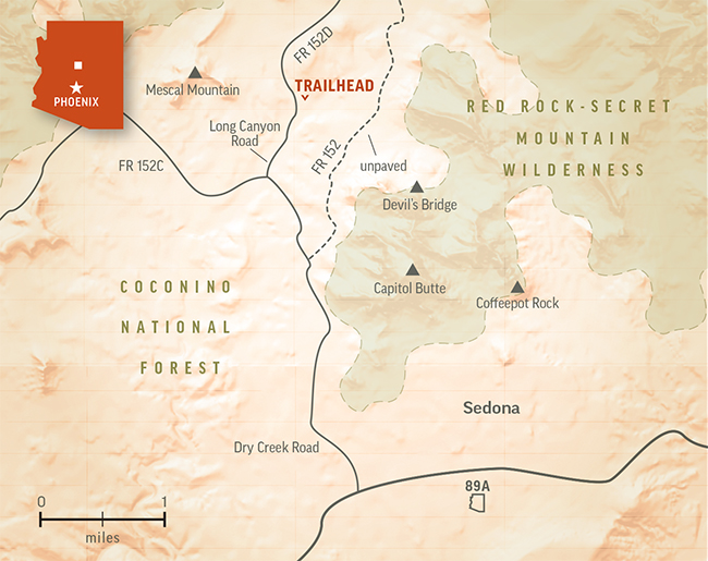
There’s nothing inherently sinister about the Devil’s Bridge Trail. It’s the drive to the trailhead that’s out to get anyone who dares to cross the threshold. Sharp rocks, big boulders, deep ruts, steep drop-offs ... Forest Road 152 passes through the seven gates of hell. It’s rugged. And threatening. In fact, unless your “other car” is a 25-ton infantry fighting vehicle, you’ll have to consider the other options. And there are some. One is to park at the Dry Creek Trailhead and hike about a mile on FR 152 to the Devil’s Bridge Trailhead. (You could bike it, too, if you have a mountain bike.) Another option is to park at the Mescal Trailhead, which is located along the shoulder of Long Canyon Road.
Choosing that option, the hike heads east from the narrow parking area on a red-dirt track. The trees are piñon pines and junipers about 20 feet tall. You’ll see manzanitas and prickly pear cactuses, too. Then, after about a minute, you’ll come to a wash. Most of the time, it’s dry. However, if there is water — usually in the spring or during the summer monsoon — it’ll slow you down. Like a moat. Once you get across, you’ll continue meandering through the trees and eventually drop into another small wash. The trail follows the bottom of the streambed, which is rocky, but not technical. Then, after about 15 minutes of overall hiking, it intersects the Chuckwagon Trail.
Veer left onto the Chuckwagon and continue doing what you’ve been doing. Along the way, you might see Steller’s jays — a swatch of bright blue against a palette of earth tones. If you get an early start, you might see hot-air balloons, too. Even more impressive are the views of the surrounding red rocks, including Mescal Mountain to the west and Courthouse Butte to the south.
Ten minutes past the intersection, you’ll arrive at the Devil’s Bridge Trail. Turn right onto the DBT and continue a few minutes more to FR 152. Just across the road is the official trailhead for this hike, which leads into a wide valley on the north side of Capitol Butte.
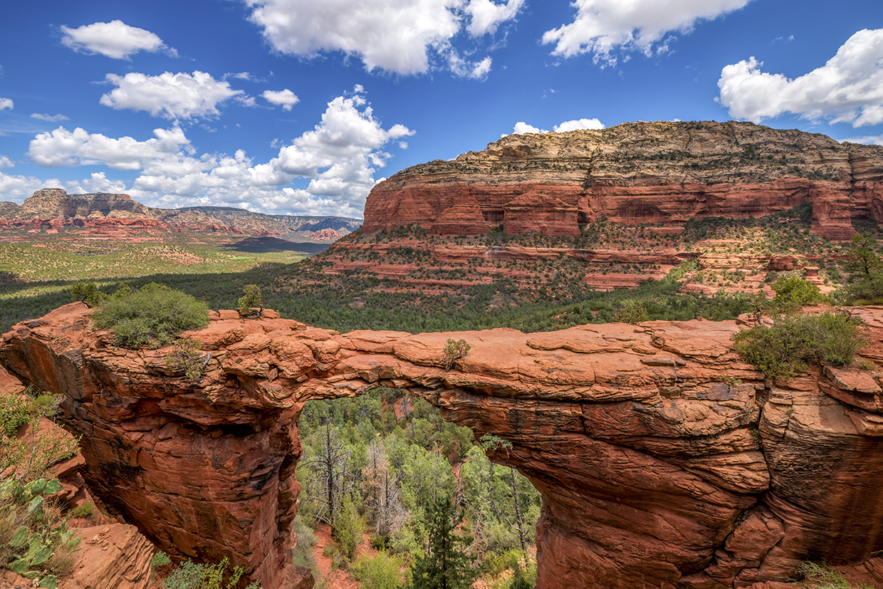
The DBT is a short, easy trail that begins as an old jeep road. It’s all uphill from this point forward, but it’s not enough to slow you down. About 10 minutes in, you’ll come to a cairn on the left that marks a faint trail. Your instincts will say, No, but it’s a worthwhile detour that winds for 30 or 40 yards to a great view of Devil’s Bridge, the centerpiece of the hike.
Despite its name, the rock formation is technically an arch, not a bridge — it was created by wind and weather erosion, not by flowing water. Nevertheless, it’s an impressive landmark that ranks as the largest natural sandstone arch in the area. Late afternoon is the best time to make a photo from this vantage point.
Back on the main trail, you’ll quickly cross into the Red Rock-Secret Mountain Wilderness, which is home to elk, black bears, mountain lions, ringtails, badgers and bobcats. It’s unlikely you’ll see any of those on this route, but the social responsibilities of hiking in a wilderness area — specifically, adhering to the principles of Leave No Trace (see below) — remain the same.
Continuing up, you’ll pass through a wash and a thicket of trees, after which the trail veers left and arrives at a steep set of natural rock steps. It shouldn’t take more than two minutes to make the climb. At the top, the trail levels off and heads east.
Although it’s always a good idea to watch your step, you’ll want to start looking to your left, too. Almost immediately, you’ll see the bridge in that direction. To get there, keep walking and follow the trail as it continues through some trees and down to the rim. The bridge will be to your left. Proceed with caution and enjoy the views, which, as you’ll see, are antithetical to what you’d expect at a place called Devil’s Bridge.
Trail Guide
Length: 3.8 miles round-trip (from Mescal Trailhead)
Difficulty: Easy
Elevation: 4,466 to 4,916 feet
Trailhead GPS: N 34˚54.107', W 111˚49.605'
Directions: From the roundabout intersection of state routes 179 and 89A in Sedona, go southwest on SR 89A for 3.1 miles to Dry Creek Road. Turn right onto Dry Creek Road and continue 2.7 miles to Long Canyon Road. Turn right onto Long Canyon Road and continue 0.1 miles to the Mescal Trailhead.
Special Consideration: A $5 day pass is required.
Vehicle Requirements: None
Dogs Allowed: Yes
Horses Allowed: Yes
USGS Map: Wilson Mountain
Information: Red Rock Ranger District, 928-203-2900 or fs.usda.gov/coconino