
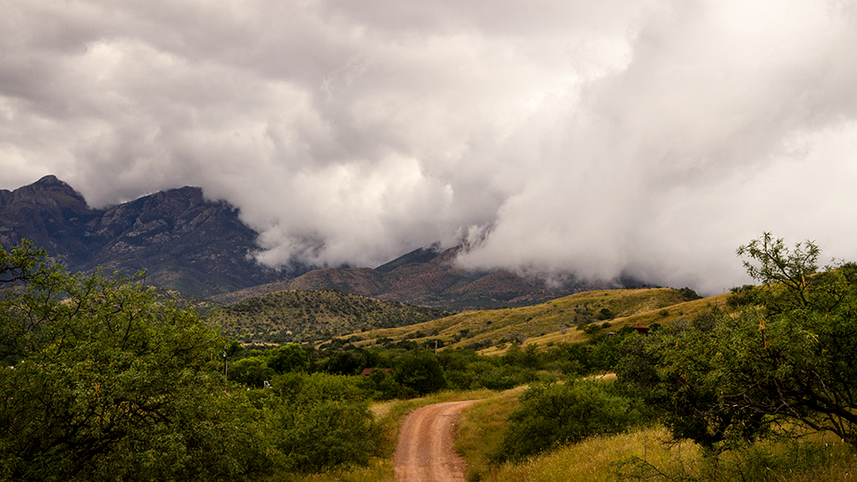
Santa Rita Mountains, Sonoita
Gardner? Or Gardiner? It depends on whom you ask. According to the book Arizona Place Names, Gardner Canyon — which is northwest of Sonoita, on the east side of the Santa Rita Mountains — was named for the Gardiner family, who built a homestead in the canyon in the 1870s. But other sources, including the ranch the homestead became, say the family’s name was Gardner all along. Regardless, the spelling today is Gardner Canyon, which you can explore via a short, rugged forest road that features creek crossings, gorgeous grasslands and a little local history.
From State Route 83 a few miles north of Sonoita, head west on Gardner Canyon Road (Forest Road 92). Mesquites and alligator junipers line the road early on as you approach a turnoff, on the right, for Kentucky Camp, an access point for Passage 5 of the Arizona Trail. Stay straight, though, to remain on FR 92.
Next, you’ll pass several side roads that lead to primitive camping areas. The Santa Ritas loom straight ahead, and at Mile 3.3, the road begins to climb into the mountains as it passes another campsite. About a half-mile later, on the right, is a hillside covered in some of the most pristine tall grasses you’ll see in Arizona. It’s one of the many picturesque grasslands you’ll encounter along the road.
About 4.5 miles in, you’ll reach a “Y” intersection. Stay to the right, and a mile later, you’ll come to Apache Springs Ranch, the former Gardner (or was it Gardiner?) homestead. Here, Tom Gardner and his wife, Gertrude, raised 12 children, many of whom died of diseases in childhood — and one of whom, according to the ranch, was killed by a lightning strike while her mother held her in her arms. Today, the ranch hosts overnight guests and wellness retreats, and its accommodations include Tom Gardner’s original cabin, which has been extensively remodeled and expanded.
A half-mile past the ranch, the road gets much rockier as it drops to the canyon floor, then climbs again. At a subsequent intersection, stay on FR 92 by following the signs for the Cave Canyon Trail. Around Mile 7.5, ponderosa pines begin to replace the junipers and other small trees along the road, and a mile after that, you’ll bump across another creek. From there, it’s a quarter-mile to the end of the road at the Cave Canyon Trailhead.
If you’re in the mood for a hike, this relatively steep trail offers views of the Mustang and Whetstone mountains to the east and the Huachuca Mountains to the southeast, and from the route’s endpoint, Florida Saddle, you can explore the Santa Ritas via an extensive network of trails. If you’d rather not break a sweat, the area around the trailhead — shaded by junipers, pines and tall Arizona sycamores — makes a lovely picnic spot. No matter how you spell it.
Note: Mileages are approximate.
Length: 8.7 miles one way (from State Route 83)
Directions: From Sonoita, go north on State Route 83 for 4 miles to Gardner Canyon Road (Forest Road 92). Turn left (west) onto Gardner Canyon Road and continue 8.7 miles to the Cave Canyon Trailhead.
Vehicle requirements: A high-clearance, four-wheel-drive vehicle is required.
Warning: Back-road travel can be hazardous, so be aware of weather and road conditions. Carry plenty of water. Don’t travel alone, and let someone know where you are going and when you plan to return.
Information: Nogales Ranger District, 520-281-2296 or www.fs.usda.gov/coronado; Apache Springs Ranch,
520-455-9263 or www.apachespringsranch.com