
Black Hills, Eastern Arizona
Cruising among the Black Hills near Safford, it’s easy to get carried away in an imaginary game of cowboys and Indians. Patches of prickly pear cactuses and fields of native grasses cover the talus slopes, which were crafted by volcanic activity more than 20 million years ago. The foliage would make for some seriously great cover should a battle break out — or, better yet, a pretty prickly corner into which the enemy could be backed. Either way, it’s easy to see why Geronimo wandered these hills during raids into Mexico and back.
The 21-mile drive begins at its southern point, off of U.S. Route 191, approximately 20 miles east of Safford. You’ll turn left onto the Black Hills Back Country Byway, a gravel road that’s maintained by Graham and Greenlee counties. Although a four-wheel-drive vehicle isn’t necessary — unless you plan to explore one of the numerous side roads along the way — a high-clearance vehicle is recommended.
Prison laborers built the byway between 1914 and 1920, during which a few managed to escape. Most, however, behaved. Just as the hillsides are great for a Wild West game of hide-and-seek, they’re also foreboding. If you venture outside the car for a closer look, be sure to keep your eyes peeled for rattlesnakes and other desert critters.
Several interpretive areas pepper the route, and there are other potential stops along the way. The first comes approximately 3 miles into the drive, where the road crests above the Twin C Ranch. There, you can take a side trip to the Black Hills Rockhound Area in search of fire agate or continue past an abandoned mine. Just down the road, a cinder pit looms red and dusty against the onyx hills. In the 1950s, miners pulled pumice from the pit and trucked it to Safford, where it was converted into cinder blocks.
This is a good spot to look up. On a crisp, clear day, a swath of mountain-studded desert paints the horizon, and the Dos Cabezas Mountains rise a scant 50 miles away. From there, the road climbs steadily into the hills as chollas and bursts of yuccas punctuate the abundant prickly pears. The road reaches its highest point near the 12-mile mark, then descends in a series of twists and turns.
The remnants of the labor camp, where the prisoners rested each evening, are a quick walk from the roadside between Mileposts 16 and 17. The old structures are nothing special — just block and rebar — but they do speak to the ruggedness of the terrain. Life in the Black Hills at the beginning of the 20th century couldn’t have been easy. Mining was big here during Arizona’s boom days, when cotton and copper were king in this neck of the woods, and it still is today — the Freeport-McMoRan open-pit copper mine in Morenci is a fitting reminder of that.
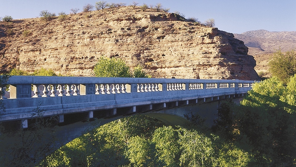
The road winds back to U.S. 191 after traversing the Old Safford Bridge, which crosses the Gila River. The bridge, constructed in 1918, doesn’t look a day over 32 — partly because it was restored several years ago. Just below the bridge is a popular place to launch rafts and kayaks to float the 23 miles of river in the Gila Box Riparian National Conservation Area. Past the bridge, the Bureau of Land Management’s Owl Creek Campground provides views of the river and riparian area below.
Note: Mileages are approximate.
Length: 21 miles one way
Directions: From Safford, go east on U.S. Route 70, which runs concurrently with U.S. Route 191, for 10 miles, until the two routes split. Turn left (north) onto U.S. 191 and continue 10 miles to the Black Hills Back Country Byway entrance (near Milepost 139). Turn left onto the byway and continue 21 miles to its northern junction with U.S. 191.
Vehicle requirements: A high-clearance vehicle is recommended. A four-wheel-drive vehicle is required to travel the roads that branch from the byway.
Information: Bureau of Land Management, Safford Field Office, 928-348-4400 or www.blm.gov/arizona
Travelers in Arizona can visit www.az511.gov or dial 511 to get information on road closures, construction, delays, weather and more.