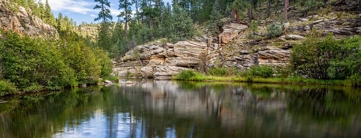
In German, kinder means “children.” It’s one of the root words in “kindergarten,” which translates to “children’s garden.” Although this hike is named for Runyon C. Kinder, a shepherd who ran sheep in the area in the late 1880s, it conjures more thoughts of children and gardens than of animal husbandry. You’ll think about kids because the trail is short and easy — it’s only three-quarters of a mile to the water. And you’ll think about gardens because of the picturesque setting at the bottom of Yeager Canyon. Kinder Crossing is lush and beautiful, an unexpected world of water and trees. “If there is magic on this planet,” Loren Eiseley said, “it is contained in water.”
There’s a definite sense of magic at the end of this trail. But it takes some effort to get to the starting line. Like a moat protecting a castle, the rugged forest road that leads to the trailhead has the effect of keeping people out. It’s a rough road compromised by mud and ruts and rocks and tree roots. And even with a high-clearance vehicle, there’s no room for error. The drive is nerve-wracking on the way down. And more so on the way out. For this one, you’ll need to know the limitations of your vehicle and your ability to drive it.
From the small parking area, the route begins as a rocky path, about 8 feet wide, that heads downhill for 175 yards to the actual trailhead, which is surrounded by Gambel oaks and ponderosa pines. Within a few minutes, you’ll see the trailhead sign and get a glimpse of where you’re going. The official trail is off to the right, through a cluster of small trees. Initially, the descent is gradual, but it’s also very rocky. Watch your step. About five minutes in, you’ll see a short spur trail that veers to the right. It leads to an overlook that offers a long view of East Clear Creek and the canyon below. Veering left from the main trail in the same spot is another lookout, one that faces north. The Horse Crossing Trail, which also leads to the creek, is off in that direction.
Just beyond the lookouts, the trail levels off a little, and the rocks are replaced by a nice bed of pine needles. It’s a brief respite, though. Within minutes, you’ll be back among the rocks that define the descent. It’s steep and rocky the rest of the way, except for a few spots where pitted steps of limestone make things a little easier.
As you make the final drop, you’ll start to hear the trickle of the creek, as well as the high-pitched, staccato calls of Steller’s jays. Then, before you know it, you’ll come to a campsite that sits on the edge of the creek, which flows from C.C. Cragin Reservoir to the southwest and eventually empties into the Little Colorado River up north — the temperature along the water drops by about 10 to 15 degrees. Most hikers call it quits at the creek. Others, however, continue for another three-quarters of a mile to Forest Road 137. If you’re so inclined, there are three things you need to know: 1) You’ll have to cross the creek, which is lined with thickets of willows, alders and poison ivy; 2) There aren’t any cairns or blazes to mark the way; and 3) The most beautiful part of the trail is the large pool at the campsite — it’s about the size of a big-league infield.
On weekends, you’ll likely see other people congregating at the water’s edge, but in the middle of the week, you might have the place all to yourself. If you do, consider yourself lucky and embrace your private time with Mother Nature. Take off your backpack, have a seat on the gravel bank and look across the water at the 80-foot rock wall that’s bursting with pines, firs and oaks. Maybe you’ll see a brown trout jump out of the placid water, or watch a wren pluck an insect off the glass. You might hear a raven fly by, and you’ll definitely hear the continuous sound of water flowing over polished rocks in the stream. It’s Mother Nature at her best on the Mogollon Rim. And it’s the payoff of this hike, whether you’re an avid hiker, a 5-year-old child or the ghost of a shepherd.
Trail guide
Length: 1.5 miles round-trip
Difficulty: Easy
Elevation: 7,007 to 6,389 feet
Trailhead GPS: N 34˚34.165', W 111˚09.258'
Directions: From Payson, go north on State Route 87 for 46.5 miles to Forest Road 95 (just past the Blue Ridge Ranger Station). Turn right onto FR 95 and continue 4.1 miles to Forest Road 95T. Turn left onto FR 95T and continue 0.6 miles to the Kinder Crossing Trail sign at the fork in the road with Forest Road 9031Y.
Vehicle Requirements: A high-clearance vehicle, such as an SUV or truck, is required on Forest Road 95T.
Dogs Allowed: Yes
Horses Allowed: Yes
USGS Map: C.C. Cragin Reservoir
Information: Mogollon Rim Ranger District, 928-477-2225 or fs.usda.gov/coconino

