
It takes anywhere from 80 to 100 years for aluminum cans to disappear on their own. They do decompose, but it takes forever. Cigarette butts last about five years. And even a banana peel can take up to two years. That’s the first lesson you’ll learn on the Maxwell Trail, courtesy of a yellow metal sign tacked to the information board at the trailhead.
Unfortunately, there’s nothing on the sign about plastic poop bags, but those can take up to 1,000 years to vanish. It’s important to clean up after your dog, but to leave the poop bag along the side of the trail is actually worse than letting your dog go behind a tree, like every other four-legged mammal in the forest. Aldo Leopold defined wilderness as “a continuous stretch of country preserved in its natural state.” Poop bags aren’t natural. Especially in the West Clear Creek Wilderness, where this wonderful trail is located.
The route begins with a series of steep switchbacks. Through the trees, you’ll catch a glimpse of the lush canyon below, and looking ahead, you might be tempted to cut across the switchbacks. Don’t. This is a sensitive area, and shortcutting destroys vegetation and causes erosion. Besides, there’s no rush. This trail is short — less than a mile each way.
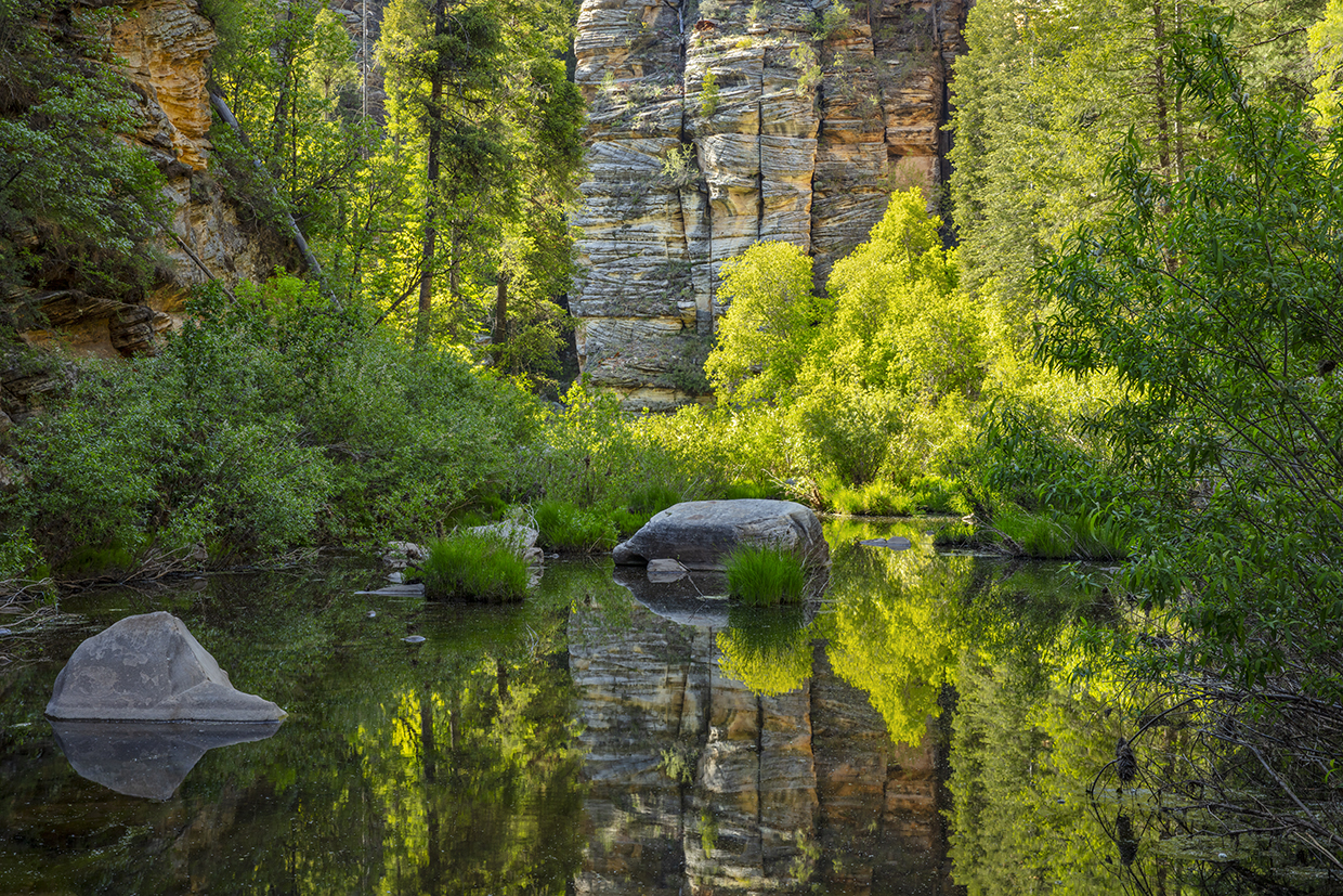
Like many trails on the Mogollon Rim, this one is rocky and loose in places. And it’s steep. After about 10 minutes of trekking, the canyon comes into full view. The rocks aren’t as red as the rocks in Oak Creek Canyon, but Willow Canyon is clearly a not-so-distant cousin. There are shades of Walnut Canyon as well. About a minute later, stop and look up. You’ll see an impressive rock wall over your right shoulder. The rocks above the rim are predominantly limestone, and they date back to when the area was covered by a shallow sea. In the canyon itself, the rocks, including the behemoth behind you, are sandstone, which also was deposited as sediment in an ancient ocean.
While you’re looking at the rocks and smelling the pines, listen for the sounds of birds. Like walking through the Scripps Aviary at the San Diego Zoo, you’ll be surrounded by winged creatures, including canyon wrens, northern flickers, mountain bluebirds, yellow warblers and Steller’s jays. The jays make the most noise. Along with the Gila woodpeckers. Some birds you’ll see. Some you won’t. But you’ll definitely get an earful.
Sight, smell, sound … this trail will tap into your senses. And it’s easy to get distracted, but you’ll need to watch your step. What this trail lacks in length, it makes up for in adventure. Pay attention, and after another 10 minutes, you’ll catch the first sounds of the creek, which is the payoff on this hike.
In all, it’s about 45 minutes from top to bottom — longer on the way out — and along the way, you’ll go from a transition zone of ponderosa pines, Douglas-firs and Gambel oaks to a riparian zone of red-osier dogwoods, ash, willows, wild rose, canyon grapes, box elders and poison ivy. Yes, poison ivy. Like learning to keep an eye out for pickpockets on the Charles Bridge in Prague, it’s important to learn how to spot Mother Nature’s little nuisance. “Leaves of three, let it be.” Keep your eyes peeled.
Meantime, the trail ends at the creek, which provides habitat for bluegills, chubs and suckers. Dragonflies like the moisture, too. And so will you. The sound of the creek, the sunlight dancing off the water, the grasses blowing in the breeze, the shrubs and trees surrounded by large rock walls ... it all adds up to a continuous stretch of country preserved in its natural state. Let’s keep it that way.
Trail Guide
Length: 1.4 miles round-trip
Difficulty: Moderate
Elevation: 6,710 to 6,089 feet
Trailhead GPS: N 34˚33.345', W 111˚24.295'
Directions: From Clints Well at the junction of State Route 87 and Forest Highway 3, go north on FH 3 for approximately 7 miles to Forest Road 81. Turn left onto FR 81 and continue approximately 4 miles to Forest Road 81E. Turn left onto FR 81E and continue to the end of the road.
Vehicle Requirements: A high-clearance vehicle, such as an SUV or truck, is required.
Dogs Allowed: Yes
Horses Allowed: Yes, but the trail is not suitable for horses.
USGS Map: Calloway Butte
Information: Mogollon Rim Ranger District, 928-477-2255 or fs.usda.gov/coconino