
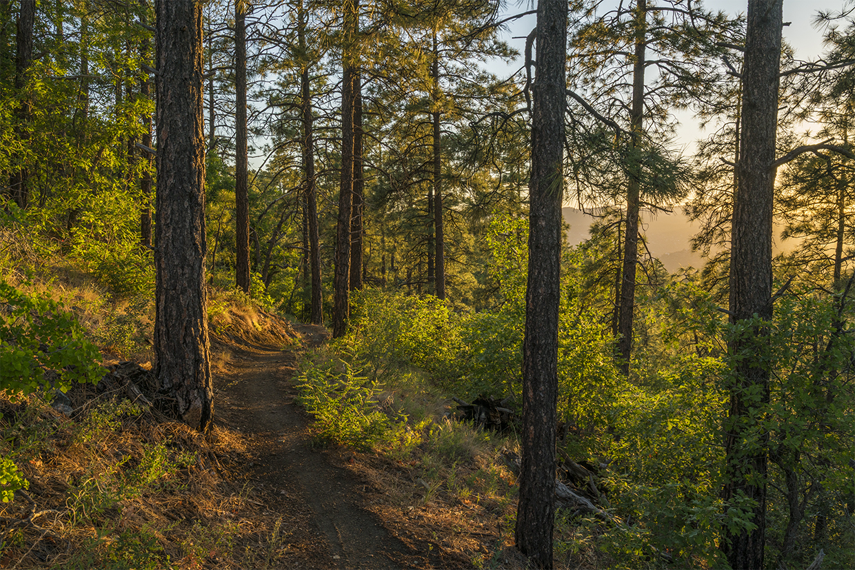
“I think I cannot preserve my health and spirits unless I spend four hours a day at least — and it is commonly more than that — sauntering through the woods and fields absolutely free from all worldly engagements.” Those words are from Walking, an essay by Henry David Thoreau. He would have liked the Ranch Trail. Walking, sauntering, ambling … that’s how you get from start to finish on this quiet trail in the Prescott National Forest. Unlike a mountain trail, which continually ascends to a summit, or a canyon trail, which does the opposite, this route moves up and down and up and down. Because of the rolling terrain, you’ll climb almost a thousand feet overall, even though the distance from the high point to the low point is only 400 feet.
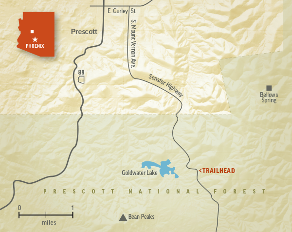
The trek begins at the Watershed Trailhead, just a few miles south of Prescott along the Senator Highway. From the north end of the parking lot, a rocky single track slips into the woods, where you’ll see a sign that marks the distance
to the Boy Scout Trail as 4.5 miles. But it’s farther than that. The actual distance is 5 miles.
From the sign, you’ll come to a series of short switchbacks that zigzag through a forest of small ponderosas. You’ll also get a glimpse of the Bean Peaks to the southwest, and perhaps some mountain bike tracks at your feet. Like most trails on the national forest, the Ranch Trail is open to hikers, horses and mountain bikers — e-bikes are not allowed.
Continuing up, the trail drops down into a small ravine and quickly climbs back out. A few minutes later, you’ll get your first look at Goldwater Lake to the west. The picturesque, 15-acre reservoir is a favorite for canoeing, kayaking and fishing. (Note to anglers: The lake is catch-and-release only, and it’s restricted to artificial flies or lures.)
About 20 minutes in, you’ll come to a good-sized alligator juniper. It’s the biggest on the trail, but nothing like the massive gator that grows beside a forest road in the Santa Maria Mountains, or the champion beneath Granite Mountain — some of the biggest gators in Arizona are older than Sir Francis Drake. The big tree on the Ranch Trail is relegated to the minor leagues, but it stands out nonetheless as the trail climbs to a point where it veers east into a thin forest. There are trees all around, but the canopy has holes, so it’s important to wear sunscreen on this hike. Any hike, really.
As the trail moves east, toward Government Canyon, you’ll get glimpses of Prescott to the northwest. Ideally, it’s nice to never see signs of civilization on a backcountry hike, but instead of seeing those quick looks as a negative, see them as a reminder that within a few minutes of Whiskey Row and the Hassayampa Inn, you can be out in the woods, crossing paths with mule deer and wild turkeys, and smelling the ponderosa pines. The first big “yellow belly” makes its appearance about 40 minutes in. Twenty minutes later, the trail begins a steep descent toward Forest Road 9854. You won’t see the road when you get there, but a short spur will take you to it. This junction marks the start of the homestretch.
Manzanitas, piñon pines, mountain mahoganies and low-growing shrub oaks line the way to an intersection with the Boy Scout Trail, not far from Bellows Spring. This is the turnaround point for this listing. However, if you have the time and stamina, you can hike for a few more miles to the the trail’s eastern trailhead, which is located just off of Walker Road. Another option is to coordinate a car shuttle — a system in which two sets of hikers start at opposite trailheads and trade car keys in the middle of the woods. Any of those options will work. Take your pick. What matters most is the woods. And the sauntering. And the walking. And the chance to be “absolutely free from all worldly engagements.”
Trail Guide
Length: 10 miles round-trip (to the Boy Scout Trail)
Difficulty: Strenuous
Elevation: 6,162 to 6,571 feet
Trailhead GPS: N 34˚29.696', W 112˚26.348'
Directions: From downtown Prescott, go south on Mount Vernon Avenue, which becomes the Senator Highway, for 4 miles to the Watershed Trailhead, on the left.
Vehicle Requirements: None
Dogs Allowed: Yes (on a leash)
Horses Allowed: Yes
USGS Map: Groom Creek
Information: Bradshaw Ranger District, 928-443-8000 or www.fs.usda.gov/r03/prescott