
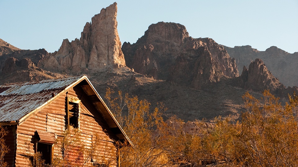
Black Mountains, Western Arizona
The fuel pump is an underrated part of automotive history — and something we take for granted today. Early cars relied on gravity to feed fuel to the carburetor, and that often made steep hills a challenge. One example: the Kingman-to-Topock section of Historic Route 66, where tow-truck operators made a fortune rescuing motorists in the 1920s and ’30s. The passage was arduous enough that Route 66 eventually was rerouted around it.
Today’s cars are better equipped to handle the curves and switchbacks. And that’s a good thing, because this drive — officially designated the Historic Route 66 Back Country Byway — offers stunning views and a visit to one of Arizona’s quirkiest small towns.
In Kingman, travel south on Route 66. Just past the Powerhouse building, which today serves as the Arizona Route 66 Museum, you’ll turn left and head toward the Black Mountains, a jagged range that once was a gold-mining hot spot. Along the way, you’ll pass 3,921-foot Thimble Mountain, part of the little-visited Mount Nutt Wilderness to the north. To the south is the Warm Springs Wilderness, which protects a pristine desert landscape.
Soon, you’ll begin climbing into the mountains, and you’ll find it hard to imagine Ma and Pa Joad tackling this route in their Hudson. Thankfully, this section was paved recently, so keep your eye on the road and you’ll be fine. You’ll find cold drinks, but no gas, at the rebuilt Cool Springs gas station, and ample pullouts along the road provide panoramas of the Sacramento Valley below and the Hualapai Mountains to the east. But the best view is at Sitgreaves Pass, the literal high point (3,586 feet) of the drive. If you can stop at only one pullout, that’s the one.
Not long after that, you’ll arrive in Oatman, a former gold-mining boomtown that now is all but a ghost town. Its most well-known modern residents are the dozens of burros that roam the town’s streets, seeking handouts from tourists. When Oatman’s mines went bust, the prospectors turned their pack animals loose, and these burros are the descendants of those beasts of burden.
After you’ve had enough of the burros and Oatman’s other attractions — the historic Oatman Hotel, for example — continue southwest on Route 66. Here, the road straightens out, and you’ll pass through ocotillos, teddy bear chollas and other desert flora as you approach Topock Marsh, part of Havasu National Wildlife Refuge.
What’s left of Arizona’s stretch of Route 66 ends at Interstate 40 near the Colorado River. From that intersection, you can see the Old Trails Bridge, whose 600-foot arch used to carry the route west into California. Today, it carries a natural-gas pipeline. From here, you could go birding in the wildlife refuge or take the express route back to Kingman on I-40. Or you could turn around and return the way you came. The views are just as good from west to east. But you’ll need a good fuel pump.
Note: Mileages are approximate.
Length: 57.5 miles one way
Directions: The entire drive is designated as Historic Route 66, but it follows several modern-day roads. From the intersection of Interstate 40 and Andy Devine Avenue in Kingman, go south on Andy Devine Avenue for 4 miles to where Route 66 splits off. Turn left to stay on Route 66, then continue 5 miles to Shinarump Drive. Turn right onto Shinarump Drive and continue 0.5 miles to Oatman Highway (the Historic Route 66 Back Country Byway). Turn left onto Oatman Highway and continue 25 miles, through Oatman, to a “Y” intersection. Bear left to stay on Route 66, then continue 23 miles to I-40 in Topock.
Vehicle requirements: None in good weather. The road crosses several washes, so don’t attempt the drive if rain is in the forecast.
Information: Kingman Field Office, 928-718-3700 or www.blm.gov/arizona; Oatman Chamber of Commerce, www.oatmangoldroad.org; Havasu National Wildlife Refuge, 760-326-3853 or www.fws.gov/refuge/havasu