
Sonoran Desert, Gila Bend
Emerson had it right: “There are many things of which a wise man might wish to be ignorant.” And these days, the constant stream of information to your smartphone can make ignorance seem particularly blissful. Luckily, despite the phone companies’ best efforts, there still are swaths of Arizona where you can’t get a signal. And many of them happen to be especially beautiful, too. Agua Caliente Road, which offers Sonoran Desert panoramas and a bit of history, is one of those.
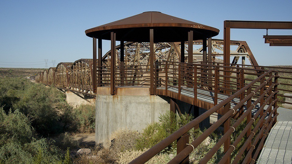
The route begins in Gila Bend, about 90 minutes from Phoenix. From Gila Bend, head north on Old U.S. Route 80, which once ran from San Diego to the Georgia coast. After a 22-mile jaunt past farmland and solar panels, you’ll reach the historic Gillespie Dam Bridge over the Gila River. Built in the 1920s, the steel truss bridge, one of the longest ever created in Arizona, was added to the National Register of Historic Places in 1981. It’s fared better than the dam just upstream, which partly collapsed in 1993 — turning the area around the bridge into a verdant riparian area that’s home to fish and waterfowl.
After you cross the bridge, it’s another 3.4 miles to Agua Caliente Road, on the left. A half-mile later, the road veers right and turns to dirt as it begins to wind through the low vegetation of the Sonoran Desert. To the south is the Woolsey Peak Wilderness, identified by its namesake rounded mountain (3,153 feet). To its northwest is the smaller Signal Mountain Wilderness. Both are home to desert bighorn sheep, mule deer and a variety of raptors.
After you curve around the Yellow Medicine Hills, you’ll start to notice more saguaros — there’s an interesting one with two long, vertical arms at
Mile 40.5. About 5 miles later, past Fourth of July Butte, is a nice view of the Gila Bend Mountains, which stretch across this area from northwest to southeast. Here, ocotillos and chollas are more prevalent than before, though saguaros still dominate the scenery — don’t miss the impressive one on the right side of the road around Mile 51.
Just past that cactus, the road begins to twist as it gains elevation. You’ll hit a high point at Mile 53.5. Pull over to enjoy the expansive view of the surrounding mountain ranges, then consider your next move. If you’d like a bit more history, you can continue on Agua Caliente Road to the ghost town of Sundad (accessible via a short hike or four-wheel-drive road), then turn left onto 555th Avenue and make your way south to Hyder, the old Agua Caliente resort and Interstate 8.
But if you’d like a different perspective on the beauty you just experienced, turn around and head back to Old U.S. 80, then return to Gila Bend or go north to Interstate 10 and the Phoenix area. Just be prepared for a lot of notifications on your phone once you get there. Ignorance is bliss, but it’s fleeting, too.
Note: Mileages are approximate.
Length: 53.5 miles one way
Directions: From Gila Bend, go north on Old U.S. Route 80 for 25.4 miles to Agua Caliente Road. Turn left (west) onto Agua Caliente Road and continue 28.1 miles to the drive’s stopping point.
Vehicle requirements: A high-clearance vehicle is recommended, but the route is passable in a standard sedan in good weather. Do not attempt the drive after heavy rain or if rain is in the forecast.
Warning: Back-road travel can be hazardous, so be aware of weather and road conditions. Carry plenty of water. Don’t travel alone, and let someone know where you are going and when you plan to return.
Information: Lower Sonoran Field Office, 623-580-5500 or www.blm.gov/az