
Prescott National Forest, Cottonwood
It isn’t easy to hike from one life zone to another. But that’s the allure of this strenuous trail. In the course of ascending almost 2,400 feet, you’ll go from the prickly pears, mesquites and junipers of the Upper Sonoran Life Zone to a lush forest of ponderosa pines, Gambel oaks and Arizona walnuts in what’s known as the Transition Life Zone. It’s the equivalent of taking a long ladder — about a half-mile long — pointing it to the sky and climbing to the top. There will be times along the way when you’ll curse the earth and beg for a respite, but the payoff is worth it.
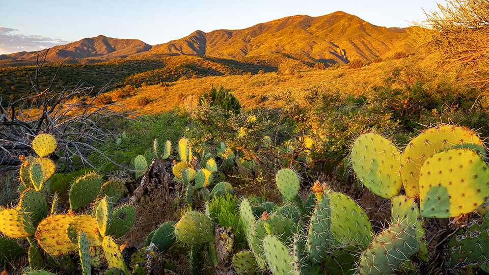
The trail begins at the end of a dirt road not far from downtown Cottonwood. Within a minute or two, the single track passes through a gate and into the expanse of the Prescott National Forest. The space between the junipers and prickly pears is filled by scrub grass and thorny vegetation — long pants or gaiters are strongly recommended.
Just beyond the gate, the trail dips into a small wash that gets splashed with spring runoff and summer rains. Usually, you won’t see water, but if you turn around, you will get some postcard views of Sedona, the Mogollon Rim and the San Francisco Peaks. And you might see the cobalt flash of a Steller’s jay or the siren red of a cardinal. Their bright colors stand out against the vast palette of forest green and sky blue.
After a series of gentle switchbacks, the trail begins a long zigzag climb up the north side of Black Canyon — on a GPS map, the route resembles an EKG strip. If you look to the southwest, you’ll see a silhouette of the tall ponderosas that line the distant Black Hills. Intuitively, you might think that’s where you’re headed. And in the next thought, you might think: There’s no way. I’m never going to make it that far. But, rest assured, those are trees for another day.
Continuing on, things remain the same until the trail passes through a gate that’s flanked by a barbed-wire fence. A few minutes later, it drops into a riparian wash lined with cottonwoods and sycamores. It’s good habitat for mule deer. After scrambling out, the slow ascent resumes. The grade is never excessively steep, but the cumulative effect of climbing the ladder tests your lung capacity and leg strength. Keep on truckin’.
About an hour later, the trail drops into another riparian wash, this one deeper and thicker than the last. It’s here that the route switches from the south-facing slope of the canyon to the north. And as the trail wraps around the crest of a butte, the manzanitas start showing up, along with some sizable alligator junipers. Naturally, things are more lush on the north-facing side. The soil’s different, too — there’s more dirt and less gravel. Also, the landscape now includes some oaks. It’s a nice change of pace, but the shift to the other side signals the start of one of the most grueling stretches of the day. It’s a slog that lasts about 45 minutes before reaching a saddle that sits amid a storybook grove of manzanitas.
From there, the trail drops steeply for about 200 feet into Gaddes Canyon, which is named for a pioneer family that lived in the area. This is where the Transition Life Zone begins. After almost three hours of crawling uphill on the exposed slopes of Black Canyon, you’ll be surprised to find yourself standing in a forest of big trees and thick grasses. There’s a small creek, too, which feeds several beautiful pools.
At this point, you’ll have hiked about 6.25 miles. It’s a good place to turn around, if your legs and lungs have had it. However, if you have something left, you can follow the creek for another mile and a half to the upper trailhead at Forest Road 413. The homestretch is a well-earned stroll beneath a canopy of trees that will shift from green to shades of yellow, red and gold when autumn rolls in. It’s the payoff on this trail, and a lesson in how different things can be when you hike from one life zone to another.
Length: 15.74 miles round-trip
Difficulty: Strenuous
Elevation: 3,872 to 6,254 feet
Trailhead GPS: N 34˚40.148', W 112˚02.174'
Directions: From the intersection of State Route 89A and State Route 260 in Cottonwood, go southeast on SR 260 for 2.6 miles to Forest Road 359 (Ogden Ranch Road). Turn right onto FR 359 and continue 4.2 miles to the trailhead.
Vehicle Requirements: None
Dogs Allowed: Yes (on a leash)
Horses Allowed: Yes
USGS Map: Cottonwood
Information: Verde Ranger District, 928-567-4121 or fs.usda.gov/prescott