
In Arizona, there are trails that climb to the tundra, there are trails that drop a mile into the earth, and there are trails that cut through the sets of Oscar-winning movies. Among the many classics filmed in Arizona is Oklahoma! — the exterior scenes for the musical were shot in the grasslands between Nogales and the Canelo Hills. The producer, Arthur Hornblow, learned about the area while leafing through the pages of Arizona Highways, where he saw a color photograph of the spacious San Rafael Valley. Whether or not the camera crew made it to Redrock Canyon and the other scenic points along this trail is unknown, but the entire area is a movie set. And it’s especially beautiful in August, when the summer rains whip up a palette of brilliant green.
The route begins at Canelo Pass, a well-marked trailhead for the Arizona Trail. Passage 3, the “Canelo Hills West” segment, runs for 16.6 miles from the pass to Patagonia. Like anywhere else on the AZT, you can hike as much or as little as you’d like. With a car shuttle (one car on either end), this segment can be done as a day hike. Otherwise, there are a few good turnaround points, including the water hole known as Down Under Tank.
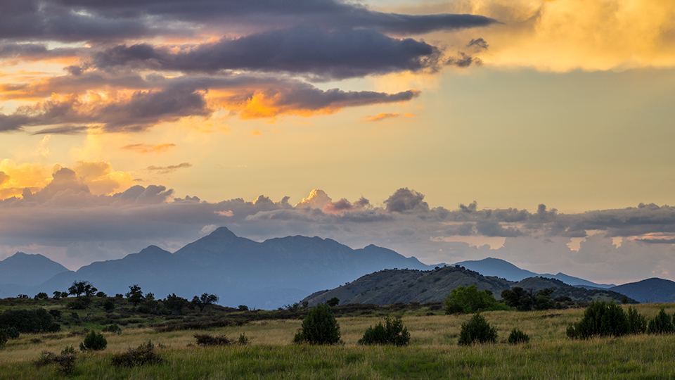
From the trailhead, veer right — the trail to the left leads to Passage 2 of the AZT. Manzanitas, alligator junipers and oaks line the rocky single-track. There’s a slight incline, but it’s not enough to take your breath away. That’s the job of the surrounding panorama. As you make the climb, turn around from time to time and take a look at the Huachuca Mountains, which dominate the horizon to the southeast. The views. It’s a thought you’ll have repeatedly on this hike.
About 15 minutes into the ascent, the trail dips into a wash that nourishes a beautiful grove of evergreen oaks and other hardy trees. Because this hike is a mile high, it’s pleasant even in the summer. The trees, however, offer some welcome shade if you’re feeling the effects of the altitude.
Beyond the grove, the trail begins a series of three long switchbacks. Two moderate zigs and one moderate zag. They lead to a saddle and the route’s first gate. With an elevation of 5,580 feet, this is the high point of the day hike. It’s also a lookout point. The place where you’ll get your first glimpse of the Santa Rita Mountains to the northwest and the Patagonia Mountains to the southwest. Everywhere you look, you’ll see mountains, rolling hills, shallow canyons and lush grasslands.
The rest of the route is downhill. At the outset, you’ll start seeing yuccas and Mexican piñon pines. In the distance, to the south, is the Meadow Valley Tank. And just beyond the first of several trail signs (this hike is extremely well marked), you’ll start seeing what appears to be a lovely green shrub with feathery leaves. But don’t be fooled. Commonly referred to as whitethorn, it’s a disgruntled resident of the hills, just waiting to hook your boots, your pants, your flesh ... it’s non-discriminating. Although volunteers do their best to keep it pruned back, it’s a good idea to wear gaiters.
Continuing down, you’ll get some nice views of the San Rafael Valley to the southwest. Then, at the 45-minute mark, the trail merges onto a two-track. Keep your eyes peeled for cow pies and thistles. About 10 minutes later, the route comes to an old jeep road. Cross the road and keep going forward. After passing through another impressive steel gate, things get a little steeper as the trail drops into a drainage — giant cairns point the way — and then into Redrock Canyon. A half-mile later, you’ll find yourself on a dirt berm that holds back the water in Down Under Tank, which is the turnaround point for this hike. However, if you have time, water and a little more energy, there’s more to see in the miles ahead. Distant mountains, rolling hills, verdant canyons, lush grasslands ... it’s like a scene from a classic Western. Or maybe an Oscar-winning musical.
Length: 7 miles round-trip (to Down Under Tank)
Difficulty: Moderate
Elevation: 5,580 to 4,987 feet
Trailhead GPS: N 31˚30.772', W 110˚33.495'
Directions: From Sonoita, go south on State Route 83 for 16.1 miles to Forest Road 799. Turn right onto FR 799 and continue 2.9 miles to the trailhead on the right.
Vehicle Requirements: A high-clearance vehicle, such as an SUV or truck, is recommended.
Dogs Allowed: Yes (on a leash)
Horses Allowed: Yes
USGS Map: O’Donnell Canyon
Information: Sierra Vista Ranger District, 520-378-0311 or fs.usda.gov/coronado