
Chiricahua Mountains, Coronado National Forest
In Spanish, centella means “flash.” Or “streak of lightning.” “Thunderbolt” is another way to say it. In either language, the vowels and consonants add up to a proper noun that’s well suited to this trail. Centella Point and the surrounding peaks are the lightning rods of the Chiricahua Wilderness. They get zapped on a regular basis. Some of those strikes take out a tree or two. The strike on June 28, 1994, took out 27,500 acres. That was the final count for the Rattlesnake Fire, which left a mosaic burn pattern that’s still evident along this route.
The hike begins at Rustler Park Campground. That’s where you’ll pick up the Crest Trail — the Crest Trail is the commuter line to the Centella Trail. At first glance, the hillside of burned-out trees above the campground will make you wonder what’s ahead. I sure hope it isn’t like this all the way to the point. It’s not, but the effects of the fire are striking in the initial stretch, which winds through the hallowed battlefield. Mixed in with the casualties are several stocky, young ponderosas. They’re about 4 feet tall, which isn’t high enough to offer any shade, but they do offer hope for an eventual resurrection of the forest.
In addition to the altered landscape, you’ll notice the wind. It whips across the mountain range like a Ferrari 488 at Le Mans. Hold on to your hat as you start the climb. It’s moderate for the first 20 minutes. Then it levels off as it cuts through an arsenal of thorny scrub brush. Gaiters are a good idea on this hike. On the other side of the scrub, the trail moves out of the burn area and into the forest. The scent of pine is heavy, and the floor is carpeted with pine cones. As you make your way, the trail hugs a steep, north-facing slope. Down below, you’ll catch a glimpse of Forest Road 42D.
Continuing on, the trail passes through an old gate that leads to some massive ponderosas. A few minutes later, the aspens start showing up. They, too, offer hope for an eventual resurrection. Beyond the aspens, which are about 20 feet tall, the trail arrives at Bootlegger Saddle and moves back into a burn zone. Like the space around the campground, this area was hit hard. Sadly, some of the trees lost to the Rattlesnake were more than 350 years old. The silver lining is that they’re being replaced by meadows and aspen groves and raspberry bushes and ferns and wildflowers. It’s part of the progression.
You’ll see a great example of that on the hillside to the left, which is covered with young aspens. It’s as if Bob Ross had some extra white space on his canvas and thought, This is a happy place for some pretty trees. Their bright green leaves will be quaking in the summer breeze as you make a slight descent to the boundary of the Chiricahua Wilderness, which protects 87,182 acres that once served as a home and refuge to the Chiricahua Apaches who were led by Cochise and Geronimo.
In addition to the aspens and ponderosas, the wilderness area is home to Mexican white pines, Apache pines, Chiricahua pines, Douglas firs, white firs, alligator junipers, oaks and the southernmost stand of Engelmann spruce in the United States. The trees are remnants of the last ice age. There’s wildlife, too, including javelinas, coatimundis, deer, mountain lions and black bears.
Just beyond the boundary, you’ll arrive at a junction of several trails, including the Centella Trail. The intersection looks like a railroad yard, with tracks going in all directions. It’s well marked, but if you don’t pay attention, you might end up at Flys Peak or Long Park.
Once on the Centella, you’ll pass through several groves of young aspens and spruce. In between are some of the innumerable trees that have toppled over in the wake of the fire — several crisscross the trail, like a losing hand of wilderness Jenga. You’ll have to limbo in a few places. Or scramble over. Nevertheless, this is a nice stretch of trail that meanders through the forest and eventually intersects the Bear Wallow Trail (no connection to the trail of the same name in the White Mountains).
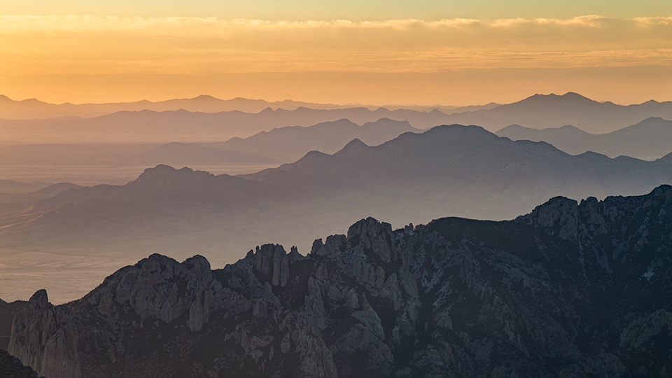
From there, the trail begins its final run to Centella Point. The point is the payoff. As you’ll see, the views to the south and east are spectacular. Soak it in, but be sure to look up, too. If there are monsoon clouds in the sky, you’ll want to hightail it back to Rustler Park. The point is called Centella for a reason. Beware of thunderbolts.
Length: 8.69 miles round-trip
Difficulty: Moderate
Elevation: 8,358 to 9,289 feet
Trailhead GPS: N 31˚54.405', W 109˚16.634'
Directions: From Willcox, go southeast on State Route 186 for 31.3 miles to State Route 181. Turn left onto SR 181 and continue 2.9 miles (toward Chiricahua National Monument) to Forest Road 42. Turn right onto FR 42 and continue 12 miles to Forest Road 42D. Turn right onto FR 42D and continue 2.7 miles to Rustler Park Campground. The trailhead is located at the campground.
Vehicle Requirements: A high-clearance vehicle, such as an SUV or truck, is recommended.
Dogs Allowed: Yes (on a leash)
Horses Allowed: Yes
USGS Map: Rustler Park
Information: Douglas Ranger District, 520-388-8436 or fs.usda.gov/coronado