
Tonto National Forest, Pine
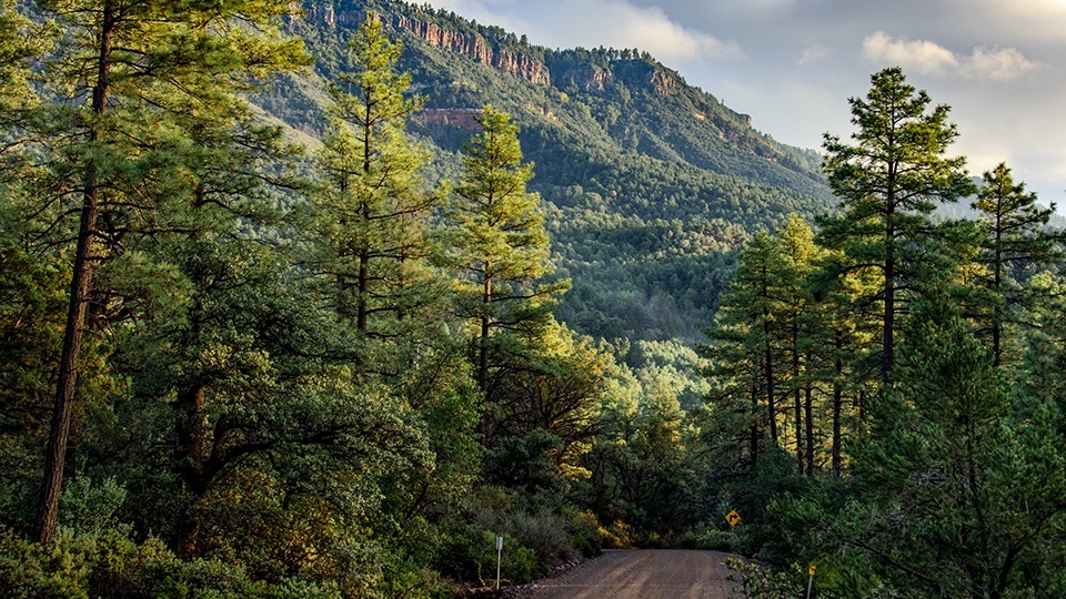
Don’t let the prosaic name fool you: Control Road north of Payson is a lovely historical route that runs below the Mogollon Rim — the dramatic ridge that defines the southern edge of the Colorado Plateau. Beginning near Pine, the meandering road rises and dips in and out of ponderosa pine forest for 23.4 miles, crossing seasonal streams and the East Verde River. It takes a little more than an hour to drive the well-graded gravel road, allowing time to enjoy some interesting stops and side trips that combine history, geology and a good dose of local color.
The Civilian Conservation Corps broke ground on Control Road in the summer of 1935, following the alignment of an older U.S. Forest Service road. Another Depression-era program, the Works Progress Administration, built on that work, constructing bridges over several low-water crossings frequently damaged by flooding. Only the original Webber Creek Bridge remains. The original span lies just to the right of the wider modern bridge in a grassy, sun-dappled stretch of forest about 5.5 miles from State Route 87.
A few miles later, the road intersects Forest Road 32. A 4-mile side trip leads to the community of Washington Park and a trailhead that accesses several historical and scenic trails. The arduous Colonel Devin Trail makes a 2-mile scramble to the site of an Apache battle at the top of The Rim. Based on a military trail used during the Apache Wars, the first 1.5 miles follow the East Verde River and Ellison Creek. A short but steep spur about a half-mile from the top leads to a 70-foot tunnel, the remains of a failed attempt to create a railroad passage in the 1880s.
The stretch of Control Road near the turnoff to Washington Park is also a good place to look for Arizona geodes, or “brain rocks” — which look like little brains on the outside but are round. You can also find fossil remnants of the ancient sea that once covered the area: brachiopods, like little fans, and ancient clams, among others.
About a mile farther, at Whispering Pines, Control Road veers left and crosses the East Verde, following the river for a short distance before descending into a stretch of oaks, junipers and manzanitas. It reaches Forest Road 65 about 9 miles later. On that road, a short side trip will take you to Diamond Point, with an expansive view near a fire tower built by the CCC. After a good rain, you might also see some of the impressive quartz crystals that gave the area its name lying exposed in the drainages.
Back on Control Road, gravel gives way to pavement around Mile 21, at Tonto Village. Here you’ll find the Double D bar and café, which makes an entertaining final stop, with dollar bills on the walls, peanut shells on the floor and a sign that reads: “Don’t drink and drive. You might hit a bump and spill your drink.” Naturally, there’s a pool table, a jukebox playing country music and a small gathering of friendly locals sporting well-worn cowboy hats and sprouting unkempt beards. The menu offers everything from breakfast to steaks. There’s also a full bar and enough beer of every variety to fuel a running conversation. Hang around long enough, the longtime bartender says, and you’ll hear just about everything.
Note: Mileages are approximate.
Length: 23.4 miles one way (from State Route 87)
Directions: From Pine, go southeast on State Route 87 (also State Route 260) for 2.4 miles to Control Road (Forest Road 64). Turn left onto Control Road and continue 23.4 miles to SR 260 near Kohls Ranch.
Vehicle requirements: None in good weather.
Warning: Back-road travel can be hazardous, so be aware of weather and road conditions. Carry plenty of water. Don’t travel alone, and let someone know where you are going and when you plan to return.
Information: Payson Ranger District, 928-474-7900
or www.fs.usda.gov/tonto