
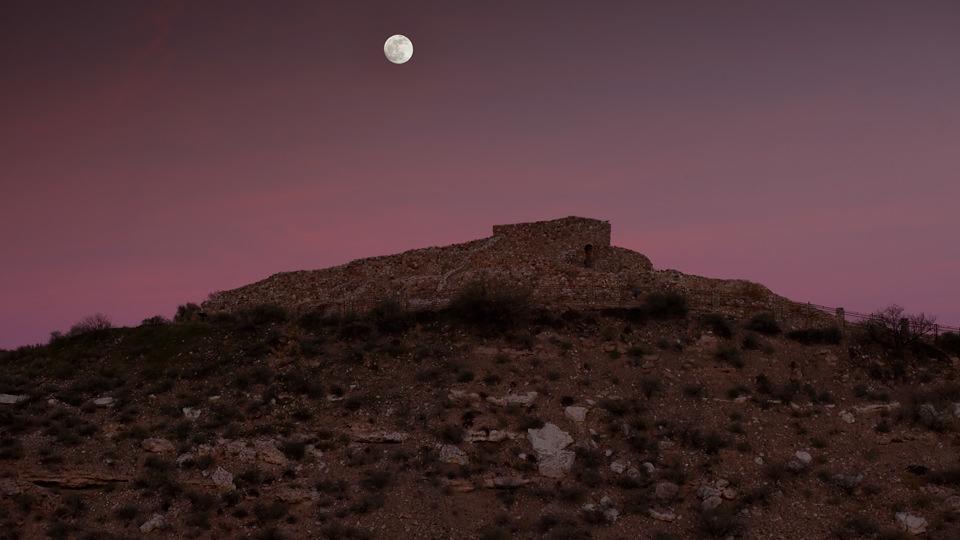
Tuzigoot National Monument
Everything old is new again. That phrase just about sums up the route from Cottonwood to Clarkdale, which follows three forest roads in the Verde Valley. The drive is all about seeing the very familiar from a very different vantage point.
This drive begins on Bill Gray Road (Forest Road 761), just off State Route 89A outside Cottonwood. After turning northwest onto FR 761, you’ll pass the All Souls Cemetery. Veer right, and you’ll spot a post with “761” etched on it. The rocky road is rough from the get-go and doesn’t improve much until you reach the end, some 19 miles later. Take it easy as you get a feel for nature’s potholes. The high-desert landscape is carpeted with spindly shrubs, cactuses and succulents. Meanwhile, the red rocks of Sedona will be on your right. There’s something magical about seeing Sedona from this vantage point. The wide-angle perspective feels undisturbed, even serene — maybe it’s the lack of car bumpers and brake lights.
For the next several miles, the road dips and rises repeatedly. The scenery shifts around Mile 4.5, when junipers appear in the landscape. As the road bends slightly west, the view of the red rocks gets interrupted around Mile 6 as power lines take center stage.
Just beyond the power lines, keep an eye out for a split in the road. The sign for Forest Road 258, which is your cue to turn left, is slightly obscured. After turning, you’ll ascend a very rocky and narrow road. Around Mile 7, the route comes to a “T” junction. Veer right and continue on FR 258. As the road and surrounding landscape open up, out of nowhere, chalky limestone dominates the scenery. No wonder Verde Valley winemakers love the area — this is the kind of soil that produces crisp Arizona juice. The road eventually plateaus around Mile 9.7, where you’ll be treated to a stunning view of Jerome, perched atop Cleopatra Hill. From there, the former mining colony has an Old World, fairy-tale quality about it that’s more difficult to see when you approach it from SR 89A.
As the road winds down and around the hill and into the backcountry, you’ll catch even more expansive views of the Verde Valley. By Mile 11, limestone gives way to clay, and in another 2 miles, you’ll reach another “T” junction. Turn left onto Forest Road 131. As you descend into the valley, keep an eye out for oncoming traffic — blind driveways lead from nearby homes. By Mile 15, the road dips, and lush vegetation canopies the pavement as you near the Verde River around Mile 16. The route follows the narrow river as it slices its way past hillsides that bear scars from the area’s early mining days. The road eventually turns to pavement at Mile 17, and after a brief climb, you’ll spot Tuzigoot National Monument on the left. The drive comes to an abrupt end when it intersects Tuzigoot Road. A left turn will take you to the ancient ruins. Turning right will take you into Clarkdale.
Note: Mileages are approximate.
Length: 19.2 miles one way
Directions: From State Route 89A in Cottonwood, go north on Bill Gray Road (Forest Road 761) for 6.2 miles to Forest Road 258. Turn left onto FR 258 and continue 7 miles to Forest Road 131. Turn left onto FR 131 and continue 6 miles to Tuzigoot Road. Turn left to visit Tuzigoot National Monument or right to continue to Clarkdale.
Vehicle requirements: A four-wheel-drive vehicle is recommended, though the route is passable by sedans in fair weather. Do not attempt the drive in inclement weather.
Information: Tuzigoot National Monument, 928-634-5564 or www.nps.gov/tuzi
Travelers in Arizona can visit www.az511.gov or dial 511 to get information on road closures, construction, delays, weather and more.