
The birthplace of basketball was in Massachusetts. Blue jeans were born in California. There isn’t a definitive point of origin for wilderness areas, but many conservationists point to the Gila River. The beginning can be traced back to 1924, when Aldo Leopold convinced the U.S. Forest Service that the headwaters of the Gila should be protected as the nation’s first primitive area. Forty years later, in 1964, Leopold’s early work, and the work of several others, led to the passage of the Wilderness Act. Today, the Gila River remains a vital lifeline for ecosystems in New Mexico and Arizona, and it’s the focal point of the first half of Passage 16 on the Arizona Trail.
The route, known as the “Gila River Canyons” segment, begins near the Kelvin-Riverside Bridge, just south of the small community of Kelvin, and runs for 25 miles toward Picketpost Mountain in the Tonto National Forest. Like anywhere else on the AZT, you can hike as much or as little as you’d like. With a car shuttle system (one vehicle on either end), a trek to the ghost town of Cochran (16 miles one way) makes an excellent day hike. Otherwise, there’s an old railroad bridge about 3 miles in that makes an obvious turnaround point.
From the parking area at the trailhead, backtrack about 50 yards on the dirt road to a steel gate marked with the AZT logo. The trail begins beyond the gate as a gravel two-track that drops down to the river. On the south bank is a set of railroad tracks that’s used by the Copper Basin Railway. To the right is a trail register. Sign in and start a steady climb through a landscape of saguaros, ocotillos, chollas and prickly pears. The saguaros in particular are impressive.
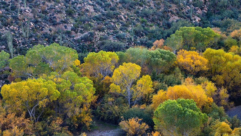
About 15 minutes in, after two long switchbacks around a side canyon, you’ll come to a low ridge with a distant look at the sycamores and cottonwoods that line the river like hordes of people at a Rose Bowl Parade. The trail, however, moves the other direction, away from the river, and keeps climbing. On the horizon to the north, you’ll see a slice of the massive Ray Mine, which dates to 1880. To the northwest is Granite Mountain. After a few minutes, the trail reverses direction and makes a slight descent to the south. After a few minutes more, it shifts west and climbs to an elevation of 2,160 feet on a rocky ridge that overlooks the river.
In addition to the beautiful panorama, this stretch includes a bit of history: The last mile of the Arizona Trail was completed on this ridge in the spring of 2012. It’s marked by a “golden spike” set in concrete and surrounded by native rocks. The concrete is inscribed with the initials “DS,” for the late Dale Shewalter, the father of the AZT.
From the overlook, the trail starts switching downhill toward the river. You’ll immediately catch a glimpse of the railroad bridge, which is nestled among the trees in the riparian area of the river. To a purist, the bridge might stand out as an eyesore, but if you can reconcile the fact that there are signs of mankind everywhere — including the trail upon which you’ll be hiking — there’s something nostalgic and timeless about the presence of an old bridge in the wide-open expanse of the Sonoran Desert. It also serves as a beacon. That’s where you’re headed.
But first there’s a 15-minute descent through the saguaros — look for a rare crested saguaro along the way. As the trail bottoms out, you’ll enter a thicket of mesquite trees, whose taproots can bore down as much as 200 feet in search of water. You’ll also see a spur trail that veers left and leads to the bridge, which is the turnaround point for this hike. If you have time, water and energy, there’s more to see in the miles ahead, including some of the most spectacular gorges in the state. But even if you’re limited to the trek from bridge to bridge, the experience will whet your appetite for further exploration of the Gila. It’s a beautiful river with an important history. Thank you, Mr. Leopold.
Length: 6.1 miles round-trip (to the railroad bridge)
Difficulty: Moderate
Elevation: 1,777 to 2,160 feet
Trailhead GPS: N 33˚06.395', W 110˚58.752'
Directions: From Superior, go southeast on State Route 177 for 15.5 miles to the Florence-Kelvin Highway. Turn right (south) onto the Florence-Kelvin Highway and continue 1.2 miles through the small community of Kelvin toward the Kelvin-Riverside Bridge. Just before the bridge, turn right onto Centurian Lane and continue 0.5 miles to the trailhead. Note: If parking is not available, continue 1.4 miles south on the Florence-Kelvin Highway to the Florence-Kelvin Trailhead.
Vehicle Requirements: None
Dogs Allowed: Yes (on a leash)
Horses Allowed: Yes
USGS Maps: Kearny, Grayback
Information: Tucson Field Office, 520-258-7200 or blm.gov/arizona