
Apache-Sitgreaves National Forests, White Mountains
In Arizona, there’s no better reminder of the importance of proper campfire management than the remnants of the Wallow Fire. The blaze started when an abandoned campfire spread to nearby trees, and it ultimately burned nearly 540,000 acres and became the largest recorded wildfire in the state’s history. Although you will see a few signs of Wallow’s devastation along this 21-mile, back-road route to Big Lake, you’ll also see swaths of grasslands, crystal-clear water and myriad reminders that the White Mountains are still spectacular.
The drive begins at the only traffic signal in Eagar, a small town that was first settled in 1871. As you head south, you’ll find yourself on Forest Road 285. The road is dirt, but it’s well maintained. If you’re traveling in a sedan, you’ll easily navigate FR 285 in good weather.
The road quickly climbs to an elevation of about 9,000 feet, so keep in mind that pockets of snow and ice may be present, even in summer. And it narrows to one lane in places, so watch for oncoming traffic and remember that if you come face to face with another motorist, the car traveling uphill has the right of way.
You’ll soon enter the Apache-Sitgreaves National Forests, where ponderosa pines, smaller evergreens and spindly, dance-in-the-wind aspens dominate the roadside as you wind your way into the forest. This is ungulate country, so take your time around the many blind corners — you never know when an elk might saunter across the road.
Aspens become more abundant as you gain elevation, and 10 miles in, the forest gives way to the first of several large meadows. The uninterrupted horizon to the southwest offers a good view of Mount Baldy. Baldy, one of the highest peaks in Arizona — its summit reaches 11,400 feet — is sacred to the Western Apache people, and its Apache name translates to “White Mountain,” which is easily understood by anyone who has seen it in the middle of winter.
A fairly constant breeze wafts over the meadows, so pull off the road, silence the sedan and enjoy the mountain air. If you’re lucky, you might see an animal — ungulate, turkey or otherwise — taking a drink at one of the many ponds near the roadside.
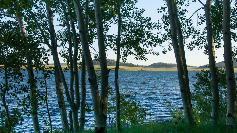
The last few miles of FR 285 plunge back into heavy forest, and although you’ll see a few areas where Wallow left its mark, a right turn onto Forest Road 249 takes you about 2 miles to Big Lake, one of the best lakes for fishing in Arizona and a great location for summer camping.
With a surface area of 450 acres, the lake is populated by rainbow, brook and cutthroat trout, which are stocked regularly by the Arizona Game and Fish Department. The lake’s five campgrounds are popular among families, but they don’t detract from the scenic beauty for which the lake is best known.
Even if you’re just passing through, take the short walk down to the water’s edge and listen to the waves. The greenery around Big Lake is a soothing reminder of Mother Nature’s ability to heal, and it’s a fitting conclusion to a spectacular drive.
Note: Mileages are approximate.
Length: 21 miles one way
Directions: From Show Low, go east on State Route 260 for 54 miles to Main Street in Eagar. Turn right onto Main Street and continue 1 mile to Forest Road 285 (Water Canyon Road). Turn left onto FR 285 and continue 18 miles to Forest Road 249. Turn right onto FR 249 and continue 2 miles to Big Lake Recreation Area, where FR 249 becomes State Route 273. To return to SR 260, either retrace your route or continue north on SR 273 to State Route 261, which intersects SR 260 near Eagar.
Vehicle Requirements: None
Information: Springerville Ranger District, 928-333-4301 or www.fs.usda.gov/asnf
Travelers in Arizona can visit www.az511.gov or dial 511 to get information on road closures, construction, delays, weather and more.