
Prescott to Seligman
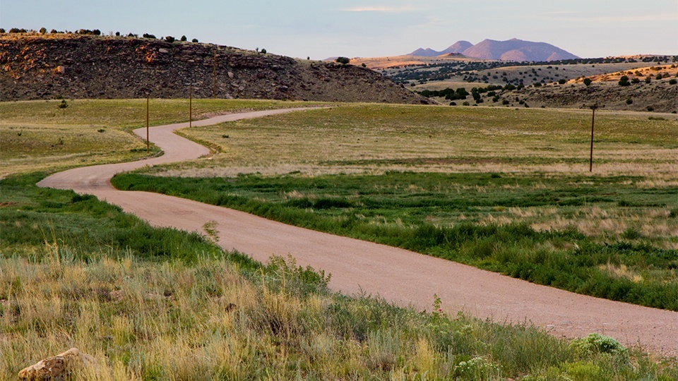
In many parts of the country, strip malls and subdivisions have crept into rural areas that contain treasured remnants of the past. Williamson Valley Road offers a journey in the opposite direction — through once-bustling frontier communities far from the nearest big-box store. On its winding 70-mile path from Prescott to Seligman, the road takes you back to Arizona’s rowdy Territorial days. The spectacular scenery and hiking trails along the way are gravy.
From Iron Springs Road in Prescott, turn onto paved Williamson Valley Road. To the northwest is the jagged profile of Granite Mountain. In 6 miles, the Williamson Valley Trailhead, on your left, offers a network of trails for a short jaunt around the mountain’s base or a daylong hike in the Granite Mountain Wilderness. Two miles beyond the trailhead is the site of a once-popular pit stop called American Ranch. In the 1860s and ’70s, when this road received regular traffic between Prescott and Fort Whipple, entrepreneur Jefferson Harrison Lee operated a stagecoach stop that included a hotel, store and duck pond. To protect himself and his wife, Agnes, during Apache raids, Lee allegedly dug an escape tunnel that was accessed through a hole in the floor. His house once burned to the ground during a raid, but he and Agnes emerged unscathed.
At Mile 20, you descend into lush Williamson Valley. On the left is the former site of the tiny hamlet of Simmons, where a stage stop and post office once operated. Longtime postmistress Betsy Zimmerman was well known for the vegetables she grew along the creek and brought to Prescott to sell.
Climbing into juniper-covered hills, the road turns to gravel for the rest of the way to Seligman. As it enters the Prescott National Forest, it becomes Forest Road 6 (also signed as County Road 5). Drink in the panoramic views to the east, with the glowing red rocks of Sedona on the horizon and Bill Williams Mountain to the north. At Mile 35.8, you come to a steel-truss bridge that seems out of place in such a remote setting. This novelty once was part of a seven-span bridge constructed across the Gila River in 1912, but it was washed out by floods in 1916. One of the surviving spans was relocated here in 1936 by the resourceful Arizona Highway Department.
Next, take a brief detour by turning left onto County Road 125 (Walnut Creek Road) and driving 1.8 miles to the site of Walnut Creek. In the late 19th century, this community was large enough to support a school and a post office. The Civilian Conservation Corps built a U.S. Forest Service ranger station here in the mid-1930s; today, it’s listed on the National Register of Historic Places. Just northeast of the ranger station is the town cemetery, with headstones that attest to a hard life on the frontier.
Once you return to Williamson Valley Road, the big views continue, and the appearance of 7,162-foot Picacho Butte to the north signals you’re approaching Seligman. The final stretch crosses the broad tableland of Big Chino Wash. But don’t get on the interstate just yet — ease back into the modern world with a ramble down Historic Route 66 in Seligman and a chocolate shake from Delgadillo’s Snow Cap Drive-In.
Note: Mileages are approximate.
Length: 70 miles one way (Williamson Valley Road)
Directions: From Courthouse Square in Prescott, go north on Montezuma Street, which becomes Whipple Street and then Iron Springs Road, for 3 miles to Williamson Valley Road. Turn right onto Williamson Valley Road and continue 70 miles to Seligman.
Vehicle requirements: A four-wheel-drive vehicle is recommended for the dirt portion of the road, especially in wet conditions.
Warning: Back-road travel can be hazardous, so be aware of weather and road conditions. Carry plenty of water. Don’t travel alone, and let someone know where you are going and when you plan to return.
Information: Chino Valley Ranger District, 928-777-2200 or www.fs.usda.gov/prescott