
Red Rock Ranger District, Coconino National Forest
You won’t see any bears on the Bear Mountain Trail. Unlike some of the other great “bear” trails in Arizona — Bear Canyon, Bear Jaw, Bear Wallow (R.I.P.) — this one doesn’t have any. The mountain gets its name from its peak, which resembles a bear. Sort of. Although it’s possible that a rogue male could wander into the area, the mountain and the trail that leads to it are more likely to attract birds, small mammals and ... people. Especially people who live in Sedona. Of all the great hikes in Red Rock Country, the Bear Mountain Trail is one of the locals’ favorites. And they’re drawn to it for a lot of reasons: The views from the top are as good as any in Sedona, it’s quieter than the town’s marquee trails, and it’s easy to get to. There just aren’t any bears.
The hike begins off a paved forest road about 15 minutes from downtown Sedona. From the trailhead, a wide dirt path heads north and immediately drops into and out of two rocky washes. If you hit the trail before sunrise, look to the southwest, where you’ll see the lights of Jerome softly illuminating the side of Mingus Mountain. After about 10 minutes, the path changes from red dirt to rock and starts to climb. Take a deep breath. This is the last real respite you’ll get — in the next 2 miles, you’re going to bag about 2,000 feet. The U.S. Forest Service says to plan on five hours round-trip for the hike. It shouldn’t take you that long, but it is a strenuous trek, so make sure your heart rate is where it needs to be, and take plenty of water.
Before you even break a sweat, you’ll arrive at the base of a small, craggy mountain and enter the Red Rock-Secret Mountain Wilderness. The trail narrows at this point and begins a steep, rocky scramble that’s reminiscent of the final stretch on Camelback Mountain. Sedonans will hate that comparison, but the mountains do have some things in common.
It takes about 15 minutes to scramble up. There’s a saddle of sorts at the end that offers another good look at Jerome. It also marks the first of several false summits — something else Bear Mountain has in common with Camelback. From there, the trail launches into another steep climb that switches for 500 feet to a second false summit on a broad plateau. To this point, the vegetation has been mostly prickly pears, piñons and manzanitas. But up on the plateau, you’ll start seeing alligator junipers, too.
As you make your way across the plateau, the climb continues, but it’s not as steep. Then, at the end of the plateau, the trail unexpectedly drops for about 100 yards, climbs again, drops again and climbs again. That’s the nature of this trail — it keeps you guessing.
About 75 minutes in, the hike begins another steep climb. This time, almost straight up without any switches. It leads to yet another false summit and spectacular views into Fay Canyon. This is where the final ascent begins. It’s the best part of the trail, too. As you make your way up, the route crosses what looks like Checkerboard Mesa in Zion National Park and presents a few more rock scrambles. Because long stretches of this hike cross bare rock, the trail can be hard to follow at times, but there are numerous cairns to keep you on track.
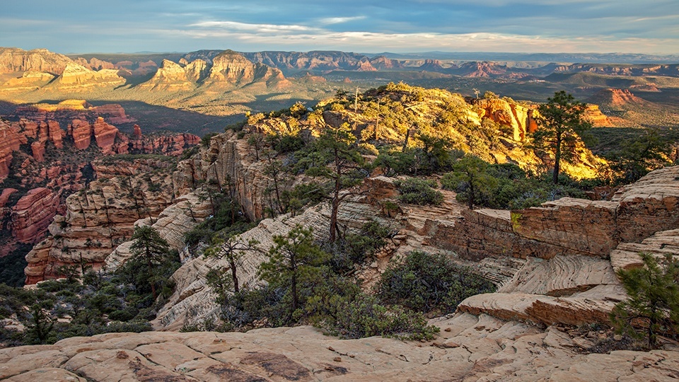
Eventually, after about two hours of almost nonstop trudging, you’ll arrive at the actual summit. There’s a lot to see on top, including a 3-foot pyramid of rocks that looks like something you’d find in the wake of Josey Wales, some great primitive campsites and several old gators. You’ll also see Red Rock Country, Jerome, Kendrick Peak and, way off to the north, the San Francisco Peaks. You can see forever from the top. You just can’t see any bears.
Length: 5 miles round-trip
Difficulty: Strenuous
Elevation: 4,587 to 6,447 feet
Trailhead GPS: N 34˚53.591’, W 111˚51.898’
Directions: From the roundabout intersection of State Route 179 and State Route 89A in Sedona, go southwest on SR 89A for 3.1 miles to Dry Creek Road. Turn right onto Dry Creek Road and continue 2.7 miles to Boynton Pass Road. Turn left onto Boynton Pass Road and continue 1.5 miles to Forest Road 152C. Turn left onto FR 152C and continue 1.2 miles to the trailhead parking area on the left.
Special Consideration: A $5 day pass is required.
Vehicle Requirements: None
Dogs Allowed: Yes (on a leash)
Horses Allowed: Yes, but the terrain is unsuitable for horses.
USGS Maps: Wilson Mountain, Loy Butte
Information: Red Rock Ranger District, 928-203-2900 or www.fs.usda.gov/coconino