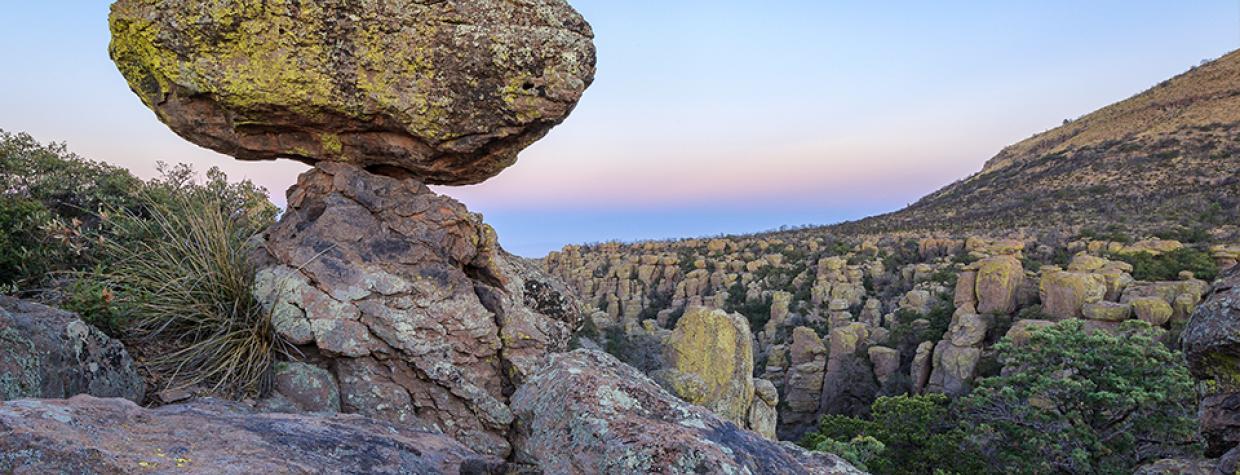
Chiricahua National Monument, Chiricahua Mountains
Every year, Chiricahua National Monument gets only about 60,000 visitors — roughly as many as you’ll find at the South Rim of the Grand Canyon over a holiday weekend. So, if you take your natural splendor with a side of social distancing, the wonders of the Chiricahua Mountains, in Southeastern Arizona, are tough to beat. And Bonita Canyon Drive, which winds past hoodoos and vistas on its way to the monument’s Massai Point, is an ideal starting point for an exploration of the Wonderland of Rocks.
From State Route 186, head east on State Route 181, which rolls through a lush grassland surrounded by mountains before it becomes Bonita Canyon Drive at the monument’s boundary. Just past that, on the right, you’ll see a small cemetery that’s a testament to the Chiricahuas’ human history. In the 1880s, Swedish immigrants Neil and Emma Erickson established Faraway Ranch, one of the area’s first permanent settlements; they and two of their children are buried in the cemetery. Faraway Ranch itself is a bit farther east, and an easy hiking loop offers views of the ranch house, which is listed on the National Register of Historic Places, and associated buildings.
Continuing east, the road winds past the monument’s visitors center, on the right; be sure to stop and pick up a map. Next, you’ll encounter a huge wall of hoodoos, known as the Organ Pipe Formation, on the left. These hoodoos are made of rhyolite, a type of volcanic rock laid down by an eruption 27 million years ago. After cracks and joints formed in the rhyolite, ice and water gradually enlarged those cracks until columns formed. Wind and other factors then smoothed the columns, eventually creating the oddly shaped forms we see today.
You’ll see more of those forms, many of them stained by yellow and green lichens, in the next couple of miles. Two of them, the Sea Captain and China Boy, are on the right side of the road around Mile 7.5. Look for a figure wearing an old-timey captain’s hat, followed by another anthropomorphic spire with an anachronistic name. In between glimpses of the hoodoos, oaks, junipers and other trees shade the roadway. They’re among the more than 1,000 plant species that grow within the monument’s boundaries.
The road next curves to the northeast and then to the south, offering a panorama of more of the Chiricahuas’ peaks and some ranges in New Mexico. Past a turnoff for the Echo Canyon and Sugarloaf trailheads — the latter trail is a short, steep route up Sugarloaf Mountain, one of the monument’s highest points — Bonita Canyon Drive ends at the parking area for Massai Point, which sits at an elevation of 6,870 feet.
Here, you’ll find a short nature trail, a small building of exhibits and an excellent view of Rhyolite Canyon, where countless hoodoos rise from the canyon walls. From Massai Point or the Echo Canyon Trailhead, you can access a loop hike through a grotto of hoodoos. And if you’re feeling ambitious, there are more trails farther south. Know your own limitations, though, and make sure you take plenty of water and food. You aren’t likely to run into too many people out there. That’s one of the great things about Chiricahua National Monument.
Note: Mileages are approximate.
Length: 10.4 miles one way (from State Route 186)
Directions: From Willcox, go southeast on State Route 186 (follow signs for Chiricahua National Monument) for 31.5 miles to State Route 181. Turn left onto SR 181, which turns into Bonita Canyon Drive, and continue 10.4 miles to the Massai Point parking area.
Vehicle requirements: None
Special considerations: There is no admission fee at Chiricahua National Monument. The monument’s visitors center is open from 8:30 a.m. to 4:30 p.m. year-round.
Information: Chiricahua National Monument, 520-824-3560 or nps.gov/chir

