
In the 1950s, more than 150 sites were in the running to be the United States’ first national astronomical observatory, but Kitt Peak, southwest of Tucson on the Tohono O’odham Nation, beat them all. At night, it’s not hard to see why: This peak in the isolated Quinlan Mountains offers a stellar view, literally and figuratively. But during the day, the view from the steep, twisting road to the observatory is just as heavenly to behold.
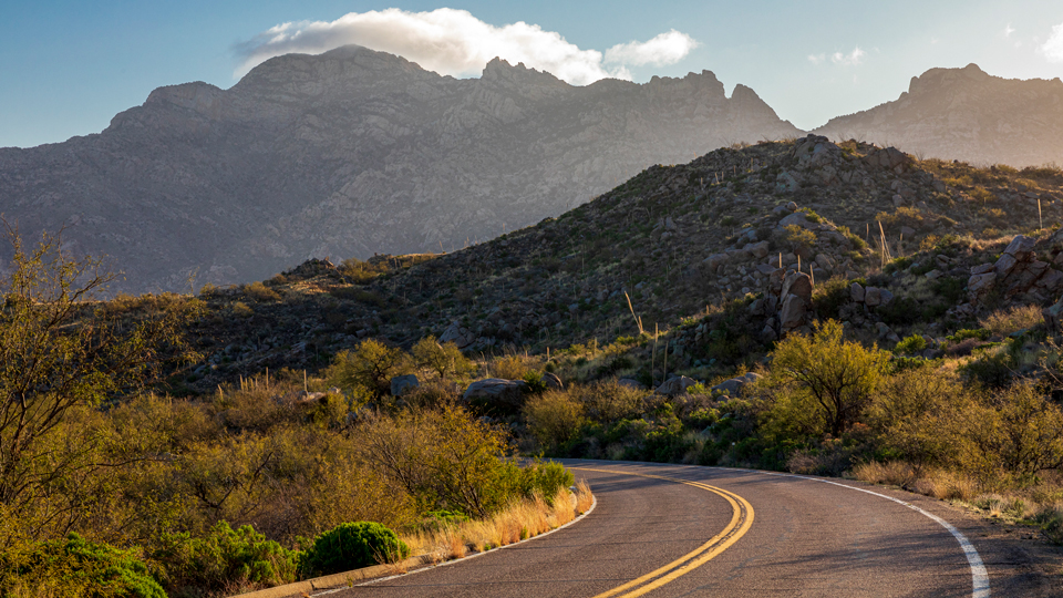
That road is State Route 386, which begins at a junction with State Route 86 northeast of the Tohono O’odham capital of Sells. The paved, well-maintained route’s initial stretch cuts through a broad plain of teddy bear chollas and prickly pear cactuses as it approaches the mountains to the south. Along the way, you’ll see one of Kitt Peak’s telescope domes to the southwest. On the east side of the road is the Coyote Mountains Wilderness, a 5,100-acre tract of sheer cliffs, open canyons, and habitat for bobcats and javelinas. Closer to the road, you might see mule deer or roadrunners.
After 2 miles, the road curves to the west and begins its climb to the summit. The cactuses give way to ocotillos and yuccas, and at Mile 3, you’ll reach a pullout that’ll show you how far you’ve already climbed. From here, you can see numerous mountain ranges, including the Silver Bells to the north — you’ll know them by the white band at their base, the result of mining activity. There are several pullouts in the next few miles, and because the road twists and turns so many times, each one offers a unique view. If you’re lucky, you’ll spot an acorn woodpecker — identified by its black body, white accents and bright red cap.
At Mile 8.4, a bend in the road opens the view to the west, and on a clear day, you’ll get a nearly limitless view of a vast desert plain studded with isolated mountain ranges. A quarter-mile later, as you curve around to the Quinlans’ south face, you’ll see the unmistakable rounded profile of Baboquivari Peak, the Tohono O’odhams’ most sacred place, to the south. It’s protected by its own wilderness area — at 2,040 acres, the smallest such area in Arizona.
The numerous domes of Kitt Peak National Observatory come into view a mile later, as the road turns to the north. The site is home to 25 optical telescopes and two radio telescopes, and signs ask you to put your cellphone in airplane mode to avoid interfering with these sensitive instruments. Past a picnic area at Mile 10.5, you’ll pass between steep rock faces on the left and another expansive vista on the right, then follow a few more curves before arriving at the Kitt Peak visitors center and parking area, at an elevation of 6,875 feet.
The observatory operates via a lease with the Tohono O’odham Nation, and three of its telescopes are usually open to the public via a self-guided tour — you can pick up a map at the visitors center. Guided tours, for a fee, are offered a few times a day, but it’s understandable if you’d rather take your time and take in the views from atop the mountain. The astronomers who work at Kitt Peak at night know the feeling.
Note: Mileages are approximate.
Length: 12 miles one way (from State Route 86)
Directions: From the intersection of Interstate 19 and State Route 86 (Ajo Way) in Tucson, go west on SR 86 for 37 miles to State Route 386. Turn left onto SR 386 (follow the signs for Kitt Peak) and continue 12 miles to the Kitt Peak National Observatory visitors center.
Vehicle requirements: None
Special considerations: The observatory grounds are open from 9 a.m. to 4 p.m. daily. Nighttime stargazing activities require advance registration; visit the observatory’s website for details. Daytime tours, both guided and self-guided, require substantial walking on hilly terrain at a high elevation.
Information: Kitt Peak National Observatory, 520-318-8726 or noao.edu/kpno