
Queen Valley, Superstition Mountains
Some scenic drives require a hefty time commitment and a lot of miles on the odometer. They’re worth it, of course, but sometimes you don’t have much of either to spare. That’s part of what makes the route to Elephant Butte so appealing. If you’ve got a high-clearance vehicle, you can make this trek to an appropriately named rock formation and be back on a major highway in 45 minutes or so — and encounter a thriving desert ecosystem along the way.
From U.S. Route 60 east of the Phoenix area, head north on Queen Valley Road. This paved, two-lane road winds for a few miles through a relatively lush stretch of the Sonoran Desert. Here, abundant chain fruit chollas mingle with prickly pear cactuses on either side of the road. If you make this drive in late spring, you’ll be able to enjoy the prickly pears’ colorful blooms.
To the north and northeast, the buttes of the Superstition Mountains jut skyward. The west face of this range is familiar to residents of the Valley of the Sun. So is the legend of the Lost Dutchman Gold Mine, a fabled mother lode that probably doesn’t exist. But that hasn’t stopped treasure hunters from scouring the “Supes” for more than a century in search of the pile of gold allegedly found by Jacob Waltz — who was German, not Dutch, by the way. Most of this mountain range is protected by the Superstition Wilderness, which covers more than 160,000 acres of desolate peaks and beguiling canyons.
Before long, you’ll reach the small community of Queen Valley, which is built around an 18-hole golf course that opened in the 1960s. After a few turns in town, you’ll find yourself on Elephant Butte Road, a dirt route that varies from wide and smooth to narrow and rocky. Initially, it skirts the northeast corner of the golf course; there are several unmarked side roads in this area, but just stay on the best-defined road and you’ll be fine.
Past the putting greens, the road curves to the northwest, then the northeast, as it enters another immaculate desert area. Here, teddy bear chollas and stately saguaros join the prickly pears and chain fruits; the resulting beauty is enough to make you forget about the high-tension power lines that pass overhead. In some places, you might notice a young saguaro growing in the shade of a large paloverde or mesquite; often, this “nurse tree” will die once the saguaro matures and robs it of water. (Tough break.)
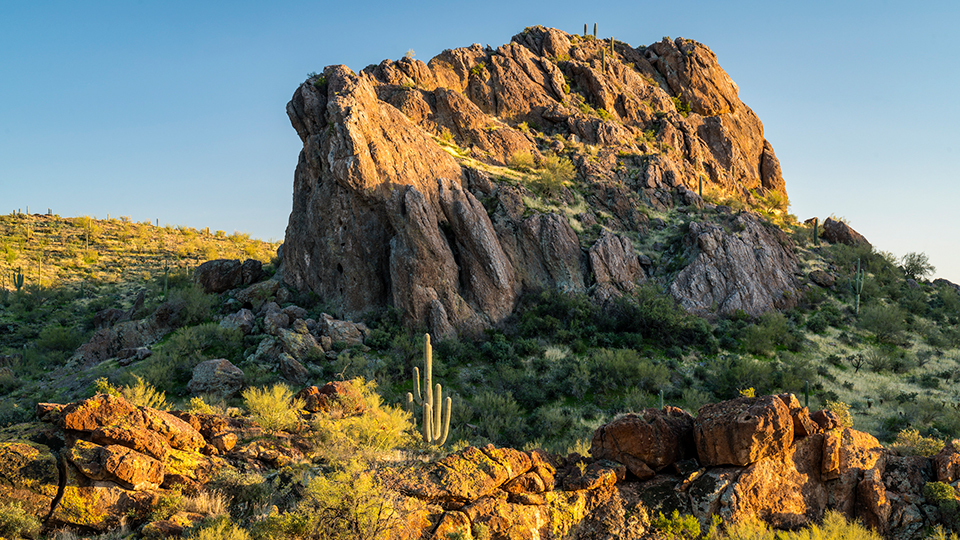
About 6.5 miles into the drive, you’ll crest a hill and see the landmark for which Elephant Butte Road is named. If you’re worried that you won’t know it when you see it, just know you’d have a hard time finding a more elephant-like butte than Elephant Butte, which tops out at 2,438 feet — not counting the saguaros growing on top of it. A half-mile later, just west of the butte, you’ll come to a “Y” intersection that marks the stopping point for this drive. To the right, Elephant Butte Road continues north for a few miles, but it’s in much worse shape than the stretch of road you just tackled. And you want to get back to civilization in time for lunch, right?
Note: Mileages are approximate.
Length: 7 miles one way (from U.S. Route 60)
Directions: From Superior, go west on U.S. Route 60 for 12.5 miles to Queen Valley Road. Turn right (north) onto Queen Valley Road and continue 3 miles to a “Y” intersection. Bear left to stay on Queen Valley Road, which turns into Queen Anne Drive, and continue 0.8 miles to Queen Valley Drive. Turn right onto Queen Valley Drive and continue 0.1 miles to Catherine Street (unmarked). Turn left onto Catherine Street, which turns into Elephant Butte Road, and continue 3.1 miles to Elephant Butte.
Vehicle requirements: A high-clearance vehicle is required, but four-wheel-drive is not necessary in good weather. Do not attempt the drive after recent rain or if rain is in the forecast.
Warning: Back-road travel can be hazardous, so be aware of weather and road conditions. Carry plenty of water. Don’t travel alone, and let someone know where you are going and when you plan to return.