
Cave Creek Ranger District, Tonto National Forest
Sheepherders never much liked the Verde River. In spring and fall, they had to swim their flocks across the water, leading them to summer pastures and winter ranges. It was dangerous business, and stray sheep often were lost to the river’s current.
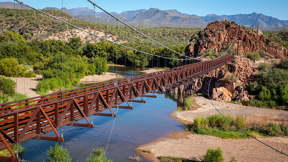
Finally, in 1944, the Flagstaff and Howard sheep companies completed construction of the Verde River Sheep Bridge, minimizing seasonal sheep loss and providing an easier entry to the west side of the Mazatzal wilderness.
Today, a replica bridge crosses a portion of the Verde River north of Carefree, and it’s the payoff to this scenic drive. But, like herding sheep across water, getting there takes a bit of work.
The route begins on the northeast outskirts of Carefree (just follow Cave Creek Road to the edge of town), a Phoenix suburb characterized by sprawling estates, cowboy-themed bars and plenty of antiques stores. As Cave Creek Road turns into Seven Springs Road after half a mile, the route, which to this point has been bordered by mesquites, creosotes and the occasional paloverde, dips into a riparian area. Here, the green leaves of sycamores seem to burst out of the desert landscape.
At 0.8 miles, you’ll pass the turnoff to Sears Kay Ruin, a Hohokam site that dates to 1500. It’s a focal point along the Great Western Trail, of which this road is part. Notice the power lines that punctuate this route, and you’ll scratch your head at the strange, sometimes-dysfunctional relationship between history, technology and nature.
Pavement ends at 2.6 miles, and the graded gravel road (now Forest Road 24) enters another riparian area before climbing again. Come spring, the hillsides that border the route will likely be awash with the wildflowers that carpet the Sonoran Desert — goldpoppies and lupines among them.
The drive continues past a few private properties and along boulders, fire-burned trees, prickly pear cactuses, saguaros and the occasional smattering of sacred datura for miles. Then, at Mile 9.5, it crosses Seven Springs and enters the Seven Springs Recreation Area. Here you’ll find a campground constructed by the Civilian Conservation Corps in 1934. Just up the road, you’ll find the Cave Creek Trailhead.
After the recreation area, FR 24 becomes narrower and a bit more rugged. It climbs again, and at Mile 14.3, you’ll leave Maricopa County and enter Yavapai County. Almost immediately, grasses emerge along the roadside, the century plants appear a bit greener, and the datura blooms in abundance here. Lockwood Mesa looms around Mile 16. You’ll notice an unexpected little grove of dead trees about a mile and a half past the mesa.
Finally, the road branches at Mile 27.9, and you’ll turn right onto Forest Road 269. Mesquite trees abound, and Tangle Peak rises on the left to an elevation of 3,542 feet. Wind-whipped junipers, groupings of saguaros and random cottonwoods are commonplace now, and they make the primitive, winding road more enjoyable. When you reach a cascade of boulders on the left side of the road at Mile 39.4, you’ll know you’re almost to the river. Then, after you pass the foundation of an old homestead at Mile 39.9, you’ll see them — the bridge and the river.
Here, the road ends. Get out of the car, walk across the bridge and think of the sheepherders who came before you. To return to Carefree, retrace your route. Alternately, it’s possible to travel FR 269 back the way you came, then continue west for another 27 miles through Agua Fria National Monument to Interstate 17.
If you choose the latter, you’re in for a stunning trek, but it’s a long one. Once you hit pavement again, you’ll be ready to head home. And count some sheep.
Note: Mileages are approximate.
Length: 39.9 miles one way
Directions: From Carefree, go north on Cave Creek Road, which becomes Seven Springs Road (Forest Road 24), for 27.9 miles to Forest Road 269. Turn right onto FR 269 and continue 12 miles until the road ends at the Verde River Sheep Bridge.
Vehicle Requirements: A high-clearance vehicle is required, and a four-wheel-drive vehicle is recommended for Forest Road 269. This route should not be attempted in inclement weather.
Warning: Back-road travel can be hazardous, so be aware of weather and road conditions. Carry plenty of water. Don’t travel alone, and let someone know where you are going and when you plan to return.
Information: Cave Creek Ranger District, 480-595-3300 or www.fs.usda.gov/tonto